
Harrison County, West Virginia facts for kids
Quick facts for kids
Harrison County
|
||
|---|---|---|

Harrison County Courthouse
|
||
|
||

Location within the U.S. state of West Virginia
|
||
 West Virginia's location within the U.S. |
||
| Country | ||
| State | ||
| Founded | May 3, 1784 | |
| Named for | Benjamin Harrison V | |
| Seat | Clarksburg | |
| Largest city | Clarksburg | |
| Area | ||
| • Total | 417 sq mi (1,080 km2) | |
| • Land | 416 sq mi (1,080 km2) | |
| • Water | 0.5 sq mi (1 km2) 0.1%% | |
| Population
(2010)
|
||
| • Total | 69,099 | |
| • Estimate
(2019)
|
67,256 | |
| • Density | 165.71/sq mi (63.98/km2) | |
| Time zone | UTC−5 (Eastern) | |
| • Summer (DST) | UTC−4 (EDT) | |
| Congressional district | 1st | |

Harrison County is a county in the U.S. state of West Virginia. As of the 2010 census, the population was 69,099. The county seat is Clarksburg.
Harrison County is part of the Clarksburg, WV Micropolitan Statistical Area.
Contents
History
White trappers visited the area that is now Harrison County as early as the 1760s when it was still part of the vast Augusta County, Virginia. The settler Daniel Davisson claimed the land upon which present-day Clarksburg, Harrison County was formed in 1773, when the area was still part of the vast Monongalia County, Virginia.
Harrison County was created in 1784, formed from Monongalia County and named for Benjamin Harrison V, who had recently retired as the Governor of Virginia. (He was the father of William Henry Harrison, 9th President of the United States and great-grandfather of Benjamin Harrison, 23rd president.) From the vast territory that was called “Harrison County” in 1784 were carved, over the next 72 years, all of eight present day West Virginia counties and parts of ten others.
The first meeting of the Harrison County court was held on July 20, 1784 at home of George Jackson. One of the first orders of business was to select a permanent county seat. It was decided to move the county seat to Clarksburg. The town, named in honor of the explorer General George Rogers Clark (1752–1818), was chartered by the Virginia General Assembly in October 1785, and it was incorporated in 1795.
Clarksburg's first newspaper, The By-Stander, began publication in 1810. Clarksburg began to grow following the construction of the Northwestern Turnpike connecting Winchester and Parkersburg, which reached it in 1836. Clarksburg's economic development was also helped by the arrival of the Baltimore and Ohio Railroad in 1856. The railroad was instrumental in the development of the local coal mining industry during the late 1800s and early 1900s.
Geography

According to the U.S. Census Bureau, the county has a total area of 417 square miles (1,080 km2), of which 416 square miles (1,080 km2) is land and 0.5 square miles (1.3 km2) (0.1%) is water. The county is drained by the West Fork River and its tributaries, including Tenmile Creek, Simpson Creek, Elk Creek, and Hackers Creek.
Major highways
 Interstate 79
 U.S. Route 19
 U.S. Route 50
 West Virginia Route 20
 West Virginia Route 23
 West Virginia Route 57
 West Virginia Route 58
 West Virginia Route 76
 West Virginia Route 98
 West Virginia Route 131
 West Virginia Route 270
Adjacent counties
- Marion County (north)
- Taylor County (east)
- Barbour County (east)
- Upshur County (southeast)
- Lewis County (south)
- Doddridge County (west)
- Wetzel County (northwest)
Demographics
| Historical population | |||
|---|---|---|---|
| Census | Pop. | %± | |
| 1790 | 2,080 | — | |
| 1800 | 4,848 | 133.1% | |
| 1810 | 9,958 | 105.4% | |
| 1820 | 10,932 | 9.8% | |
| 1830 | 14,722 | 34.7% | |
| 1840 | 17,669 | 20.0% | |
| 1850 | 11,728 | −33.6% | |
| 1860 | 13,790 | 17.6% | |
| 1870 | 16,714 | 21.2% | |
| 1880 | 20,181 | 20.7% | |
| 1890 | 21,919 | 8.6% | |
| 1900 | 27,690 | 26.3% | |
| 1910 | 48,381 | 74.7% | |
| 1920 | 74,793 | 54.6% | |
| 1930 | 78,567 | 5.0% | |
| 1940 | 82,911 | 5.5% | |
| 1950 | 85,296 | 2.9% | |
| 1960 | 77,856 | −8.7% | |
| 1970 | 73,028 | −6.2% | |
| 1980 | 77,710 | 6.4% | |
| 1990 | 69,371 | −10.7% | |
| 2000 | 68,652 | −1.0% | |
| 2010 | 69,099 | 0.7% | |
| 2019 (est.) | 67,256 | −2.7% | |
| US Decennial Census 1790–1960 1900–1990 1990–2000 2010–2019 |
|||
2010 census
As of the 2010 United States Census, there were 69,099 people, 28,533 households, and 18,992 families in the county. The population density was 166/sqmi (64.1/km2). There were 31,431 housing units at an average density of 75.6/sqmi (29.2/km2). The racial makeup of the county was 96.0% white, 1.6% black or African American, 0.5% Asian, 0.2% American Indian, 0.2% from other races, and 1.5% from two or more races. Those of Hispanic or Latino origin made up 1.3% of the population. In terms of ancestry, 19.8% were German, 19.0% were American, 18.3% were Irish, 13.2% were English, and 10.4% were Italian.
Of the 28,533 households, 30.0% had children under the age of 18 living with them, 49.7% were married couples living together, 11.9% had a female householder with no husband present, 33.4% were non-families, and 28.3% of all households were made up of individuals. The average household size was 2.39 and the average family size was 2.92. The median age was 41.8 years.
The median income for a household in the county was $39,191 and the median income for a family was $46,882. Males had a median income of $42,615 versus $28,867 for females. The per capita income for the county was $21,010. About 15.0% of families and 18.9% of the population were below the poverty line, including 29.0% of those under age 18 and 9.1% of those age 65 or over.
Communities
Cities
- Bridgeport
- Clarksburg (county seat)
- Salem
- Shinnston
- Stonewood
Towns
Census-designated places
Unincorporated communities
Charles Pointe Master-Planned Community
Harrison County is the site of a master-planned community, Charles Pointe, which is currently under construction in the city of Bridgeport, WV and comprises 1,700 acres (6.9 km2) that will combine commercial, residential, and recreational areas into one master-planned community. Adjacent to Charles Pointe, the new United Hospital Center, a $278 million state-of-the-art medical facility, is also currently being constructed. Directly across from the United Hospital Center site, White Oaks, a planned business community is also under way, and will support the new hospital and the FBI CJIS complex, which is also located nearby to the White Oaks site. This area of West Virginia's Interstate 79 is considered part of a "High Tech Corridor."
Historical landmarks
- Simpson Creek Covered Bridge
- Fletcher Covered Bridge
- Oak Mounds
- Kelly Miller High School
- The Waldomore
Notable people
- John W. Davis, Democratic Party candidate for President in 1924
- Guy Goff, Republican Party United States Senator
Images for kids
-

Left, the West Virginia Black Heritage Festival in Clarksburg, WV. Center, the Scottish Festival & Celtic Gathering in Bridgeport, WV. Right, the West Virginia Italian Heritage Festival in Clarksburg.
-
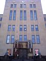
Harrison County Courthouse
-
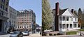
Views of Main Street in Clarksburg (left) and the Benedum Civic Center in Bridgeport (right). Clarksburg and Bridgeport are the largest cities in Harrison County.


See also
 In Spanish: Condado de Harrison (Virginia Occidental) para niños
