
Harrisville, New Hampshire facts for kids
Quick facts for kids
Harrisville, New Hampshire
|
|
|---|---|
|
Town
|
|

The historic mill village of Harrisville
|
|

Location in Cheshire County, New Hampshire
|
|
| Country | United States |
| State | New Hampshire |
| County | Cheshire |
| Incorporated | 1870 |
| Villages | Harrisville Chesham |
| Area | |
| • Total | 20.2 sq mi (52.4 km2) |
| • Land | 18.6 sq mi (48.3 km2) |
| • Water | 1.6 sq mi (4.1 km2) 7.79% |
| Elevation | 1,335 ft (407 m) |
| Population
(2020)
|
|
| • Total | 984 |
| • Density | 53/sq mi (20.4/km2) |
| Time zone | UTC-5 (Eastern) |
| • Summer (DST) | UTC-4 (Eastern) |
| ZIP code |
03450
|
| Area code(s) | 603 |
| FIPS code | 33-34420 |
| GNIS feature ID | 0873620 |
Harrisville is a town in Cheshire County, New Hampshire, United States. Besides the town center, it also includes the villages of Chesham and Eastview. The population of the town was 984 at the 2020 census.
Harrisville is a unique, preserved 19th-century mill town located in the Monadnock region of southern New Hampshire. There are nine bodies of water in the town, many back roads and trails to explore, and two original train depots at Harrisville and Chesham.
Contents
History
First known as Twitchell's Mills, a combination sawmill and gristmill was built here in 1774. Harrisville township was formed in 1870 from lands ceded by Marlborough, Dublin, Hancock, Nelson, and Roxbury. The Manchester & Keene Railroad opened in 1878, helping it prosper as a textile mill town. It was named for Milan Harris, whose stone and brick Cheshire Mills operated until 1970, but look virtually unchanged since the mid-19th century.
Today, the Cheshire Mills are protected as part of the Harrisville Historic District, a National Historic Landmark which includes the center of town. With its red brick buildings and mills reflected in Harrisville Pond and canal, the village is frequently photographed as an iconic example of picturesque old New England. The Harrisville Rural District includes the southern part of the town near the Dublin border.
-
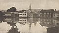
Town view c. 1905
-
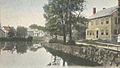
Looking up canal in 1914
-
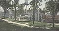
Cheshire Mills c. 1915


Geography
According to the United States Census Bureau, the town has a total area of 20.2 square miles (52 km2), of which 18.6 square miles (48 km2) is land and 1.6 square miles (4.1 km2) is water, comprising 7.80% of the town. The highest point in Harrisville is the summit of Cobb Hill, at 1,909 feet (582 m) above sea level. Roughly the western half of Harrisville, drained by Minnewawa Brook, lies within the Ashuelot River watershed, part of the Connecticut River basin, while the eastern half, drained by Nubanusit Brook, is in the Merrimack River watershed. Significant lakes include Silver Lake, Seaver Reservoir, and Chesham Pond on the western side, and Harrisville Pond and Skatutakee Lake draining to the east.
Demographics
| Historical population | |||
|---|---|---|---|
| Census | Pop. | %± | |
| 1880 | 870 | — | |
| 1890 | 748 | −14.0% | |
| 1900 | 791 | 5.7% | |
| 1910 | 623 | −21.2% | |
| 1920 | 559 | −10.3% | |
| 1930 | 512 | −8.4% | |
| 1940 | 509 | −0.6% | |
| 1950 | 519 | 2.0% | |
| 1960 | 459 | −11.6% | |
| 1970 | 584 | 27.2% | |
| 1980 | 860 | 47.3% | |
| 1990 | 981 | 14.1% | |
| 2000 | 1,075 | 9.6% | |
| 2010 | 961 | −10.6% | |
| 2020 | 984 | 2.4% | |
| U.S. Decennial Census | |||
As of the census of 2000, there were 1,075 people, 449 households, and 306 families residing in the town. The population density was 57.4 people per square mile (22.1/km2). There were 698 housing units at an average density of 37.2 per square mile (14.4/km2). The racial makeup of the town was 97.77% White, 0.09% African American, 0.56% Native American, 0.28% Asian, and 1.30% from two or more races. Hispanic or Latino of any race were 0.56% of the population.
There were 449 households, out of which 31.2% had children under the age of 18 living with them, 55.2% were married couples living together, 8.9% had a female householder with no husband present, and 31.8% were non-families. 26.5% of all households were made up of individuals, and 7.8% had someone living alone who was 65 years of age or older. The average household size was 2.39 and the average family size was 2.87.
In the town, the population was spread out, with 24.8% under the age of 18, 4.6% from 18 to 24, 25.7% from 25 to 44, 30.0% from 45 to 64, and 15.0% who were 65 years of age or older. The median age was 43 years. For every 100 females, there were 92.3 males. For every 100 females age 18 and over, there were 87.0 males.
The median income for a household in the town was $48,625, and the median income for a family was $55,083. Males had a median income of $34,625 versus $27,171 for females. The per capita income for the town was $25,397. About 4.3% of families and 5.7% of the population were below the poverty line, including 8.0% of those under age 18 and 3.8% of those age 65 or over.
Education
The elementary school is Wells Memorial School in Chesham.
See also
 In Spanish: Harrisville (Nuevo Hampshire) para niños
