
Harrow, London facts for kids
Quick facts for kids Harrow, London |
|
|---|---|
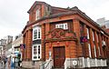
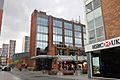
    Clockwise from top: St John the Baptist, Greenhill church; Skipping Katie statue; University of Westminster; Hygeia Building and King's House
|
|

Harrow, London
|
|
| Population | 149,246 (2011 Census) |
| Demonym | Harrovian |
| OS grid reference | TQ145885 |
| • Charing Cross | 11 mi (18 km) ESE |
| Ceremonial county | Greater London |
| Region | |
| Country | England |
| Sovereign state | United Kingdom |
| Post town | Harrow, London |
| Postcode district | HA1, HA2, HA3 |
| Dialling code | 020 |
| Police | Metropolitan |
| Fire | London |
| Ambulance | London |
| EU Parliament | London |
| UK Parliament |
|
Harrow is a large town in Greater London, England, and serves as the principal settlement of the London Borough of Harrow. Lying about 9.5 miles (15.3 km) north-west of Charing Cross and 5.4 miles (8.7 km) south of Watford, the entire town including its localities had a population of 149,246 as of the 2011 census, whereas the wider borough (which also contains Pinner and Stanmore) had a population of 250,149.
The historic centre of Harrow was atop the 408 feet (124 m) Harrow Hill. The modern town of Harrow grew out at the foot of the settlement, in what was historically called Greenhill. With the arrival of the Metropolitan Railway in the 19th century, the centre of Harrow moved to Greenhill and it grew as the unofficial "capital" of the Metroland suburbia in the early 20th century; Harrow-on-the-Hill station is on one of the railway corridors between London and the Chilterns. Meanwhile, Harrow & Wealdstone station is on the West Coast Main Line and is the eighth oldest railway station, having opened in 1837 one and a half mile north of the hill. Workers were drawn to the area by the opening of several factories in Wealdstone; Harrow was the base of the large Kodak factory, used for the manufacture of photographic materials and R&D, which was in operation for more than a century.
Historically in the hundred of Gore, county of Middlesex, the merged Harrow was a municipal borough before it became a part of Greater London in 1965. Today, the historic area is distinguished as Harrow on the Hill and is a conservation area with listed buildings of Georgian architecture and home to Harrow School, one of the seven major boys' boarding schools in England as defined by the Public Schools Act 1868. The modern-day town meanwhile is an established commercial centre of outer north-west London and houses a campus of the University of Westminster.
Contents
Etymology
Harrow's name comes from Old English hearg = "(heathen) temple", which was probably on the hill of Harrow, where St. Mary's Church stands today. The name has been studied in detail by Keith Briggs.
Arts and culture
The first and only contemporary artist-led gallery in Harrow was set up in 2010 by the Usurp Art Collective. The space is called the Usurp Art Gallery & Studios and is based in West Harrow, a bohemian part of Harrow. Usurp Art provides professional support to artists and runs the only public artists studios in the borough. It is a flagship project for Arts Council England.
Development and history
Harrow proper is identified as one of the 11 Metropolitan centres in the London Plan.
Geography
 |
North Harrow | Wealdstone | Belmont | |
| West Harrow | Kenton | |||
| South Harrow | Harrow on the Hill | Northwick Park |

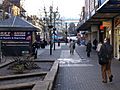
Harrow forms a commercial hub in northwest London, including a well-connected town centre containing:
- two shopping centres
- Parades of shops throughout Station Road and the ascending, traditional College Road
- Over 300 m of a fully pedestranised shopping/cafe streets roads (north of St Ann's)
Harrow historically included Harrow on the Hill, which sits on top of an outlying knoll and is contiguous with the centre of Harrow. Much of Kenton and before 1716 all of Pinner were parts of Harrow, geographical facts which root the importance of Harrow as a meeting place and a place of business. Harrow Weald, is the district north of Wealdstone, both of which were historically also part of Harrow. Harrow may also include the wards of Roxeth, Marlborough, Headstone North and Harrow on the Hill as well as the Greenhill, West Harrow and Headstone South wards listed above. The combined population of these wards is 80,213 (2011).
Demography

The town includes its localities within the Harrow post town: Harrow on the Hill, Harrow Weald, Headstone, North Harrow, Kenton, Rayners Lane, South Harrow, Wealdstone and West Harrow. The Borough's population was 250,149 in 2011.
Harrow Borough's proportion of Jewish, Muslim and Hindu residents is above average. The ethnic minority population includes a large and established Gujarati Indian community, who originally settled in large numbers in the borough after their expulsion from Uganda in 1972.
The highest life expectancy (as of 2009–2013) for females was 89.5 years in Headstone North, and for males was 83.8 years in West Harrow. The lowest expectancies were 82.4 years in Wealdstone and 78.6 years in Greenhill respectively. The median age was highest in Headstone North (40 years) and lowest in Greenhill and Wealdstone (both 33 years). The life expectancies for Harrow are lower than both Pinner and Stanmore in the borough.
According to a 2018 survey by the Office for National Statistics (ONS), the borough of Harrow was the "happiest" in London and scored higher than the English average. Adversely, in another survey by an estate agent in 2019 the borough was found to be the "least friendly" in London.
Average house prices within the borough stood at £479,682 as of 2017.
| Ward | Detached | Semi-detached | Terraced | Flats and apartments |
|---|---|---|---|---|
| Greenhill | 4.7% | 18.6% | 11.5% | 65.1% |
| Harrow on the Hill | 18.7% | 19.5% | 51.5% | |
| Harrow Weald | 17.3% | 46.7% | 14.8% | 21.1% |
| Headstone North | 12.7% | 63.2% | 7.2% | 16.8% |
| Headstone South | 5.4% | 36.6% | 20.4% | 37.5% |
| Kenton East | 4.3% | 35.2% | 42.8% | 17.6% |
| Kenton West | 2.8% | 66.6% | 19.7% | 11.0% |
| Marlborough | 4.8% | 30.6% | 20.5% | 44.1% |
| Rayners Lane | 7.0% | 37.9% | 38.6% | 16.4% |
| Roxbourne | 3.6% | 20.7% | 37.6% | 38.0% |
| Roxeth | 4.4% | 49.4% | 25.2% | 20.9% |
| Wealdstone | 4.5% | 28.8% | 34.7% | 32.1% |
| West Harrow | 5.6% | 48.1% | 19.9% | 26.4% |
Transport
Rail and London Underground

Harrow is served by many London Underground and National Rail services:
- Harrow-on-the-Hill (Metropolitan line & Aylesbury Line/Chiltern Railways)
- Harrow & Wealdstone (Bakerloo line, London Overground, London Northwestern Railway and Southern)
- West Harrow (Metropolitan line)
- South Harrow (Piccadilly line)
- Rayners Lane (Metropolitan/Piccadilly lines)
- North Harrow (Metropolitan line)
- Kenton (Bakerloo line & London Overground)
- Headstone Lane (London Overground)
- Northolt Park (Chiltern Main Line/Chiltern Railways) [On Boundary between Ealing & Harrow]
- Sudbury Hill Harrow (Chiltern Main Line/Chiltern Railways)
- Northwick Park (Metropolitan line) [On boundary between Brent & Harrow]
- Sudbury Hill (Piccadilly line)
Harrow-on-the-Hill is the town's central station, located on College Road/Lowlands Road. The station provides direct Underground and rail links to the West End, the City, Uxbridge, and through the Chiltern Hills to Aylesbury. The other major station - and both the largest and busiest of Harrow - is Harrow & Wealdstone, a short distance north from the town, which has direct trains to the West End, Croydon, Gatwick Airport, Watford, Hemel Hempstead and beyond towards Brighton and Birmingham respectively. Both stations are in Travelcard zone 5. Trains towards Gerrards Cross are served by the smaller Sudbury Hill Harrow station which also provides an alternative route towards the West Midlands.
Harrow-on-the-Hill is a much busier tube station compared with the town's other principal station, Harrow & Wealdstone, recording over 10.3 million London Underground passengers in 2018/2019. However, the latter is served more extensively by National Rail services, as well as the London Overground and because of this it's a busier National Rail station.
A short railway line called the Stanmore branch line formerly ran from Harrow & Wealdstone via Belmont to Stanmore Village, but this line was closed in 1964.
On 23 December 1991, the IRA exploded a bomb on a train at Harrow-on-the-Hill station; there were no injuries.
Bus
.jpg)
Harrow bus station is adjacent to St Anns shopping centre and Harrow on the Hill railway station. All buses are managed by Transport for London and links are provided to Ruislip, Watford, Edgware, Northwood, Golders Green, Wembley, Ealing, Hayes and Heathrow Airport. Many local buses have a H-prefix in the range 9–19.
During the privatisation of London bus services, Harrow was one of the first places with its own London Regional Transport operating unit, called Harrow Buses and operating from November 1987 in red and cream branded livery. The scheme was not successful and the service gained the nickname "Harrowing Buses" from the local press.
Harrow was the place where the first major electronic contactless smart card technology was being tested on buses. In a £2 million trial that started in February 1994, cards were provided by London Transport at the bus station and could be used on 21 bus routes in Harrow, the largest trial of its kind in the world. Within two months, 9,000 smart photocards were issued. The scheme was a success by the time it ended in December 1995, and led to the development of the Oyster card in 2003.
Road
There are no trunk roads in the vicinity of Harrow. The A312 road starts in Harrow as Bessborough Road - however the A312's section in Harrow is merely an urban road, and the primary trunk road starts over 3 miles away in Northolt. It is here where there is a crossing with the A40 Western Avenue. The A406 is 5 miles away via Neasden, Wembley or Hanger Lane Gyratory. There is access to junction 2 of the M1 motorway 6 miles away via the A41 in Edgware.
Policing in Harrow
Harrow borough is patrolled by the Metropolitan Police Service (the territorial police force in London) 24 hrs a day. The service is provided through South Harrow Police Station and Fountain House, Headstone Drive, Kirkland House, Pinner Police Station, Waitrose, Northolt Road contact points supported by 22 Safer Neighbourhoods teams.
Twin towns
Harrow is twinned with:
 Douai, France
Economy

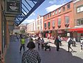
Central Harrow forms a commercial hub in the north-west of Greater London, with many retail outlets and commercial offices, and increasingly residential apartments in more recent regeneration schemes. Harrow is classified as one of 13 metropolitan centres in the London Plan.
The area has two shopping centres, St Anns and St George's, containing chain stores typical of British high streets. There are also parades of shops throughout Station Road and the ascending, traditional College Road, and over 300 metres (980 ft) of a fully pedestranised shopping/café streets roads (north of St Anns). A large Debenhams department store (174,000 square feet (16,200 m2) of floorspace) was on Station Road. After Debenhams was liquidated, the site is to become an independent department store called The Landmark due to open on 14 October 2021. There are also large Morrisons and Tesco superstores. As of 2012, Harrow has 1,128,050 square feet (104,799 m2) of total town centre floorspace, the lowest of London's metropolitan centres.
.jpg)
The creation of St George's in 1996, less than a decade after St Anns, gave Harrow a stronger competitive retail standing. On one index, the town centre's league position went from 106th (out of 1,000) to 71st (out of 1,400) from the mid-1980s to mid-1990s. Harrow's competing shopping centres were recognised to be Watford, Uxbridge and Brent Cross Shopping Centre. A 2003 council report showed that Harrow was less competitive as a retail centre by comparison.
In 2015, Harrow ranked 99th in the Hot 100 UK retail locations published by CACI; it was 5th in Greater London, behind Croydon, Kingston upon Thames, Bromley and Enfield Town. In 2018, Harrow was ranked 59th in the nationwide "High Street Investment Ranking" carried out by Knight Frank, and 6th in Greater London beaten by Uxbridge and Richmond.
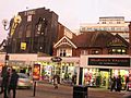
The Wealdstone district has a strong industrial connection, having been the location for the manufactures Winsor & Newton (artists' materials), Whitefriars Glass, and Kodak.
Education
.jpg)
Harrow is best known for Harrow School. An independent boarding school for boys, founded in 1572, Harrow School is considered one of the finest secondary schools in the world. The nearby John Lyon School is another boys' independent school, while another known school is the North London Collegiate School for girls located further in the borough in Edgware.
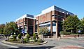
Harrow is also home to a large University of Westminster campus, located near Northwick Park and the hospital. It serves as the university's base for Media, Arts and Design. The school dates back to 1897 specialising in art, photography and fashion, becoming a college in the 1960s under the name Harrow College of Higher Education. It merged with Polytechnic of Central London (PCL) in 1990, now known as the University of Westminster.
Other educational institutes in or near central Harrow include: Harrow High School, Whitmore High School, St Dominic's Sixth Form College, Salvatorian College and Harrow College.
Greenhill School was built in the 1880s, but the building was demolished in 1967 to make way for shops on St Anns Road. The site is now home to a Marks & Spencer.
Notable people
Some notable people who were born and/or grew up in the Borough of Harrow are shown below.

.jpg)


Images for kids
-
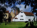
Grade I listed Headstone Manor
-
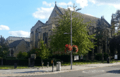
Grade II listed St John's Greenhill church originally served the hamlet of Greenhill - parts of the original building were demolished in 1905; today it is located in town on Sheepcote Road
-
Looking towards Grove Hill - behind the photographer was the scene of the 1899 car accident
-
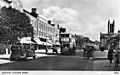
College Road, Harrow (c. 1937)
-
315 Station Road, Grade II listed building designed by Sir Banister Fletcher in 1915, which houses a NatWest bank today
-
Town centre pedestrianised in the 1980s (Havelock Place)
-
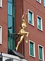
The golden woman sculpture on the Hygeia Building
-
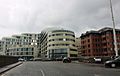
Bradstowe House, one of the 21st century developments
-
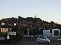
View of Harrow Hill and the spire of St Mary's Church from Bessborough Road, Harrow
-
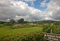
The Harrow School Farm looking north from Watford Road; St Mary's Church spire at the top of Harrow Hill is in the background
-

15 mile radius map from Harrow
-
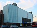
The former Granada Theatre, now a gymnasium
-
Safari Cinema
-
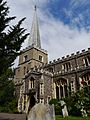
St Mary's Church on Harrow Hill
-
Harrow Crown Court
-
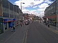
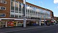
Station Road, Harrow
-
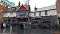
Royal Oak public house on St Anns Road has existed since the early 20th century and is locally listed
-
St Anns Road
-
St Anns Road
-
Middle section of Station Road, showing shops and the Time Building and apartments on Lyon Road behind it
-
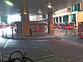
Harrow's central bus station
-
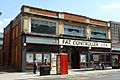
Former Fat Controller pub, closed in 2010
-
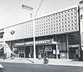
Premier Supermarket on Station Road (1963), now an Iceland supermarket; the site was originally home to the Harrow Coliseum cinema which was demolished in 1956
-
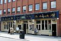
Moon on the Hill pub
-
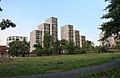
New built Harrow Square blocks
-
The old Debenhams shortly before its closure in May 2021. The site is becoming an independent department store called The Landmark.
-
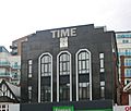
The Time Building on Station Road with a Miller-branded clock - formerly home of Time nightclub in 2000; today part converted into residential use


.jpg)

.jpg)

