
Hatteras, North Carolina facts for kids
Quick facts for kids
Hatteras, North Carolina
|
|
|---|---|

Location in Dare County and the state of North Carolina
|
|
| Country | United States of America |
| State | North Carolina |
| County | Dare |
| Named for | Hatteras Indians |
| Area | |
| • Total | 1.68 sq mi (4.36 km2) |
| • Land | 1.58 sq mi (4.08 km2) |
| • Water | 0.11 sq mi (0.29 km2) |
| Elevation | 3 ft (0.9 m) |
| Population
(2010)
|
|
| • Total | 504 |
| • Density | 320/sq mi (123.6/km2) |
| ZIP code |
27943
|
Hatteras is an unincorporated village and census-designated place (CDP) in Dare County, North Carolina, United States, on the Outer Banks island of Hatteras, at its extreme southwestern tip. As of the 2010 census it had a population of 504. Immediately to the west of the village of Hatteras is Hatteras Inlet which separates Hatteras Island from the neighboring Ocracoke Island. North Carolina Highway 12 passes through the community linking it to Frisco to the east and Ocracoke to the west (via a ferry across Hatteras Inlet).
The residents of Hatteras are governed by the Dare County Board of Commissioners. Hatteras is part of District 4, along with Avon, Buxton, Frisco, Rodanthe, Waves and Salvo.
Contents
Attractions and recreation
Hatteras is best known as a fishing and vacation destination. This community offers visitors ample opportunities for recreation, sightseeing, and remote relaxation especially on its beautiful beaches.
Watersports are plentiful on both the ocean-side and the sound-side of the village. Proximity to the convergence of the Labrador Current and the Gulf Stream result in the largest surf available on the East Coast. On the protected Pamlico Sound side of the island watersports such as windsurfing, kayaking, kiteboarding, and swimming are all readily available and accessible.
Fishing is a major source of recreation as well as revenue in Hatteras. In shore charters are available to fish in the Pamlico Sound. Deep sea charters are also available at Hatteras Harbor Marina and Oden's Dock. Deep sea trips take anglers to the warm waters of the Gulf Stream to fish for blue and white marlin, tuna, wahoo and mahi mahi. It takes approximately one and a half to two hours to reach the Gulf Stream from Hatteras Inlet.
Pamlico Sound, which separates Hatteras and Ocracoke Islands, is one of the largest estuarine systems in the world and offers an almost limitless variety of fishing opportunities.
Climate
| Climate data for Hatteras, North Carolina (1981–2010 normals), | |||||||||||||
|---|---|---|---|---|---|---|---|---|---|---|---|---|---|
| Month | Jan | Feb | Mar | Apr | May | Jun | Jul | Aug | Sep | Oct | Nov | Dec | Year |
| Average high °F (°C) | 54 (12) |
56 (13) |
61 (16) |
68 (20) |
75 (24) |
82 (28) |
86 (30) |
86 (30) |
82 (28) |
74 (23) |
65 (18) |
58 (14) |
71 (22) |
| Average low °F (°C) | 41 (5) |
43 (6) |
47 (8) |
55 (13) |
64 (18) |
71 (22) |
75 (24) |
75 (24) |
71 (22) |
63 (17) |
54 (12) |
46 (8) |
59 (15) |
| Source: NOAA (North Carolina Observed Climate Normals) | |||||||||||||
History
Hatteras was named after the Hatteras Indians.
Hatteras Village was cut off from the rest of the island on September 18, 2003, when Hurricane Isabel washed a 3,000 feet (910 m)* and 30-foot-deep (9.1 m) channel called Isabel Inlet at the north end of Hatteras village. The tear was subsequently repaired and restored by sand dredged by the Army Corps of Engineers.
The Ellsworth and Lovie Ballance House and Hatteras Weather Bureau Station are listed on the National Register of Historic Places.
Gallery
-
View of Pamlico Sound, near Hatteras Inlet from a home in Hatteras on a windy day in June 2007
-
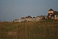
View of homes along oceanfront in Hatteras in June 2007
-

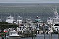
Busy Hatteras Ferry Lines on a Wednesday in June 2007
-
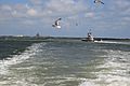
Ferries making trip from Ocracoke to Hatteras, June 2007
-
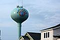
Water tower
-
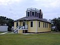
Historical US Weather Bureau office


Demographics
2020 census
| Race | Number | Percentage |
|---|---|---|
| White (non-Hispanic) | 540 | 93.59% |
| Black or African American (non-Hispanic) | 2 | 0.35% |
| Native American | 1 | 0.17% |
| Asian | 1 | 0.17% |
| Other/Mixed | 21 | 3.64% |
| Hispanic or Latino | 12 | 2.08% |
As of the 2020 United States census, there were 577 people, 207 households, and 130 families residing in the CDP.
Education
Residents are zoned to Dare County Schools. Zoned schools are Cape Hatteras Elementary School and Cape Hatteras Secondary School. The schools are located on NC 12 in Buxton.
Dare County Library has a branch in Hatteras.
Transportation
Hatteras is served by Billy Mitchell Airport.
The Village is also home to the Hatteras-Ocracoke Ferry terminal which is the only way for people to access Ocracoke Island from Hatteras Village other than air travel.
See also
 In Spanish: Hatteras (Carolina del Norte) para niños
