
Hawaii (island) facts for kids

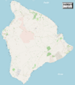
Landsat mosaic, 1999–2001
|
|
.svg)
Location in the state of Hawaii
|
|
| Geography | |
|---|---|
| Location | 19°34′N 155°30′W / 19.567°N 155.500°W |
| Archipelago | Hawaiian Islands |
| Area | 4,028 sq mi (10,430 km2) |
| Area rank | 75th largest island in the world; 1st largest island in the United States |
| Highest elevation | 13,803 ft (4,207.2 m) |
| Highest point | Mauna Kea |
| Administration | |
|
United States
|
|
| State | Hawaii |
| Symbols | |
| Flower | Red Pua Lehua (ʻOhiʻa blossom) |
| Color | ʻUlaʻula (red) |
| Largest settlement | Hilo |
| Demographics | |
| Population | 200,629 (2020) |
| Pop. density | 46 /sq mi (17.8 /km2) |
Hawaii ( Hawaiian: Hawaiʻi hə-WY-ee) is the largest island in the United States, located in the state of Hawaii. It is the southeasternmost of the Hawaiian Islands, a chain of volcanic islands in the North Pacific Ocean. With an area of 4,028 square miles (10,430 km2), it has 63% of the Hawaiian archipelago's combined landmass. However, it has only 13% of Hawaiʻi's population. The island of Hawaiʻi is the third largest island in Polynesia, behind the two main islands of New Zealand.
The island is often referred to as the Island of Hawaiʻi, the Big Island, or Hawaiʻi Island to distinguish it from the state. Administratively, the whole island is coextensive with Hawaii County.
As of the 2020 Census the population was 200,629 The county seat and largest city is Hilo. There are no incorporated cities in Hawaiʻi County (see List of counties in Hawaii).
Contents
History

Hawaiʻi is said to have been named after Hawaiʻiloa, the legendary Polynesian navigator who first discovered it. Other accounts attribute the name to the legendary realm of Hawaiki, a place from which the Polynesian people are said to have originated (see also Manua), the place where they go in the afterlife, the realm of the gods and goddesses. The name is cognate with Savaii, the name of the largest island of Samoa. Captain James Cook, the English explorer and navigator who was the captain of the first European expedition that discovered the Hawaiian Islands, called them the "Sandwich Islands" after his patron, the Earl of Sandwich. Cook was killed on the Big Island at Kealakekua Bay on 14 February 1779, in a mêlée which followed the theft of a ship's boat.
Hawaiʻi was the home island of Paiʻea Kamehameha, later known as Kamehameha the Great. Kamehameha united most of the Hawaiian islands under his rule in 1795, after several years of war, and gave the kingdom and the island chain the name of his native island.
Geology and geography

According to the U.S. Census Bureau, the county has a total area of 5,086 square miles (13,170 km2), of which 4,028 square miles (10,430 km2) is land and 1,058 square miles (2,740 km2) (20.8%) is water. The county's land area comprises 62.7 percent of the state's land area. It is the highest percentage by any county in the United States.
In greatest dimension, the island is 93 miles (150 km) across and has a land area of 4,028 square miles (10,430 km2) comprising 62% of the Hawaiian Islands' land area. Measured from its sea floor base to its highest peak, Mauna Kea is the world's tallest mountain, taller than Mount Everest is, since the base of Mount Everest is above sea level.

Volcanism


The Island of Hawaiʻi is built from five separate shield volcanoes that erupted somewhat sequentially, one overlapping the other. These are (from oldest to youngest):
Geological evidence from exposures of old surfaces on the south and west flanks of Mauna Loa led to the proposal that two ancient volcanic shields (named Ninole and Kulani) were all but buried by the younger Mauna Loa. Geologists now consider these "outcrops" to be part of the earlier building of Mauna Loa. Another volcano which has already disappeared below the surface of the ocean is Māhukona.
Because Mauna Loa and Kīlauea are active volcanoes, the island of Hawaii is still growing. Between January 1983 and September 2002, lava flows added 543 acres (220 ha) to the island. Lava flowing from Kīlauea has destroyed several towns, including Kapoho in 1960, and Kalapana and Kaimu in 1990. In 1987 lava filled in Queen's Bath, a large, L-shaped, freshwater pool in the Kalapana area.
The southmost point in the 50 States of the United States, Ka Lae, is on Hawaii. The nearest landfall to the south is in the Line Islands. To the north of the Island of Hawaii is the Island of Maui, whose Haleakala volcano is visible from Hawaii across the Alenuihaha Channel.
Approximately 35 km (22 mi) southeast of Hawaii lies the undersea volcano known as Loihi. Loihi is an erupting seamount that now reaches approximately 3,200 feet (980 m) below the surface of the ocean. Continued activity at current rates from Loihi will likely cause it to break the surface of the ocean sometime from 10,000 to 100,000 years from now.
Great Crack

The Great Crack is an eight-mile-long (13 km), 60-foot-wide (18 m) and 60-foot-deep (18 m)* fissure in the island, in the district of Kau. According to the United States Geological Survey (USGS), The Great Crack is the result of crustal dilation from magmatic intrusions into the southwest rift zone of Kilauea. While neither the earthquake of 1868 nor that of 1975 caused a measurable change in The Great Crack, lava welled out of the lower 6.2 miles (10 km) of the Great Crack in 1823.
Visitors can find trails, rock walls, and archaeological sites from as old as the 12th century around the Great Crack. Approximately 1,951 acres (790 ha) of private land were purchased during the Presidency of Bill Clinton, specifically to protect various artifacts in this area, as well as the habitat of local wildlife.
Hilina Slump

The Hilina Slump is a 4,760-cubic-mile (19,800 km3) chunk of the south slope of the Kīlauea volcano which is slipping away from the island. Between 1990 and 1993, Global Positioning System (GPS) measurements showed a southward displacement of about 3.9 inches (10 cm) per year. Undersea measurements show that a "bench" has formed a buttress and that this buttress may tend to reduce the likelihood of future catastrophic detachment.
Earthquakes and tsunamis


On 2 April 1868, an earthquake with a magnitude estimated between 7.25 and 7.9 on the Richter scale rocked the southeast coast of Hawaii. This was the most destructive earthquake in the recorded history of Hawaii. It triggered a landslide on Mauna Loa, five miles (8.0 km) north of Pahala, killing 31 people. A tsunami claimed 46 more lives. The villages of Punaluu, Ninole, Kawaa, Honuapo, and Keauhou Landing were severely damaged. The tsunami reportedly rolled over the tops of the coconut trees up to 60 feet (18 m) high, and it reached inland a distance of a quarter of a mile (400 meters) in some places.
On 29 November 1975, a 37-mile-wide (60 km) section of the Hilina Slump dropped 11.5 feet (3.5 m) and slid 26 feet (7.9 m) toward the ocean. This movement caused a 7.2 magnitude earthquake and a 48-foot-high (15 m)* tsunami. Oceanfront property was washed off its foundations in Punaluu. Two deaths were reported at Halape, and 19 other people were injured.
The island suffered tsunami damage from earthquakes in Alaska on 1 April 1946, and in Chile on 23 May 1960. Downtown Hilo was severely damaged by both tsunamis, with many lives lost. Just north of Hilo, Laupahoehoe lost 16 schoolchildren and five teachers in the tsunami of 1946.
In March 2011, a 9.0 magnitude earthquake off the east coast of Japan again created a tsunami that caused minor damage in Hawaii. The estimated damage to public buildings alone was about US$3 million. In the Kona area this tsunami washed a house into Kealakekua Bay, destroyed a yacht club and tour boat offices in Keauhou Bay, caused extensive damage in Kailua Kona, flooded the ground floor of the King Kamehameha Hotel, and permanently closed the Kona Village Resort.
Volcanic fog
Vog (volcanic fog) can envelop the island. The gas plumes of the Kīlauea Volcano create a blanket of vog which the dominant trade winds mostly deflect toward the Kona coast on the west side of the Island of Hawaiʻi. Vog contains chemicals that can damage the environment, and the health of plants, humans, and other animals. Most of the aerosols are acidic and of a size where they can remain in the lungs to damage the lungs and impair function. Flu-like symptoms and general lethargy are reported, especially pronounced in people with respiratory conditions.
National protected areas

- Ala Kahakai National Historic Trail
- Hakalau Forest National Wildlife Refuge
- Hawaiʻi Volcanoes National Park
- Honokōhau Settlement and Kaloko-Honokōhau National Historical Park
- Kohala Historical Sites State Monument (Mookini Heiau)
- Kona Forest National Wildlife Refuge
- Puʻuhonua o Hōnaunau National Historical Park
- Puʻukoholā Heiau National Historic Site
Adjacent counties
- Maui County – northwest
Demographics
| Historical population | |||
|---|---|---|---|
| Census | Pop. | %± | |
| 1900 | 46,843 | — | |
| 1910 | 55,382 | 18.2% | |
| 1920 | 64,895 | 17.2% | |
| 1930 | 73,325 | 13.0% | |
| 1940 | 73,276 | −0.1% | |
| 1950 | 68,350 | −6.7% | |
| 1960 | 61,332 | −10.3% | |
| 1970 | 63,468 | 3.5% | |
| 1980 | 92,053 | 45.0% | |
| 1990 | 120,317 | 30.7% | |
| 2000 | 148,677 | 23.6% | |
| 2010 | 185,079 | 24.5% | |
| 2013 (est.) | 190,821 | 3.1% | |
|
U.S. Decennial Census
1790–1960 1900–1990 1990–2000 2010–2013 |
|||
As of the census of 2010, the island had a resident population of 185,079. There were 64,382 households in the county. The population density was 17.7/km2 (45.9/mi2). There were 82,324 housing units at an average density of 8/km2 (20/mi2). The racial makeup of the county was 34.5% White, 0.7% African American, 22.6% Asian, 12.4% Native Hawaiian or other Pacific Islander, and 29.2% from two or more races; 11.8% of the population were Hispanics or Latinos of any race.
There were 64,382 households out of which 32.20% had children under the age of 18 living with them, 50.60% were married couples living together, 13.20% had a woman whose husband did not live with her, and 30.40% were non-families. 23.10% of all households were made up of individuals and 8.00% had someone living alone who was 65 years of age or older. The average household size was 2.75 and the average family size was 3.24.
The age distribution was 26.10% under 18, 8.20% from 18 to 24, 26.20% from 25 to 44, 26.00% from 45 to 64, and 13.50% who were 65 or older. The median age was 39 years. For every 100 females there were 100 males. For every 100 females age 18 and over, there were 98 males.
41.31% of the people in Hawaii, Hawaii are religious, meaning they affiliate with a religion. 18.38% are Catholic; 3.70% are another Christian faith; 5.14% are LDS; 0.06% in Hawaii, Hawaii are Jewish; 5.04% are an eastern faith; 0.05% affilitates with Islam.
-
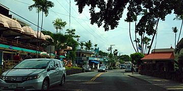
Downtown Kona, Hawaii
-
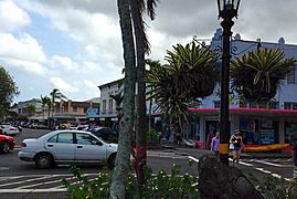
Downtown Hilo, Hawaii


Transportation

Roads
Three routes connect the two major towns, Hilo on the east coast and Kailua-Kona on the west coast of the island:
- State highways 19 & 190, the northern route via Waimea
- State highway 11, the southern route via Hawaiʻi Volcanoes National Park
- Saddle Road (aka the Daniel K. Inouye Memorial highway), passing between Mauna Loa and Mauna Kea).
There are also State highways 270 (Kawaihae – Hawi) and 180 (the "Kona coffee road", from Honalo to State highway 190), South Point Road (Highway 11 to South Point), etc.
There are presently three Hawaii Scenic Byways on the island of Hawaii:
- Mamalahoa Kona Heritage Center
- Royal Footsteps Along the Kona Coast
- Kaʻu Scenic Byway – The Slopes of Mauna Loa
Rental car offices are at the international airports. Taxi service is also available. Island-wide bus service is provided by the "Hele-On Bus".
Airports
Two commercial airports serve Hawaiʻi Island:
- Hilo International Airport (ITO)
- Kona International Airport (KOA)
There is also:
- Waimea-Kohala Airport (MUE)
- Upolu Airport (UPP)
Seaports
Major commercial ports are Hilo on the east side and Kawaihae on the west side of the island. Cruise ships often stop at Kailua-Kona (90 times in 2017) and Hilo (108 times in 2017).

Places of interest

- Akaka Falls; one of the taller waterfalls on the island.
- Amy B. H. Greenwell Ethnobotanical Garden houses many endangered endemic plants.
- East Hawaiʻi Cultural Center
- Hawaiʻi Tropical Botanical Garden
- Hawaiʻi Volcanoes National Park; comprising the active volcanoes Kīlauea and Mauna Loa
- Huliheʻe Palace; a royal palace in Kailua-Kona
- ʻImiloa Astronomy Center of Hawaiʻi in Hilo
- Ka Lae, the southernmost point in the United States
- Laupahoehoe Train Museum
- Lyman House Memorial Museum in Hilo
- Manuka State Wayside Park
- Mauna Kea Observatory; Mauna Kea Observatories
- Nani Mau Gardens
- Onizuka Center for International Astronomy
- Pacific Tsunami Museum overlooking Hilo Bay
- Pana'ewa Rainforest Zoo in Hilo
- Pua Mau Place Arboretum and Botanical Garden
- Puʻuhonua o Hōnaunau National Historical Park
- Pu'ukohola Heiau National Historic Site, the site of one of the most significant heiau in Hawaii.
- Rainbow Falls State Park
- Sadie Seymour Botanical Gardens
- Umauma Falls
- University of Hawaiʻi at Hilo Botanical Gardens
- World Botanical Gardens
- Waipiʻo Valley
- Wao Kele o Puna
Maps
-
National parks, mountains and cities on the island
-
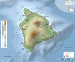
Topographical map of the island of Hawaii
(interactive 3D model for Chrome or Firefox)


Communities
The island was traditionally divided into districts called moku. The names of the districts are (counter-clockwise, from the southeast): Puna, Hilo, Hāmākua, Kohala, Kona, and Kaʻū. The county government subdivides some of these to form elective districts of the county council. There are no incorporated municipalities on the island.
Census-designated places

- Ainaloa
- Captain Cook
- Eden Roc
- Fern Acres
- Fern Forest
- Halaula
- Hawaiian Acres
- Hawaiian Beaches
- Hawaiian Ocean View
- Hawaiian Paradise Park
- Hawi
- Hilo
- Holualoa
- Honalo
- Honaunau-Napoopoo
- Honokaa
- Honomu
- Kahaluu-Keauhou
- Kailua
- Kalaoa
- Kapaau
- Keaau
- Kealakekua
- Keokea
- Kukuihaele
- Kurtistown
- Laupahoehoe
- Leilani Estates
- Mountain View
- Naalehu
- Nanawale Estates
- Orchidlands Estates
- Paauilo
- Pahala
- Pahoa
- Papaikou
- Pepeekeo
- Paukaa
- Puako
- Volcano
- Waikoloa Village
- Waimea
- Wainaku
Unincorporated communities
Images for kids
-
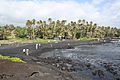
Punaluʻu Black Sand Beach Park
-
Laʻaloa Bay, also known as "Magic Sands," located in Kailua-Kona
-
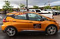
Mobile atmospheric volcanic fog measuring station in Hawaii
-
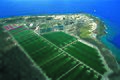
Aerial view of Cyanotech Corp. microalgae ponds at NELHA
-
National parks, mountains and cities on the island
-
Detailed map of the island of Hawaii
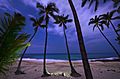
_Hawaii_Christmas.jpg)
.jpg)


See also
 In Spanish: Isla de Hawái para niños
