Hawleyville, Connecticut facts for kids
Quick facts for kids
Hawleyville, Connecticut
|
|
|---|---|

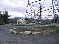
The Hawleyville Deli lies along Route 25 where it crosses the Housatonic Railroad.
|
|
| Country | |
| U.S. state | |
| County | Fairfield |
| Metropolitan area | Bridgeport-Stamford |
| Town | Newtown |
| Time zone | UTC−5 (Eastern) |
| • Summer (DST) | UTC−4 (EDT) |
| ZIP code |
06440-9992
|
| Area code(s) | 203/475 |
Hawleyville is an unincorporated community in Fairfield County in the town of Newtown, Connecticut, about 1 mile outside the borough of Newtown. It was listed as a census-designated place prior to the 2020 census.
History
In early history, the village of Hawleyville briefly emerged as a railroad center, causing the town - Newtown's - population to grow over 4,000 circa 1881. The railroads included the New York and New England Railroad and the Hawleyville Branch of the Danbury and Norwalk Railroad.

All content from Kiddle encyclopedia articles (including the article images and facts) can be freely used under Attribution-ShareAlike license, unless stated otherwise. Cite this article:
Hawleyville, Connecticut Facts for Kids. Kiddle Encyclopedia.
