Helmetta, New Jersey facts for kids
Quick facts for kids
Helmetta, New Jersey
|
|
|---|---|
|
Borough
|
|
| Borough of Helmetta | |
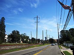
Looking north along Main Street (CR 615)
|
|
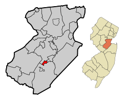
Helmetta highlighted in Middlesex County. Inset: Location of Middlesex County highlighted in the State of New Jersey.
|
|
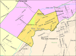
Census Bureau map of Helmetta, New Jersey
|
|
| Country | |
| State | |
| County | Middlesex |
| Incorporated | March 20, 1888 |
| Named for | Olivia Antoinette "Etta" Helme |
| Government | |
| • Type | Borough |
| • Body | Borough Council |
| Area | |
| • Total | 0.88 sq mi (2.27 km2) |
| • Land | 0.83 sq mi (2.15 km2) |
| • Water | 0.05 sq mi (0.13 km2) 5.57% |
| Area rank | 519th of 565 in state 25th of 25 in county |
| Elevation | 59 ft (18 m) |
| Population | |
| • Total | 2,178 |
| • Estimate
(2019)
|
2,155 |
| • Rank | 480th of 566 in state 25th of 25 in county |
| • Density | 2,562.9/sq mi (989.5/km2) |
| • Density rank | 241st of 566 in state 19th of 25 in county |
| Time zone | UTC−05:00 (Eastern (EST)) |
| • Summer (DST) | UTC−04:00 (Eastern (EDT)) |
| ZIP Code |
08828
|
| Area code(s) | 732 Exchange: 521 |
| FIPS code | 3402330840 |
| GNIS feature ID | 885250 |
| Website | |
Helmetta is a borough in Middlesex County, New Jersey, United States. The borough is nestled within the heart of the Raritan Valley region, with Manalapan Brook (a Raritan River tributary) flowing through the center of the community. As of the 2010 United States Census, the borough's population was 2,178, reflecting an increase of 353 (+19.3%) from the 1,825 counted in the 2000 Census, which had in turn increased by 614 (+50.7%) from the 1,211 counted in the 1990 Census. The community was established around a snuff mill opened in the 1820s that was acquired by George Washington Helme in the 1880s.
Helmetta was formed as a borough by an act of the New Jersey Legislature on March 20, 1888, when it was created from portions of East Brunswick, based on the results of a referendum held on March 10, 1888. Helmetta's boundary with East Brunswick Township was changed as of March 24, 1897. The borough was named for Helme's daughter, Olivia Antoinette "Etta" Helme.
Contents
History
G. W. Helme Snuff Mill District
|
G. W. Helme Snuff Mill District
|
|
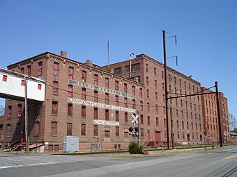
The Helmetta Snuff Mill in Spring 2012
|
|
| Location | Main Street Helmetta, New Jersey |
|---|---|
| NRHP reference No. | 79001511 |
| Significant dates | |
| Added to NRHP | August 15, 1980 |
Helmetta's main landmark is the large, abandoned Helme Products Inc. plant that sits adjacent to the Camden and Amboy Railroad line running through town (map showing Helmetta on a Camden and Amboy Railroad route). The mill began producing snuff in the 1880s. On February 23, 1900, the mill was bought by the American-Sniff Company in a merger with Helme Products Inc., but the merger was dissolved in 1911. In 1925, the mill became the largest of its kind in the world, and by 1934 it employed 400 people. In 1986, the mill was bought out by American Maize-Products. Finally, in 1993, it was purchased by Swisher International, and operations were moved to Wheeling, West Virginia. It has remained inactive since.
The G. W. Helme Snuff Mill District is a classic example of a late 1800s mill town. The district consists of the George Washington Helme snuff mill, housing for employees, accessory buildings, St. George Episcopal Church, Holy Trinity Roman Catholic Church, and Helmetta Pond, which at one time served as a source of power for the mill. About 115 buildings were originally in the district, which was named to the New Jersey Register of Historic Places on February 1, 1980, and to the National Register of Historic Places listings in Middlesex County, New Jersey on August 15, 1980.
Geography
According to the United States Census Bureau, the borough had a total area of 0.907 square miles (2.349 km2), including 0.850 square miles (2.201 km2) of land and 0.057 square miles (0.148 km2) of water (6.32%).
The borough borders the Middlesex County municipalities of East Brunswick Township, Monroe Township and Spotswood.
Demographics
| Historical population | |||
|---|---|---|---|
| Census | Pop. | %± | |
| 1900 | 447 | — | |
| 1910 | 661 | 47.9% | |
| 1920 | 687 | 3.9% | |
| 1930 | 801 | 16.6% | |
| 1940 | 667 | −16.7% | |
| 1950 | 580 | −13.0% | |
| 1960 | 779 | 34.3% | |
| 1970 | 955 | 22.6% | |
| 1980 | 955 | 0.0% | |
| 1990 | 1,211 | 26.8% | |
| 2000 | 1,825 | 50.7% | |
| 2010 | 2,178 | 19.3% | |
| 2019 (est.) | 2,155 | −1.1% | |
| Population sources: 1900-1920 1900-1910 1910-1930 1930-1990 2000 2010 |
|||
Census 2010
As of the census of 2010, there were 2,178 people, 891 households, and 596 families residing in the borough. The population density was 2,562.9 per square mile (989.5/km2). There were 920 housing units at an average density of 1,082.6 per square mile (418.0/km2)*. The racial makeup of the borough was 88.61% (1,930) White, 3.95% (86) Black or African American, 0.09% (2) Native American, 4.87% (106) Asian, 0.00% (0) Pacific Islander, 1.15% (25) from other races, and 1.33% (29) from two or more races. [[Hispanic (U.S. Census)|Hispanic or Latino of any race were 7.53% (164) of the population.
There were 891 households out of which 27.8% had children under the age of 18 living with them, 52.5% were married couples living together, 10.4% had a female householder with no husband present, and 33.1% were non-families. 26.0% of all households were made up of individuals, and 5.3% had someone living alone who was 65 years of age or older. The average household size was 2.44 and the average family size was 2.97.
In the borough, the population was spread out with 20.8% under the age of 18, 7.1% from 18 to 24, 31.7% from 25 to 44, 30.8% from 45 to 64, and 9.6% who were 65 years of age or older. The median age was 40.3 years. For every 100 females there were 93.6 males. For every 100 females ages 18 and old there were 90.2 males.
The Census Bureau's 2006-2010 American Community Survey showed that (in 2010 inflation-adjusted dollars) median household income was $80,690 (with a margin of error of +/- $4,944) and the median family income was $96,875 (+/- $8,073). Males had a median income of $63,625 (+/- $7,838) versus $48,333 (+/- $6,040) for females. The per capita income for the borough was $36,941 (+/- $2,537). About 3.4% of families and 3.7% of the population were below the poverty line, including 5.8% of those under age 18 and 3.2% of those age 65 or over.
Census 2000
As of the 2000 United States Census there were 1,825 people, 746 households, and 495 families residing in the borough. The population density was 2,153.6 people per square mile (829.0/km2). There were 769 housing units at an average density of 907.5 per square mile (349.3/km2). The racial makeup of the borough was 93.15% White, 2.41% African American, 0.22% Native American, 2.41% Asian, 0.05% Pacific Islander, 0.88% from other races, and 0.88% from two or more races. Hispanic or Latino of any race were 5.32% of the population.
There were 746 households, out of which 33.0% had children under the age of 18 living with them, 54.7% were married couples living together, 8.4% had a female householder with no husband present, and 33.6% were non-families. 25.6% of all households were made up of individuals, and 5.1% had someone living alone who was 65 years of age or older. The average household size was 2.45 and the average family size was 3.01.
In the borough the population was spread out, with 22.1% under the age of 18, 6.5% from 18 to 24, 44.1% from 25 to 44, 21.2% from 45 to 64, and 6.2% who were 65 years of age or older. The median age was 36 years. For every 100 females, there were 98.4 males. For every 100 females age 18 and over, there were 97.2 males.
The median income for a household in the borough was $60,125, and the median income for a family was $64,659. Males had a median income of $47,604 versus $33,929 for females. The per capita income for the borough was $26,668. About 3.2% of families and 3.3% of the population were below the poverty line, including 5.2% of those under age 18 and 1.8% of those age 65 or over.
Transportation
Roads and highways
As of May 2010[update], the borough had a total of 8.79 miles (14.15 km) of roadways, of which 7.28 miles (11.72 km) were maintained by the municipality and 1.51 miles (2.43 km) by Middlesex County.
The major thoroughfare in the borough is Main Street (County Route 615) which connects with Monroe to the southwest and Spotswood to the northeast. Main Street is largely known as Bordentown-Amboy Turnpike between Jamesburg and South Amboy.
The New Jersey Turnpike (Interstate 95) is accessible at Exit 8A in neighboring Monroe Township.
An analysis of speeding tickets issued over an 18-month period between 2011 and 2013 showed that 222 tickets were issued in that timeframe with only two given to borough residents, which was cited as supporting claims that the borough's police department is unfairly targeting non-residents.
Public transportation
Middlesex County Area Transit (MCAT) shuttles provide service to and from Helmetta on routes operating across the county. The M2 Route connects Jamesburg, Helmetta and Spotswood with East Brunswick including the Brunswick Square Mall.
Education
All public school students from Helmetta attend the Spotswood Public Schools, with the districts having been consolidated after a July 2009 decision by the New Jersey Department of Education that merged Helmetta into the Spotswood district. Students from Milltown attend the high school as part of a sending/receiving relationship with the Milltown Public Schools.
The Spotswood Public Schools serves students in pre-kindergarten through twelfth grade. As of the 2017–18 school year, the district, comprised of four schools, had an enrollment of 1,740 students and 140.1 classroom teachers (on an FTE basis), for a student–teacher ratio of 12.4:1. Schools in the district (with 2017-18 enrollment data from the National Center for Education Statistics) are G. Austin Schoenly Elementary School (235 students; in grades PreK-1), E. Raymond Appleby Elementary School (442; 2-5), Spotswood Memorial Middle School (362; 6-8) and Spotswood High School (679; 9-12).
Eighth grade students from all of Middlesex County are eligible to apply to attend the high school programs offered by the Middlesex County Vocational and Technical Schools, a county-wide vocational school district that offers full-time career and technical education at Middlesex County Academy in Edison, the Academy for Allied Health and Biomedical Sciences in Woodbridge Township and at its East Brunswick, Perth Amboy and Piscataway technical high schools, with no tuition charged to students for attendance.
See also
 In Spanish: Helmetta para niños


