
Herkimer (town), New York facts for kids
Quick facts for kids
Herkimer, New York
|
|
|---|---|

North Main Street
|
|

Location of Herkimer within Herkimer County
|
|

Herkimer, New York
Location in New York

Herkimer, New York
Location in the United States
|
|
| Country | United States |
| State | New York |
| County | Herkimer |
| Area | |
| • Total | 32.23 sq mi (83.47 km2) |
| • Land | 31.66 sq mi (82.00 km2) |
| • Water | 0.57 sq mi (1.47 km2) |
| Population
(2010)
|
|
| • Total | 10,175 |
| • Estimate
(2016)
|
9,822 |
| • Density | 310.21/sq mi (119.78/km2) |
| Time zone | EST |
| • Summer (DST) | EDT |
| ZIP code |
13350
|
| Area code(s) | 315 |
| FIPS code | 36-043-34132 |
Herkimer is a town in Herkimer County, New York, United States, southeast of Utica. It is named after Nicholas Herkimer. The population was 10,175 at the 2010 census.
The town contains a village also called Herkimer. Herkimer County Community College is located in Herkimer village.
Contents
History
Herkimer was first settled around 1722, in an area originally called Stone Ridge, now the Village of Herkimer. Early settlers were primarily Palatine Germans.
Johan Jost Herchheimer, a farmer who also engaged in trade and transport on the Mohawk River, settled in the German Flatts District of Albany County, New York in 1725, on the south side of the Mohawk River, within the present day township of German Flatts, incorporated in 1788. He owned 5,000 acres (20 km2) of the land, including a strategic portage around Little Falls, where his eldest son Nicholas Herkimer established a farmstead. In 1788, the town of Herkimer, on the north side of the river, was incorporated and named after him.
During the French and Indian War, the Mohawk Valley was ravaged by raids of the French and their native allies. By 1770, Nicholas had established great wealth through farming and trade during the wars, and had also gained military experience as a captain of a Militia. He would later fight in the Battle of Oriskany.
The Town of Herkimer was established in 1789.
Geography
According to the United States Census Bureau, the town has a total area of 32.1 square miles (83.2 km²). Land comprises 31.6 square miles (81.7 km²) of the town and 0.6 square miles (1.5 km²) of the town (1.74%) is water.
The West Canada Creek empties into the Mohawk River by Herkimer village. On the opposite shore of the Mohawk River is the Village of Mohawk and the Village of Ilion.
The New York State Thruway and New York State Route 5 run through the south part of the town. New York State Route 28 is a north-south highway that intersects NY-5 in Herkimer village.
Demographics

| Historical population | |||
|---|---|---|---|
| Census | Pop. | %± | |
| 1820 | 3,055 | — | |
| 1830 | 2,486 | −18.6% | |
| 1840 | 2,369 | −4.7% | |
| 1850 | 2,601 | 9.8% | |
| 1860 | 2,804 | 7.8% | |
| 1870 | 2,949 | 5.2% | |
| 1880 | 3,593 | 21.8% | |
| 1890 | 4,666 | 29.9% | |
| 1900 | 6,748 | 44.6% | |
| 1910 | 8,797 | 30.4% | |
| 1920 | 11,982 | 36.2% | |
| 1930 | 12,327 | 2.9% | |
| 1940 | 11,345 | −8.0% | |
| 1950 | 11,235 | −1.0% | |
| 1960 | 11,568 | 3.0% | |
| 1970 | 11,451 | −1.0% | |
| 1980 | 11,027 | −3.7% | |
| 1990 | 10,401 | −5.7% | |
| 2000 | 9,961 | −4.2% | |
| 2010 | 10,175 | 2.1% | |
| 2016 (est.) | 9,822 | −3.5% | |
| U.S. Decennial Census | |||
As of the census of 2000, there were 9,962 people, 4,114 households, and 2,386 families residing in the town. The population density was 315.6 people per square mile (121.9/km2). There were 4,513 housing units at an average density of 143.0 per square mile (55.2/km2). The racial makeup of the town was 96.83% White, 0.97% Black or African American, 0.18% Native American, 1.03% Asian, 0.01% Pacific Islander, 0.41% from other races, and 0.56% from two or more races. Hispanic or Latino of any race were 1.17% of the population.
There were 4,114 households, out of which 25.3% had children under the age of 18 living with them, 42.8% were married couples living together, 10.7% had a female householder with no husband present, and 42.0% were non-families. 32.0% of all households were made up of individuals, and 16.5% had someone living alone who was 65 years of age or older. The average household size was 2.29 and the average family size was 2.90.
In the town, the population was spread out, with 20.2% under the age of 18, 12.9% from 18 to 24, 23.0% from 25 to 44, 22.2% from 45 to 64, and 21.8% who were 65 years of age or older. The median age was 40 years. For every 100 females, there were 89.5 males. For every 100 females age 18 and over, there were 87.1 males.
The median income for a household in the town was $28,763, and the median income for a family was $42,296. Males had a median income of $30,828 versus $20,845 for females. The per capita income for the town was $17,211. About 7.9% of families and 13.3% of the population were below the poverty line, including 8.9% of those under age 18 and 10.9% of those age 65 or over.
Communities and locations in the Town of Herkimer, NY
- Beacon Light Corners – A location near the west town line.
- East Herkimer – A hamlet east of Herkimer village on NY-5.
- Eatonville – A hamlet near the northeast corner of the town.
- Herkimer – The Village of Herkimer is by the south town line, on NY-5 by the Mohawk River.
- Kast Bridge – A hamlet north of Herkimer village on NY-28.
- Mirror Lake – A small lake north of Herkimer village.
- Herkimer Home, State Historical Site - Little Falls, NY
Images for kids
-
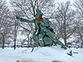
Statue of Nicholas Herkimer in Myers Park
-
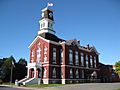
Herkimer County Courthouse


See also
 In Spanish: Herkimer (Nueva York) para niños
