
Highland Boundary Fault facts for kids
_Named_(HR).png)
The Highland Boundary Fault is a geological fault that crosses Scotland diagonally from Arran and Helensburgh on the west coast to Stonehaven in the east. It separates two distinctly different regions: the Highlands from the Lowlands.
The geological history of Scotland can be understood as the result of two great tectonic events. The first was the formation of the global super-continent Pangaea, the second was the break-up of Pangaea to form the continents we know today.
The fault is the middle of three great faults which run from the south-west to the north-east across Scotland. In the north there is the Great Glen Fault, and in the south the Southern Uplands Fault. Further south, just over the border with England, is the Iapetus Suture, where the palaeo-Iapetus Ocean closed. These four major geological signs mark the ancient history of Scotland.


The Highland Boundary Fault was active during the Caledonian orogeny. This was a plate tectonic collision which took place from Mid Ordovician to Mid Devonian periods (520 to 400 million years ago), during the closure of the Iapetus Ocean.
The fault allowed the Midland Valley to descend as a major rift by up to 4000 metres and there was subsequently vertical movement. This movement was later replaced by a horizontal shear. A complementary fault, the Southern Uplands Fault, forms the southern boundary for the Central Lowlands.

Images for kids
-
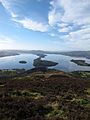
View along the Highland Boundary Fault from Conic Hill – the topographic ridge is mainly due to the presence of Devonian age conglomerates on the southwestern side of the fault and can be traced across Loch Lomond on the islands of Inchcailloch, Torrinch, Creinch and Inchmurrin, to Ben Bowie on the western shore
-
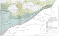
Map published in 1912 by George Barrow showing what became known as the Highland Boundary Fault
-
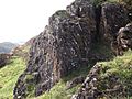
Altered serpentinite and associated sediments of the Highland Border Complex caught up in the fault zone – exposed on Druim nam Buraich, near Balmaha
-

Lower Devonian sandstones and conglomerates of the Inchmurrin Member dipping steeply to the southeast close to the Highland Boundary Fault trace near Balmaha


See also
 In Spanish: Falla de las Highlands para niños
