
Hinterrhein, Switzerland facts for kids
Quick facts for kids
Hinterrhein
|
||
|---|---|---|
|
||
| Country | Switzerland | |
| Canton | Graubünden | |
| District | Hinterrhein | |
| Area | ||
| • Total | 48.3 km2 (18.6 sq mi) | |
| Elevation
(Kirche Hinterrhein)
|
1,620 m (5,310 ft) | |
| Population
(Dec 2015)
|
||
| • Total | 66 | |
| • Density | 1.366/km2 (3.539/sq mi) | |
| Postal code |
7438
|
|
| Surrounded by | Blenio (TI), Malvaglia (TI), Mesocco, Nufenen, Vals | |

Hinterrhein (Romansh: Valragn) was a municipality in Hinterrhein in the canton of Graubünden in Switzerland. On 1 January 2019 the municipalities Hinterrhein, Nufenen and Splügen joined together to become the new municipality called Rheinwald.

Images for kids
-
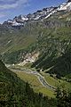
The river Hinterrhein near Hinterrhein

See also
 In Spanish: Hinterrhein para niños

All content from Kiddle encyclopedia articles (including the article images and facts) can be freely used under Attribution-ShareAlike license, unless stated otherwise. Cite this article:
Hinterrhein, Switzerland Facts for Kids. Kiddle Encyclopedia.