
Alpine County, California facts for kids
Quick facts for kids
Alpine County, California
|
|||
|---|---|---|---|
| Alpine County Spanish: Condado Alpino |
|||
 .jpg)  Images, from top down, left to right: an Alpine County line road sign during a snow storm, Alpine County Courthouse, a view eastward from Carson Pass overlooking Red Lake
|
|||
|
|||

Location in the state of California
|
|||
| Country | |||
| State | |||
| Region | Sierra Nevada | ||
| Incorporated | March 16, 1864 | ||
| Named for | Its location in the Sierra Nevada resembling the (Swiss) Alps | ||
| County seat | Markleeville | ||
| Largest community | Markleeville | ||
| Area | |||
| • Total | 743 sq mi (1,920 km2) | ||
| • Land | 738 sq mi (1,910 km2) | ||
| • Water | 4.8 sq mi (12 km2) | ||
| Highest elevation | 11,464 ft (3,494 m) | ||
| Population
(2020)
|
|||
| • Total | 1,204 | ||
| • Density | 1.6205/sq mi (0.6257/km2) | ||
| Time zone | UTC−8 (Pacific Standard Time) | ||
| • Summer (DST) | UTC−7 (Pacific Daylight Time) | ||
| Area codes | 209, 530 | ||
| FIPS code | 06-003 | ||
| GNIS feature ID | 1675840 | ||


Alpine County (Spanish: Condado Alpino) is a county in Eastern California located within the Sierra Nevada on the state border with Nevada. As of the 2020 Census, the population was 1,204, making it California's least populous county. The county seat and largest community is Markleeville.
Contents
History

Alpine County was created on March 16, 1864, during a silver boom in the wake of the nearby Comstock Lode discovery. It was named because of its resemblance to the Swiss Alps. The County was formed from parts of Amador, Calaveras, El Dorado, Mono and Tuolumne Counties. At its formation, the County had a population of about 11,000 with its County Seat at Silver Mountain City. By 1868, however, the local silver mines had proven unfruitful; and the population fell to about 1,200. The County Seat was moved to Markleeville in 1875.
After the silver rush, Alpine County's economy consisted almost entirely of farming, ranching, and logging. By the 1920s, the population had fallen to just 200 people. With the construction of the Bear Valley and Kirkwood ski resorts in the late 1960s, the population increased to the present level.
Geography
According to the U.S. Census Bureau, the county has an area of 743 square miles (1,920 km2), of which 738 square miles (1,910 km2) is land and 4.8 square miles (12 km2) (0.7%) is water. The federal government owns about 96% of Alpine County, the highest percentage in California.
National protected areas
- Eldorado National Forest (part)
- Stanislaus National Forest (part)
- Toiyabe National Forest (part)
Demographics
| Historical population | |||
|---|---|---|---|
| Census | Pop. | %± | |
| 1870 | 685 | — | |
| 1880 | 539 | −21.3% | |
| 1890 | 667 | 23.7% | |
| 1900 | 509 | −23.7% | |
| 1910 | 309 | −39.3% | |
| 1920 | 243 | −21.4% | |
| 1930 | 241 | −0.8% | |
| 1940 | 323 | 34.0% | |
| 1950 | 241 | −25.4% | |
| 1960 | 397 | 64.7% | |
| 1970 | 484 | 21.9% | |
| 1980 | 1,097 | 126.7% | |
| 1990 | 1,113 | 1.5% | |
| 2000 | 1,208 | 8.5% | |
| 2010 | 1,175 | −2.7% | |
| 2020 | 1,204 | 2.5% | |
| U.S. Decennial Census 1790–1960 1900–1990 1990–2000 2010 2020 |
|||
2020 census
| Race / Ethnicity | Pop 2010 | Pop 2020 | % 2010 | % 2020 |
|---|---|---|---|---|
| White alone (NH) | 852 | 801 | 72.51% | 66.53% |
| Black or African American alone (NH) | 0 | 10 | 0.00% | 0.83% |
| Native American or Alaska Native alone (NH) | 210 | 214 | 17.87% | 17.77% |
| Asian alone (NH) | 7 | 12 | 0.60% | 1.00% |
| Pacific Islander alone (NH) | 0 | 0 | 0.00% | 0.00% |
| Some Other Race alone (NH) | 1 | 7 | 0.09% | 0.58% |
| Mixed Race/Multi-Racial (NH) | 21 | 76 | 1.79% | 6.31% |
| Hispanic or Latino (any race) | 84 | 84 | 7.15% | 6.98% |
| Total | 1,175 | 1,204 | 100.00% | 100.00% |
Note: the US Census treats Hispanic/Latino as an ethnic category. This table excludes Latinos from the racial categories and assigns them to a separate category. Hispanics/Latinos can be of any race.
2019 American Community Survey estimates
| Population | ||
|---|---|---|
| Group | Estimate | Percent |
| Total population | 1,039 | |
| Sex | ||
| Group | Estimate | Percent |
| Male | 554 | 53.32% |
| Female | 485 | 46.68% |
| Sex ratio (males per 100 females) | 92.8 | 114.2 |
| Age | ||
| Group | Estimate | Percent |
| Under 5 years | 44 | 4.23% |
| 5 to 9 years | 50 | 4.81% |
| 10 to 14 years | 73 | 7.03% |
| 15 to 19 years | 59 | 5.68% |
| 20 to 24 years | 43 | 4.14% |
| 25 to 29 years | 21 | 2.02% |
| 30 to 34 years | 45 | 4.33% |
| 35 to 39 years | 86 | 8.28% |
| 40 to 44 years | 62 | 5.97% |
| 45 to 49 years | 13 | 1.25% |
| 50 to 54 years | 43 | 4.14% |
| 55 to 59 years | 73 | 7.03% |
| 60 to 64 years | 116 | 11.16% |
| 65 to 69 years | 97 | 9.34% |
| 70 to 74 years | 133 | 12.80% |
| 75 to 79 years | 54 | 5.20% |
| 80 to 84 years | 4 | 0.38% |
| 85 years and over | 23 | 2.21% |
| Median age (years) | 52.2 | |
| Age dependency ratio | 97.2 | |
| Old-age dependency ratio | 59.0 | |
| Child dependency ratio | 38.1 | |
| Race | ||
| Group | Estimate | Percent |
| White | 599 | 57.65% |
| Black or African American | 9 | 0.87% |
| American Indian or Alaska Native | 353 | 33.97% |
| --- Cherokee tribal grouping | 0 | 0.00% |
| --- Chippewa tribal grouping | 0 | 0.00% |
| --- Navajo tribal grouping | 0 | 0.00% |
| --- Sioux tribal grouping | 0 | 0.00% |
| Asian | 10 | 0.96% |
| --- Asian Indian | 0 | 0.00% |
| --- Chinese | 0 | 0.00% |
| --- Filipino | 0 | 0.00% |
| --- Japanese | 0 | 0.00% |
| --- Korean | 0 | 0.00% |
| --- Vietnamese | 5 | 0.48% |
| --- Other Asian | 5 | 0.48% |
| Native Hawaiian and other Pacific Islander | 6 | 0.58% |
| --- Native Hawaiian | 6 | 0.58% |
| --- Guamanian or Chamorro | 0 | 0.00% |
| --- Samoan | 0 | 0.00% |
| --- Other Pacific Islander | 0 | 0.00% |
| Some other race | 9 | 0.87% |
| Two or more races | 53 | 5.10% |
| --- White and Black or African American | 0 | 0.00% |
| --- White and American Indian and Alaska Native | 47 | 4.52% |
| --- White and Asian | 0 | 0.00% |
| --- Black or African American and
American Indian and Alaska Native |
0 | 0.00% |
| Hispanic or Latino and race | ||
| Group | Estimate | Percent |
| Hispanic or Latino | 130 | 12.51% |
| --- Mexican | 116 | 11.16% |
| --- Puerto Rican | 0 | 0.00% |
| --- Cuban | 0 | 0.00% |
| --- Other Hispanic or Latino | 14 | 1.35% |
| Not Hispanic or Latino | 909 | 87.49% |
| --- White | 551 | 53.03% |
| --- Black or African American | 9 | 0.87% |
| --- American Indian and Alaska Native | 314 | 30.22% |
| --- Asian | 10 | 0.96% |
| --- Native Hawaiian and other Pacific Islander | 0 | 0.00% |
| --- Some other race | 0 | 0.00% |
| --- Two or more races | 25 | 2.41% |
| Voting Age Population | ||
| Group | Estimate | Percent |
| Voting Age Population | 815 | 78.44% |
| --- Male | 428 | 41.19% |
| --- Female | 387 | 37.25% |
| Nativity and citizenship status | ||
| Group | Estimate | Percent |
| Native (born in the United States) | 986 | 94.90% |
| --- Born in California | 524 | 50.43% |
| --- Born in other U.S. state | 446 | 42.93% |
| ------ Northeastern state | 65 | 6.26% |
| ------ Midwestern state | 65 | 6.26% |
| ------ Southern state | 41 | 3.95% |
| ------ Western state | 275 | 26.47% |
| --- Native born outside U.S. states | 16 | 1.54% |
| ------ Puerto Rico | 0 | 0.00% |
| ------ U.S. Island Areas | 0 | 0.00% |
| ------ Born abroad of American parents | 16 | 1.54% |
| Foreign Born | 53 | 5.10% |
| --- Naturalized U.S. citizen | 30 | 2.89% |
| ------ Europe | 16 | 1.54% |
| ------ Asia | 14 | 1.35% |
| ------ Africa | 0 | 0.00% |
| ------ Oceania | 0 | 0.00% |
| ------ Latin America | 0 | 0.00% |
| ------ Northern America | 0 | 0.00% |
| --- Not a U.S. citizen | 23 | 2.21% |
| ------ Europe | 0 | 0.00% |
| ------ Asia | 5 | 0.48% |
| ------ Africa | 0 | 0.00% |
| ------ Oceania | 0 | 0.00% |
| ------ Latin America | 18 | 1.73% |
| ------ Northern America | 0 | 0.00% |
2010 Census
The 2010 United States Census reported that Alpine County had a population of 1,175. The racial makeup of Alpine County was 881 (75.0%) White, 0 (0.0%) African American, 240 (20.4%) Native American, 7 (0.6%) Asian, 0 (0.0%) Pacific Islander, 19 (1.6%) from other races, and 28 (2.4%) from two or more races. Hispanic or Latino of any race were 84 persons (7.1%).
| Population reported at 2010 United States Census | |||||||||
|---|---|---|---|---|---|---|---|---|---|
|
|
Population |
|
American |
American |
|
Islander |
races |
more races |
or Latino (of any race) |
| Alpine County | 1175 | 881 | 0 | 240 | 7 | 0 | 19 | 28 | 84 |
|
places |
Population |
|
American |
American |
|
Islander |
races |
more races |
or Latino (of any race) |
| Alpine Village | 114 | 91 | 0 | 19 | 1 | 0 | 2 | 1 | 6 |
| Bear Valley | 121 | 119 | 0 | 0 | 1 | 0 | 0 | 1 | 1 |
| Kirkwood‡ | 97 | 94 | 0 | 3 | 0 | 0 | 0 | 0 | 0 |
| Markleeville | 210 | 192 | 0 | 4 | 2 | 0 | 6 | 6 | 11 |
| Mesa Vista | 200 | 178 | 0 | 15 | 2 | 0 | 0 | 5 | 11 |
|
unincorporated areas |
Population |
|
American |
American |
|
Islander |
races |
more races |
or Latino (of any race) |
| All others not CDPs (combined) | 433 | 217 | 0 | 199 | 1 | 0 | 11 | 15 | 51 |
| ‡ – census results for the portion of this CDP in Alpine County | |||||||||
2000
As of the census of 2000, there were 1,208 people, 483 households, and 295 families residing in the county. The population density was 2 people per square mile (1/km2). There were 1,514 housing units at an average density of 2 per square mile (1/km2). The racial makeup of the county was 73.7% White, 0.6% Black or African American, 18.9% Native American, 0.3% Asian, 0.1% Pacific Islander, 1.4% from other races, and 5.1% from two or more races. 7.8% of the population were Hispanic or Latino of any race. 12.1% were of German, 12.1% Irish, 9.3% English, 6.5% American and 5.7% Italian ancestry. 95.0% spoke English, 3.1% Spanish and 2.0% Washo as their first language.
There were 483 households, out of which 25.5% had children under the age of 18 living with them, 43.9% were married couples living together, 11.0% had a female householder with no husband present, and 38.9% were non-families. 27.7% of all households were made up of individuals, and 5.4% had someone living alone who was 65 years of age or older. The average household size was 2.50 and the average family size was 2.96.
In the county, the population was spread out, with 22.8% under the age of 18, 10.4% from 18 to 24, 27.5% from 25 to 44, 29.3% from 45 to 64, and 9.9% who were 65 years of age or older. The median age was 39 years. For every 100 females there were 110.8 males. For every 100 females age 18 and over, there were 117.2 males.
The median income for a household in the county was $41,875, and the median income for a family was $50,250. Males had a median income of $36,544 versus $25,800 for females. The per capita income for the county was $24,431. About 12.0% of families and 19.5% of the population were below the poverty line, including 27.4% of those under age 18 and 10.1% of those age 65 or over.
Transportation
Major highways
 State Route 4
 State Route 88
 State Route 89
Airport
Alpine County Airport is a general aviation airport in the Eastern Sierra about 4 miles (6.4 km) from the town of Markleeville. The airport consists of a simple airstrip with an apron for small light aircraft to park. The airport has no buildings, no lights, and is rarely used. The airport is popular with astronomers due to the clear, dark skies.
Communities
Census-designated places
- Alpine Village
- Bear Valley
- Kirkwood
- Markleeville (county seat)
- Mesa Vista
Unincorporated communities
Population ranking
The population ranking of the following table is based on the 2010 census of Alpine County.
† county seat
| Rank | City/Town/etc. | Municipal type | Population (2010 Census) |
|---|---|---|---|
| 1 | Woodfords Community | AIAN | 214 |
| 2 | † Markleeville | CDP | 210 |
| 3 | Mesa Vista | CDP | 200 |
| 4 | Kirkwood (partially in Amador County) | CDP | 158 |
| 5 | Bear Valley | CDP | 121 |
| 6 | Alpine Village | CDP | 114 |
Images for kids
-
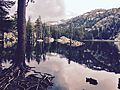
Woods Lake, situated in Alpine County
-
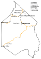
Locator map of communities in Alpine County


See also
 In Spanish: Condado de Alpine para niños
