
Amador County, California facts for kids
Quick facts for kids
Amador County, California
|
|||
|---|---|---|---|

The Amador County foothills in April 2007
|
|||
|
|||
| Nickname(s):
"The Heart of the Mother Lode"
|
|||

Location in the state of California
|
|||
| Country | |||
| State | |||
| Region | Sierra Nevada | ||
| Incorporated | May 1, 1854 | ||
| Named for | José María Amador | ||
| County seat | Jackson | ||
| Largest city | Ione (population and area) | ||
| Area | |||
| • Total | 606 sq mi (1,570 km2) | ||
| • Land | 595 sq mi (1,540 km2) | ||
| • Water | 11.4 sq mi (30 km2) | ||
| Highest elevation | 9,414 ft (2,869 m) | ||
| Population
(2020)
|
|||
| • Total | 40,474 | ||
| • Density | 66.79/sq mi (25.787/km2) | ||
| Time zone | UTC-8 (Pacific Time Zone) | ||
| • Summer (DST) | UTC-7 (Pacific Daylight Time) | ||
| Area code | 209 | ||
| FIPS code | 06-005 | ||
| GNIS feature ID | 1675841 | ||


Amador County is a county in the U.S. state of California, in the Sierra Nevada. As of the 2020 census, the population was 40,474. The county seat is Jackson. Amador County, located within California's Gold Country, is known as "The Heart of the Mother Lode". There is a substantial viticultural industry in the county.
Contents
History


_(17161938811).jpg)
Amador County was created by the California Legislature on May 11, 1854. The county later split into Amador, Calaveras, and El Dorado Counties. It was organized on July 3, 1854. In 1864, part of the county's territory was given to Alpine County.
The county is named for José María Amador, a soldier, rancher, and miner, born in San Francisco in 1794, the son of Sergeant Pedro Amador (a Spanish soldier who settled in California in 1771) and younger brother to Sinforosa Amador.
In 1848, Jose Maria Amador, with several Native Americans, established a successful gold mining camp near the present town of Amador City. In Spanish, the word amador means "one who loves". Some of the Mother Lode's most successful gold mines were located in Amador County, including the Kennedy, Argonaut, and Keystone.
In popular culture
"The Luck of Roaring Camp" is a short story by American author Bret Harte. It was first published in the August 1868 issue of the Overland Monthly and helped push Harte to international prominence. Harte lived in this area during his "Gold Rush" period, and possibly based the story in a mining camp on the Mokelumne River.
Geography
According to the U.S. Census Bureau, the county has a total area of 606 square miles (1,570 km2), of which 595 square miles (1,540 km2) is land and 11.4 square miles (30 km2) (1.9%) is water. It is the fifth-smallest county in California by land area and second-smallest by total area. Water bodies in the county include Lake Amador, Lake Camanche, Pardee Reservoir, Bear River Reservoir, Silver Lake, Sutter Creek, Cosumnes River, Mokelumne River, and Tabeaud Lake.
Amador County is located approximately 45 miles (72 km) southeast of Sacramento in the part of California known as the Mother Lode, or Gold Country in the Sierra Nevada.
Amador County ranges in elevation from approximately 250 feet (76 m) in the western portion of the county to over 9,000 feet (2,700 m) in the eastern portion of the county. The county is bordered on the north by the Cosumnes River and El Dorado County and on the south by the Mokelumne River and Calaveras County, on the west by Sacramento and San Joaquin Counties, and the east by Alpine County.
Shenandoah Valley


Though not as well known as the Napa Valley AVA or Sonoma Valley AVA viticultural regions of California, the Shenandoah Valley was once the principal viticultural region of California. With the discovery of gold, the area quickly became a mecca for those trying to make their fortune. In the process numerous wineries sprouted up, many of whose vineyards are still in use by wineries today. The decline of the California Gold Rush coupled with the onset of Prohibition devastated the wine-making region of Amador County. Today this area has been resurrected and is now home to over 40 different wineries. Amador County is renowned for its Zinfandel, but many other varietals are produced as well. Amador County has a high percentage of old Zinfandel vines. Some of the Zinfandel vineyards in this county are more than 125 years old, including the original Grandpère vineyard, planted with Zinfandel before 1869 and believed to be the oldest Zinfandel vineyard in America. This 10-acre (40,000 m2) vineyard is home to some of the oldest Zinfandel vines on Earth, with proof of their existence dating to 1869 when it was listed as a descriptor on a deed from the U.S. Geological Survey. A grant deed in Amador County records further proves their existence in 1869. These old vines produce intense flavors allowing winemakers to make outstanding Zinfandels.
National protected area
- Eldorado National Forest (part)
- Mokelumne Wilderness (part)
Gold mining
There are numerous gold mines in Amador County including the Argonaut Mine, the Kennedy Mine, the Central Eureka, and the Lincoln. The Kennedy Mine in Jackson was the deepest gold mine of its time. The federal government closed all of the Mother Lode's mines in 1942 because they were considered non-essential to the war effort. Recently the Sutter Gold Mining Company has attempted to re-open the Lincoln Mine just north of Sutter Creek. If the mine successfully reaches the operation phase, it will be the first corporately funded, large scale underground gold mine in the area in over 70 years.
Demographics
| Historical population | |||
|---|---|---|---|
| Census | Pop. | %± | |
| 1860 | 10,930 | — | |
| 1870 | 9,582 | −12.3% | |
| 1880 | 11,384 | 18.8% | |
| 1890 | 10,320 | −9.3% | |
| 1900 | 11,116 | 7.7% | |
| 1910 | 9,086 | −18.3% | |
| 1920 | 7,793 | −14.2% | |
| 1930 | 8,494 | 9.0% | |
| 1940 | 8,973 | 5.6% | |
| 1950 | 9,151 | 2.0% | |
| 1960 | 9,990 | 9.2% | |
| 1970 | 11,821 | 18.3% | |
| 1980 | 19,314 | 63.4% | |
| 1990 | 30,039 | 55.5% | |
| 2000 | 35,100 | 16.8% | |
| 2010 | 38,091 | 8.5% | |
| 2020 | 40,474 | 6.3% | |
| U.S. Decennial Census 1790–1960 1900–1990 1990–2000 2010 2020 |
|||
2020 census
| Race / Ethnicity | Pop 2010 | Pop 2020 | % 2010 | % 2020 |
|---|---|---|---|---|
| White alone (NH) | 30,325 | 29,725 | 79.61% | 73.44% |
| Black or African American alone (NH) | 938 | 1,215 | 2.46% | 3.00% |
| Native American or Alaska Native alone (NH) | 547 | 577 | 1.44% | 1.43% |
| Asian alone (NH) | 396 | 554 | 1.04% | 1.37% |
| Pacific Islander alone (NH) | 63 | 73 | 0.17% | 0.18% |
| Some Other Race alone (NH) | 130 | 249 | 0.34% | 0.62% |
| Mixed Race/Multi-Racial (NH) | 936 | 2,067 | 2.46% | 5.11% |
| Hispanic or Latino (any race) | 4,756 | 6,014 | 12.49% | 14.86% |
| Total | 38,091 | 40,474 | 100.00% | 100.00% |
Note: the US Census treats Hispanic/Latino as an ethnic category. This table excludes Latinos from the racial categories and assigns them to a separate category. Hispanics/Latinos can be of any race.
2011
| Population, race, and income | |||||
|---|---|---|---|---|---|
| Total population | 38,244 | ||||
| White | 33,454 | 87.5% | |||
| Black or African American | 870 | 2.3% | |||
| American Indian or Alaska Native | 889 | 2.3% | |||
| Asian | 529 | 1.4% | |||
| Native Hawaiian or other Pacific Islander | 82 | 0.2% | |||
| Some other race | 1,432 | 3.7% | |||
| Two or more races | 988 | 2.6% | |||
| Hispanic or Latino (of any race) | 4,677 | 12.2% | |||
| Per capita income | $28,030 | ||||
| Median household income | $56,180 | ||||
| Median family income | $69,521 | ||||
Places by population, race, and income
| Place | Type | Population | White | Other |
Asian | Black or African American |
Native American |
Hispanic or Latino (of any race) |
|---|---|---|---|---|---|---|---|---|
| Amador City | City | 158 | 100.0% | 0.0% | 0.0% | 0.0% | 0.0% | 0.0% |
| Buckhorn | CDP | 2,090 | 98.4% | 1.6% | 0.0% | 0.0% | 0.0% | 5.6% |
| Buena Vista | CDP | 435 | 68.5% | 25.1% | 0.0% | 0.0% | 6.4% | 0.0% |
| Camanche North Shore | CDP | 791 | 96.7% | 3.3% | 0.0% | 0.0% | 0.0% | 16.9% |
| Camanche Village | CDP | 704 | 100.0% | 0.0% | 0.0% | 0.0% | 0.0% | 0.0% |
| Drytown | CDP | 138 | 100.0% | 0.0% | 0.0% | 0.0% | 0.0% | 0.0% |
| Fiddletown | CDP | 121 | 100.0% | 0.0% | 0.0% | 0.0% | 0.0% | 0.0% |
| Ione | City | 7,873 | 70.7% | 14.6% | 2.6% | 9.7% | 2.4% | 25.3% |
| Jackson† | City | 4,626 | 90.7% | 4.8% | 1.2% | 0.8% | 2.5% | 16.6% |
| Kirkwood‡ | CDP | 158 | 96.8% | 0.0% | 0.6% | 2.5% | 0.0% | 0.0% |
| Martell | CDP | 140 | 100.0% | 0.0% | 0.0% | 0.0% | 0.0% | 0.0% |
| Pine Grove | CDP | 2,573 | 93.0% | 5.9% | 1.1% | 0.0% | 0.0% | 7.3% |
| Pioneer | CDP | 1,226 | 82.1% | 2.6% | 0.0% | 0.0% | 15.3% | 0.0% |
| Plymouth | City | 1,055 | 94.0% | 3.2% | 0.6% | 0.0% | 2.2% | 11.7% |
| Red Corral | CDP | 1,757 | 84.4% | 11.8% | 2.3% | 0.2% | 1.4% | 2.9% |
| River Pines | CDP | 578 | 97.1% | 0.0% | 2.9% | 0.0% | 0.0% | 6.9% |
| Sutter Creek | City | 2,497 | 93.4% | 1.5% | 4.8% | 0.0% | 0.3% | 5.3% |
| Volcano | CDP | 184 | 99.4% | 0.0% | 0.6% | 0.0% | 0.0% | 0.0% |
† County seat
‡ Data for Amador County area of this CDP
| Place | Type | Population | Per capita income | Median household income | Median family income |
|---|---|---|---|---|---|
| Amador City | City | 158 | $36,439 | $63,036 | $81,500 |
| Buckhorn | CDP | 2,090 | $31,611 | $50,365 | $54,833 |
| Buena Vista | CDP | 435 | $12,573 | $32,944 | $33,444 |
| Camanche North Shore | CDP | 791 | $31,857 | $58,309 | $79,125 |
| Camanche Village | CDP | 704 | $35,199 | $98,333 | $98,631 |
| Drytown | CDP | 138 | $20,676 | $21,172 | $70,595 |
| Fiddletown | CDP | 121 | $69,702 | $65,192 | $49,766 |
| Ione | City | 7,873 | $14,946 | $72,734 | $79,775 |
| Jackson† | City | 4,626 | $24,945 | $48,631 | $63,028 |
| Kirkwood‡ | CDP | 39 | $14,623 | $7,188 | |
| Martell | CDP | 140 | $23,051 | $50,962 | $90,391 |
| Pine Grove | CDP | 2,573 | $29,918 | $52,917 | $74,048 |
| Pioneer | CDP | 1,226 | $32,153 | $42,917 | $92,600 |
| Plymouth | City | 1,055 | $21,626 | $38,333 | $56,667 |
| Red Corral | CDP | 1,757 | $20,145 | $58,450 | $57,803 |
| River Pines | CDP | 578 | $30,626 | $31,544 | $38,875 |
| Sutter Creek | City | 2,497 | $26,788 | $46,316 | $51,389 |
| Volcano | CDP | 183 | $47,178 | $89,688 |
† County seat
‡ Data for Amador County area of this CDP
2010
The 2010 United States Census reported that Amador County had a population of 38,091. The racial makeup of Amador County was 33,149 (87.0%) White, 962 (2.5%) African American, 678 (1.8%) Native American, 419 (1.1%) Asian, 77 (0.2%) Pacific Islander, 1,450 (3.8%) from other races, and 1,356 (3.6%) from two or more races. Hispanic or Latino of any race were 4,756 persons (12.5%).
| Place | Type | Total population |
White | African American |
Native American |
Asian | Pacific Islander |
Other races |
Two or more races |
Hispanic or Latino (of any race) |
|---|---|---|---|---|---|---|---|---|---|---|
| Amador County | County | 38,091 | 33,149 | 962 | 678 | 419 | 77 | 1,450 | 1,356 | 4,756 |
| Amador City | City | 185 | 171 | 0 | 4 | 2 | 0 | 2 | 6 | 11 |
| Ione | City | 7,918 | 5,826 | 824 | 173 | 110 | 21 | 678 | 286 | 1,991 |
| Jackson† | City | 4,651 | 4,090 | 32 | 94 | 60 | 4 | 185 | 186 | 520 |
| Plymouth | City | 1,005 | 850 | 3 | 18 | 6 | 2 | 70 | 56 | 183 |
| Sutter Creek | City | 2,501 | 2,272 | 10 | 34 | 65 | 5 | 40 | 75 | 219 |
| Buckhorn | CDP | 2,429 | 2,259 | 9 | 37 | 25 | 4 | 47 | 48 | 168 |
| Buena Vista | CDP | 429 | 365 | 1 | 23 | 0 | 0 | 12 | 28 | 35 |
| Camanche North Shore | CDP | 979 | 860 | 3 | 14 | 12 | 3 | 38 | 49 | 150 |
| Camanche Village | CDP | 847 | 762 | 0 | 9 | 8 | 4 | 31 | 33 | 121 |
| Drytown | CDP | 167 | 153 | 0 | 0 | 1 | 0 | 2 | 11 | 11 |
| Fiddletown | CDP | 235 | 215 | 0 | 5 | 1 | 0 | 8 | 6 | 22 |
| Kirkwood‡ | CDP | 61 | 59 | 0 | 1 | 1 | 0 | 0 | 0 | 2 |
| Martell | CDP | 282 | 234 | 0 | 14 | 0 | 5 | 14 | 15 | 36 |
| Pine Grove | CDP | 2,219 | 2,027 | 9 | 36 | 9 | 6 | 49 | 83 | 202 |
| Pioneer | CDP | 1,094 | 1,017 | 0 | 34 | 1 | 2 | 12 | 28 | 52 |
| Red Corral | CDP | 1,413 | 1,259 | 24 | 15 | 12 | 3 | 33 | 67 | 147 |
| River Pines | CDP | 379 | 324 | 0 | 5 | 4 | 0 | 8 | 38 | 31 |
| Volcano | CDP | 115 | 109 | 0 | 2 | 2 | 0 | 0 | 2 | 7 |
| All others not CDPs (combined) | Others not CDPs | 11,182 | 10,297 | 47 | 160 | 100 | 18 | 221 | 339 | 848 |
† County seat
‡ Data for Amador County area of this CDP
Transportation
Major highways
 State Route 16
 State Route 26
 State Route 49
 State Route 88
 State Route 104
 State Route 124
Public transportation
Amador Transit provides service in Jackson and nearby communities. Connections to Calaveras County and Sacramento are additionally provided.
Airport
Amador County Airport is a general aviation airport located near Jackson.
Attractions
Amador County is home of the California Gold Rush, and many century-old gold-mining sites in the county are now popular tourist destinations, as are other attractions such as:
- Campgrounds areas with gold-panning activities
- Historic sites: Chew Kee Store in Fiddletown, Kennedy Mine in Jackson, Knight Foundry in Sutter Creek, Roaring Camp Mining Company
- Jackson Main Street – antique shops
- Jackson Rancheria – casino and hotel built in 1986 by Larry Graham Construction
- Lakes for boating and fishing
- Mace Meadows Golf Course in Pioneer
- Mokelumne River – fishing, gold panning, whitewater kayaking, swimming, picnics, water play
- Old Mill Shopping Center in Martell
- Outdoor Activities – camping, fishing, picnicking, ATV riding, backpacking, hiking, lake kayaking, horseback riding, whitewater kayaking, birding, snowshoeing, cross-country skiing, rock climbing, etc.
- Sutter Creek Main Street – antique shops, [1] Sutter Creek Theater
- Underground caves with tours (Black Chasm in Volcano)
- Volcano Theater Company and the Cobblestone Theater and the St. George Hotel in Volcano
- Wineries with wine-tasting activities
- Winter Ski Resorts – for skiers, snowboarders, etc.
Communities
Cities
- Amador City
- Ione
- Jackson (county seat)
- Plymouth
- Sutter Creek
Census-designated places
Unincorporated communities
- Allen
- Barton
- Bonnefoy
- Bunker Hill
- Carbondale
- Clarsona
- Clinton
- Dagon
- Edwin
- Electra
- Enterprise
- Firebrick
- Kit Carson
- New Chicago
- Pine Acres
- Plasse
- River Pines
- Roaring Camp
- Scottsville
- Sunnybrook
- Sutter Hill
Population ranking
The population ranking of the following table is based on the 2010 census of Amador County.
† county seat
| Rank | City/Town/etc. | Municipal type | Population (2010 Census) |
|---|---|---|---|
| 1 | Ione | City | 7,918 |
| 2 | † Jackson | City | 4,651 |
| 3 | Sutter Creek | City | 2,501 |
| 4 | Buckhorn | CDP | 2,429 |
| 5 | Pine Grove | CDP | 2,219 |
| 6 | Red Corral | CDP | 1,413 |
| 7 | Pioneer | CDP | 1,094 |
| 8 | Plymouth | City | 1,005 |
| 9 | Camanche North Shore | CDP | 979 |
| 10 | Camanche Village | CDP | 847 |
| 11 | Buena Vista | CDP | 429 |
| 12 | River Pines | CDP | 379 |
| 13 | Martell | CDP | 282 |
| 14 | Fiddletown | CDP | 235 |
| 15 | Amador City | City | 185 |
| 16 | Drytown | CDP | 167 |
| 17 | Kirkwood (partially in Alpine County) | CDP | 158 |
| 18 | Volcano | CDP | 115 |
| 19 | Ione Band of MiwokTDSA | AIAN | 5 |
Economy
The Shenandoah Valley was once the principal viticultural region of California though not as well known as the Napa Valley AVA or Sonoma Valley AVA viticultural regions. With the discovery of gold, the area quickly became a mecca for those trying to make their fortune. In the process numerous wineries sprouted up, many of whose vineyards are still in use by wineries today. The decline of the California Gold Rush coupled with the onset of Prohibition devastated the wine-making region of Amador County. Today this area has been resurrected and is now home to over 40 different wineries. Amador County is known for its Zinfandel, but many other varietals are produced as well. Amador County has a high percentage of old Zinfandel vines. Some of the Zinfandel vineyards in this county are more than 125 years old, including the original Grandpère vineyard, planted with Zinfandel before 1869 and believed to be the oldest Zinfandel vineyard in America. This 10-acre (40,000 m2) vineyard is home to some of the oldest Zinfandel vines on earth, with proof of their existence dating to 1869 when it was listed as a descriptor on a deed from the U.S. Geological Survey. A grant deed in Amador County records further proves their existence in 1869.
Education
Due to the low population of the area, there are few schools with small class sizes. In total for public schools, there are two high schools, two junior high schools, and six elementary schools. These numbers are in addition to two independent study schools, one charter school, and one continuing education school for adults. There are no colleges or universities within the county's borders.
Images for kids
-
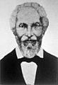
Amador County is named after José María Amador, a Californio miner who found gold in the area in 1848.
.jpg)
See also
 In Spanish: Condado de Amador para niños
