
Fullerton, California facts for kids
Quick facts for kids
Fullerton, California
|
|||
|---|---|---|---|
| City of Fullerton | |||
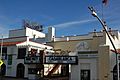
.jpg) .jpg) .jpg) .jpg) Clockwise from top left: Old City Hall, the Chapman Building, Fullerton Transportation Center, downtown.
|
|||
|
|||
| Motto(s):
"The Education Community"
|
|||

Location of Fullerton in Orange County, California.
|
|||

Fullerton, California
Location in the United States
|
|||
| Country | United States | ||
| State | California | ||
| County | Orange | ||
| Incorporated | February 15, 1904 | ||
| Government | |||
| • Type | Council-Manager | ||
| Area | |||
| • Total | 22.44 sq mi (58.11 km2) | ||
| • Land | 22.42 sq mi (58.07 km2) | ||
| • Water | 0.01 sq mi (0.03 km2) 0.05% | ||
| Elevation | 164 ft (50 m) | ||
| Population
(2020)
|
|||
| • Total | 143,617 | ||
| • Rank | 6th in Orange County 41st in California 188th in the United States |
||
| • Density | 6,411/sq mi (2,475/km2) | ||
| Demonym(s) | Fullertonian | ||
| Time zone | UTC−8 (PST) | ||
| • Summer (DST) | UTC−7 (PDT) | ||
| ZIP Codes |
92831–92838
|
||
| Area codes | 562, 657/714 | ||
| FIPS code | 06-28000 | ||
| GNIS feature IDs | 1660658, 2410556 | ||


Fullerton ( fuul-ƏR-tən) is a city located in northern Orange County, California, United States. As of the 2020 census, the city had a total population of 143,617.
Fullerton was founded in 1887. It secured the land on behalf of the Atchison, Topeka and Santa Fe Railway. Historically it was a center of agriculture, notably groves of Valencia oranges and other citrus crops; petroleum extraction; transportation; and manufacturing. It is home to numerous higher educational institutions, particularly California State University, Fullerton and Fullerton College. From the mid-1940s through the late 1990s, Fullerton was home to a large industrial base made up of aerospace contractors, canneries, paper products manufacturers, and is considered to be the birthplace of the electric guitar, due in large part to Leo Fender. The headquarters of Vons, which is owned by Albertsons, is located in Fullerton near the Fullerton–Anaheim line.
Contents
History
Early history
Evidence of prehistoric animal habitation, such as saber-toothed cats and mammoths, is present in Ralph B. Clark Regional Park in the northwest of the city. Europeans first passed through the area in 1769 when Gaspar de Portolà led a Spanish expedition north to Monterey. From the description recorded in the diary of Father Juan Crespi, it seems likely that the party camped on July 29 near present-day Laguna Lake, in the Sunny Hills area.
After establishment of Mission San Gabriel Arcangel in 1771, the local Tongva people were dubbed "Gabrieliños" by the Spanish. In 1837, the Fullerton area became part of Rancho San Juan Cajón de Santa Ana, granted to Juan Pacifico Ontiveros, a Spanish soldier.
Ontiveros began to sell parcels of the Rancho to migrant Americans settling and developing California in the aftermath of the 1849 Gold Rush, including Massachusetts native Abel Stearns. In the 1860s, Stearns sold in turn to Domingo Bastanchury, a Basque shepherd.
In 1886 while in the area on a duck hunting vacation, Malden brothers George and Edward Amerige, heard rumors that the California Central Railroad, a subsidiary of the Santa Fe Railway, was looking for land. Sensing opportunity, they arranged to buy 430 acres (1.7 km2) north of Anaheim for approximately $68,000.
They then began negotiations with George H. Fullerton, president of the Pacific Land and Improvement Company, also a Santa Fe subsidiary. They offered free right-of-way and half interest in the land to the railroad if Fullerton's survey were revised to include the proposed town site, and on July 5, 1887 Edward Amerige formally staked his claim at what is now the intersection of Harbor Boulevard and Commonwealth Avenue.
In 1894 Charles Chapman, a retired Chicago publisher and a descendant of John "Johnny Appleseed" Chapman, purchased an orange orchard in eastern Fullerton. The Valencia variety of oranges he promoted from his Santa Ysabel Ranch, well suited to the local climate, proved a boon to producers; Fullerton boasted more orange groves than any other municipality in the United States. Cultivation of walnuts and avocados also flourished, and the Western railroad town became an agricultural center. Fullerton incorporated in 1904.
Boom years

Drilling for petroleum began in 1880 with the discovery of the Brea-Olinda Oil Field and fueled the first real boom, peaking in the 1920s. Construction reflected the vogue for Spanish Colonial and Italian Renaissance-inspired architecture, as in the historic Fox Fullerton Theatre (erected 1925); the home of Walter and Adella Muckenthaler, designed by Frank K. Benchley (erected 1924); and the city's chief landmark, the Plummer Auditorium and clock tower (erected 1930). Fullerton College was established at its present location at Chapman Avenue and Lemon Street in 1913. Meanwhile, the city banned all overnight street parking in 1924— a law enforced to the present day. The period from 1910-1950 represented a golden age for the city which like other Southern California cities were marked with elegant architecture ranging from the Beaux Arts Movement to the distinctive California Mediterraneum architecture, which in turn were surrounded by bucolic farms and parks. Significant public works projects were constructed during this period, including the conversion of a southwestern sewer farm into Fullerton Municipal Airport at the behest of Placentia ranchers and aviators William and Robert Dowling in 1927.Following the depression, concentration of industry, a depressed farming economy, and cheap land development shattered the earlier period quality of life. Through the mid-1900s the economy shifted toward food processing rather than food production, as well as manufacturing; southeastern Fullerton became an industrial center. Val Vita Food Products (later Hunt Wesson and today part of ConAgra Foods, Inc.) began operating a citrus juice plant in western Fullerton in 1932. By 1941 it had become the largest food processing company in the US. In 1934 A.W. Leo, Tom Yates and Ralph Harrison developed the first Hawaiian Punch recipe in a converted garage in Fullerton. The city also became a producer of aerospace equipment, electrical and electronic components, navigation systems, and laboratory instruments.
In 1949 Dick Riedel and Bill Barris piloted the Sunkist Lady, a modified Aeronca Sedan, out of the Fullerton airport to set an endurance flight record of 1,008 hours and 2 minutes.
Also in 1949, Fullerton was the setting in which Leo Fender developed and refined the design of the Fender Telecaster, a guitar which would later be used among some of the greatest musicians of the 20th and 21st Century. Among them: Bruce Springsteen, Keith Richards, Joe Strummer, Waylon Jennings, Dwight Yoakam, Greg Camp, Jimmy Page, Kurt Cobain, James Burton, Jonny Greenwood and many others.
Postwar suburbanization
Although Fullerton like other Southern California cities had experienced an expansion of population due to housing development, this increased by an order of magnitude during the post war years. Fullerton's population soared after World War II as American veterans migrated to California, bought housing in the land development which destroyed the surrounding farming and park areas, and in particular after the construction of Interstate 5 and development in neighboring Anaheim.
To serve the growing population, the California State Legislature authorized Orange County State College in 1957, which began operating out of Fullerton high schools in 1959. In 1963, it moved to its present campus on State College Boulevard, and later, after several name-changes, was finally redesignated California State University, Fullerton. Other institutions followed, earning Fullerton a reputation as an "Education City." The Fullerton Arboretum, a 26-acre (105,000 m²) botanical garden, opened in the northeastern part of the city adjacent the campus in 1979.
Manufacturing growth leveled off as ever-soaring property prices, increasing environmental regulation, traffic, and other pressures increased. By the late 20th century the city had lost much of its rural character in favor of suburban housing tracts and shopping centers.
Recent history

The first years of the 21st century have seen several political issues played out against a backdrop of class division (between the more affluent northern and western parts of the city and the southern portion of the city, which borders Anaheim), rapidly diminishing supplies of undeveloped land, and demographic changes (including the influx of Asian and Latino immigrants into an area previously dominated by Caucasian Americans).
As in many cities, growth and development are contentious issues. In the 1990s, the downtown commercial district had become economically depressed, and was known mainly for being an area of sleepy antique stores and small shops. A symbol of downtown's problems was the Fox Theatre, a local landmark, which had fallen into disrepair. As of November 2004, a fundraising drive had accumulated sufficient funds to buy the theater, but not yet enough money to restore it. By 2006, restoration was started.
During this same period, the downtown area (a.k.a. DTF), especially south of Commonwealth Avenue (a.k.a. SOCO), has become more of a busy entertainment district, described by the OC Weekly as "Bourbon Street West." In less than five years, some 30 businesses that sell alcohol have opened, making the downtown area much more active at night. Ranging from a mixture of Mexican cantinas and Asian bars to Jazz, local venues and music stores, with the festive atmosphere have come problems such as public drunkenness, fights and a shortage of parking. In 2008, City Manager Chris Meyer called together department head and the finance department and reported to the city council that the Restaurant Overlay District (established December 2002)was costing the city $935,000 over and above the sales taxes collected. Then four officers were hired for downtown, bringing the costs to $1,600,000 a year. The ROD had abolished condition use; a new ordinance to establish restrictions was drafted and adopted by the city council in 2008. a police task force last year has addressed some of these problems.
The 293-acre (1.19 km2) Hughes Aircraft Company's Ground Systems Group campus in western Fullerton was redeveloped into a major new residential and commercial district, called Amerige Heights, in 2001–2004. This development was accompanied by extreme shifts in neighborhood property values, first dropping precipitously in the late 1980s to early 1990s as the former Hughes employees sold their houses, and then rising rapidly as part of a general increase in real estate values throughout Orange County.
Geography

Fullerton is located at 33°52′48″N 117°55′43″W / 33.88000°N 117.92861°W (33.879914, -117.928749). It is approximately 25 miles (40 km) southeast of downtown Los Angeles, and approximately 11 miles (18 km) north-northwest of Santa Ana, the county seat. The city has a mean elevation of 150 feet (46 m) and lies approximately 11 miles (18 km) northeast of the Pacific Ocean straight-line distance. It has a Mediterranean climate, with a mean temperature of 62.2 degrees Fahrenheit (16.8 °C).
According to the United States Census Bureau, the city has a total area of 22.4 square miles (58 km2). 22.4 square miles (58 km2) of it is land and 0.01 square miles (0.026 km2) of it (0.05%) is water.
It is bordered by La Habra and Brea on the north, La Mirada on the northwest, Buena Park on the west, Anaheim on the south, and Placentia on the east.
The flat downtown area is laid out in a grid plan centered at the intersection of Harbor Boulevard and Commonwealth Avenue. After recent renewal and beautification projects, it has attracted specialty stores, coffee shops, and restaurants, and has uncharacteristically retained much of its downtown character. Southeastern Fullerton is historically the industrial sector, and is home to small manufacturing, particularly east of Raymond Street and south of Commonwealth.
The northern and western reaches of Fullerton are dominated by the Coyote Hills, a low-lying mountain range divided into the East Coyote Hills and West Coyote Hills; the lands nestled to their south and west are known as Sunny Hills. For most of the city's history these areas were groves of citrus trees, open scrubland, and oil fields. While equestrian trails and many old estates endure along Bastanchury Road, the meandering roads through these areas today mostly connect a succession of housing tract subdivisions and commercial developments. In recent years, the City Council has tried to allow development in the remaining open land throughout the city. The most notable impending project, in West Coyote Hills, has been met with opposition by many of the citizens in the area.
Climate
According to the Köppen Climate Classification system, Fullerton has a warm-summer Mediterranean climate, abbreviated "Csa" on climate maps.
| Climate data for Fullerton Municipal Airport (1981–2010 normals) | |||||||||||||
|---|---|---|---|---|---|---|---|---|---|---|---|---|---|
| Month | Jan | Feb | Mar | Apr | May | Jun | Jul | Aug | Sep | Oct | Nov | Dec | Year |
| Record high °F (°C) | 95 (35) |
94 (34) |
97 (36) |
106 (41) |
106 (41) |
104 (40) |
107 (42) |
102 (39) |
108 (42) |
107 (42) |
99 (37) |
89 (32) |
108 (42) |
| Average high °F (°C) | 67.8 (19.9) |
68.1 (20.1) |
69.8 (21.0) |
72.8 (22.7) |
75.0 (23.9) |
78.4 (25.8) |
83.2 (28.4) |
85.4 (29.7) |
83.8 (28.8) |
78.5 (25.8) |
72.3 (22.4) |
67.4 (19.7) |
75.2 (24.0) |
| Average low °F (°C) | 44.6 (7.0) |
47.6 (8.7) |
50.1 (10.1) |
52.4 (11.3) |
57.7 (14.3) |
61.1 (16.2) |
64.5 (18.1) |
65.3 (18.5) |
63.2 (17.3) |
57.3 (14.1) |
49.7 (9.8) |
44.8 (7.1) |
54.9 (12.7) |
| Record low °F (°C) | 30 (−1) |
30 (−1) |
37 (3) |
38 (3) |
45 (7) |
50 (10) |
54 (12) |
53 (12) |
51 (11) |
45 (7) |
33 (1) |
32 (0) |
30 (−1) |
| Average precipitation inches (mm) | 3.03 (77) |
3.25 (83) |
2.16 (55) |
0.87 (22) |
0.25 (6.4) |
0.09 (2.3) |
0.04 (1.0) |
0.05 (1.3) |
0.24 (6.1) |
0.75 (19) |
1.10 (28) |
2.05 (52) |
13.88 (353.1) |
| Source: Monthly Climate Normals (1981-2010)- Fullerton Muni AP,CA | |||||||||||||
Culture and recreation
Fullerton is home to a vibrant music scene. It was a center for the Orange County hardcore punk music scene, producing acts such as The Adolescents, Agent Orange, Social Distortion, D.I., the "fathers of hardcore punk" The Middle Class, Gwen Stefani, lead vocalist of the alternative rock group No Doubt, was a student at CSUF and the group performed there regularly. Other popular groups and musicians from the area include Lit, 80s synthpop acts Berlin and Stacey Q, and Mike Ness. The popular singer-songwriter Jackson Browne attended Sunny Hills High School in the city. Singer-songwriter Tim Buckley also attended Fullerton College and dropped out after only a few weeks to focus on his music career.
Contributing greatly to Fullerton's musical heritage was the Fender musical instrument company, whose products such as the Stratocaster and Telecaster electric guitars, Precision Bass bass guitar, and Twin Reverb guitar amplifier revolutionized the music business and contributed greatly to the development of rock and roll. Leo Fender sold the company to CBS in 1964; production continued in the Fullerton plant until 1985, when the then-ruined company was sold to a group of private investors. (It was later reconstituted as Fender Musical Instrument Corporation, with its major production facilities in neighboring Corona and across the US-Mexico border in Ensenada, Baja California, and its headquarters in Scottsdale, Arizona.) In 1980, Leo Fender and his original partner George Fullerton (relation to the Fullerton founder of the same name unknown) reunited and started a new company, G&L (George and Leo) Guitars, which are built in what had been Leo Fender's CLF Research factory in Fullerton.
The Muckenthaler Cultural Center on Malvern Avenue near Euclid Avenue houses art galleries and a theater group. The former estate of the Muckenthaler family, it was donated to the city by Harold Muckenthaler in 1965. Fullerton Friends of Music, the oldest chamber music society in Orange County, perform five concerts a year at Sunny Hills Performing Arts Center, a notable classical concert venue in the county.
The Fullerton Museum Center is a multidisciplinary exhibit space housed in the old Carnegie Library downtown.

Fullerton is also home to the Fullerton Public Library. The Main Library is located on Commonwealth Avenue in Downtown Fullerton and adjacent to the City Hall. There is also a branch library, called the Hunt Branch on Basque Avenue.
Fullerton is also home to a small but diverse theater scene. Local educational institutions, such as Fullerton College and Fullerton High School's Academy of the Arts, are the source of numerous large-scale productions. There are also several storefront theaters, including the Maverick Theater, Stages Theater and the Hunger Artists Theatre Company. The Maverick Theatre is the host for the "World Famous Skipper Stand Up Show." Held six times a year, The Skipper Stand Up Show has, since 2006, showcased former and current skippers from Disneyland's famous attraction, the Jungle Cruise.
In addition to the theater scene, Fullerton has garnered attention for rare and international film screenings hosted by filmmaker Steve Elkins at the Hibbleton Gallery in the SOCO district.
Fullerton maintains more than 50 city parks and is home to Hillcrest Park, the Craig Regional Park and Ralph B. Clark Regional Park. The Fullerton Arboretum comprises 26 acres (11 ha) (105,000 m²) of sculpted gardens and unusual plants in northeastern Fullerton. Additionally the city features approximately 200 acres (0.81 km2) of recreational land in the Brea Dam Recreational Area, plus an equestrian center and trails, two golf courses, a tennis center located behind St. Jude Hospital and the Janet Evans swim Complex.
The city is also one of the few Southern California municipalities to be served by a completely independent newspaper, the Fullerton Observer. The Observer is an all-volunteer paper that is printed two times a month. It was founded in the late 1970s by Ralph Kennedy, a fair housing and civil rights activist who advocated saving Coyote Hills as open space.In 2010, the city of Fullerton and the Orange County Register came out in court against the 32-year-old Fullerton Observer in its request to adjudicate the paper. In response to the city of Fullerton and the Orange County Register's request the Fullerton Observer prove itself a newspaper, the Fullerton Observer dropped its court case to be adjudicated a newspaper.
Fullerton is also home to the Golden Baseball League's Orange County Flyers (formerly known as the Fullerton Flyers). The team's home is Goodwin Field, home to the Cal State Fullerton Titans.
The city is also home to Burger Records.
Demographics
| Historical population | |||
|---|---|---|---|
| Census | Pop. | %± | |
| 1910 | 1,725 | — | |
| 1920 | 4,415 | 155.9% | |
| 1930 | 10,860 | 146.0% | |
| 1940 | 10,442 | −3.8% | |
| 1950 | 13,958 | 33.7% | |
| 1960 | 56,180 | 302.5% | |
| 1970 | 85,987 | 53.1% | |
| 1980 | 102,246 | 18.9% | |
| 1990 | 114,144 | 11.6% | |
| 2000 | 126,003 | 10.4% | |
| 2010 | 135,161 | 7.3% | |
| 2020 | 143,617 | 6.3% | |
| U.S. Decennial Census | |||
2000

In 2000, there were 44,771 housing units at an average density of 2,016.7 per square mile (778.7/km2). There were 43,609 households, out of which 33.0% had children under the age of 18 living with them, 51.8% were married couples living together, 11.0% had a female householder with no husband present, and 32.1% were non-families. 23.5% of all households were made up of individuals, and 7.3% had someone living alone who was 65 years of age or older. The average household size was 2.83 and the average family size was 3.37.
In the city, the population was spread out, with 25.1% under the age of 18, 11.5% from 18 to 24, 32.3% from 25 to 44, 19.8% from 45 to 64, and 11.3% who were 65 years of age or older. The median age was 33 years. For every 100 females, there were 97.7 males. For every 100 females age 18 and over, there were 96.1 males.
The median income for a household in the city was $57,345 (Orange County 2005), and the median income for a family was $75,700. Males had a median income of $40,674 versus $31,677 for females. The per capita income for the city was $23,370. About 8.0% of families and 11.4% of the population were below the poverty line, including 13.6% of those under age 18 and 5.4% of those age 65 or over.
2010


The 2010 United States Census reported that Fullerton had a population of 135,161. The population density was 6,043.9 people per square mile (2,333.6/km2). The racial makeup of Fullerton was 72,845 (53.9%) White, 3,138 (2.3%) African American, 842 (0.6%) Native American, 30,788 (22.8%) Asian, 321 (0.2%) Pacific Islander, 21,439 (15.9%) from other races, and 5,788 (4.3%) from two or more races. Hispanic or Latino of any race were 46,501 persons (34.4%). Non-Hispanic Whites were 38.2% of the population, down from 79.0% in 1980.
The Census reported that 132,084 people (97.7% of the population) lived in households, 2,318 (1.7%) lived in non-institutionalized group quarters, and 759 (0.6%) were institutionalized.
There were 45,391 households, out of which 16,155 (35.6%) had children under the age of 18 living in them, 23,240 (51.2%) were opposite-sex married couples living together, 5,502 (12.1%) had a female householder with no husband present, 2,505 (5.5%) had a male householder with no wife present. There were 2,366 (5.2%) unmarried opposite-sex partnerships, and 290 (0.6%) same-sex married couples or partnerships. 9,771 households (21.5%) were made up of individuals, and 3,342 (7.4%) had someone living alone who was 65 years of age or older. The average household size was 2.91. There were 31,247 families (68.8% of all households); the average family size was 3.43.
The population was spread out, with 31,558 people (23.3%) under the age of 18, 17,522 people (13.0%) aged 18 to 24, 37,764 people (27.9%) aged 25 to 44, 32,465 people (24.0%) aged 45 to 64, and 15,852 people (11.7%) who were 65 years of age or older. The median age was 34.8 years. For every 100 females, there were 96.6 males. For every 100 females age 18 and over, there were 94.4 males.
There were 47,869 housing units at an average density of 2,140.5 per square mile (826.5/km2), of which 24,600 (54.2%) were owner-occupied, and 20,791 (45.8%) were occupied by renters. The homeowner vacancy rate was 1.1%; the rental vacancy rate was 7.0%. 73,127 people (54.1% of the population) lived in owner-occupied housing units and 58,957 people (43.6%) lived in rental housing units.
According to the 2010 United States Census, Fullerton had a median household income of $67,617, with 14.6% of the population living below the federal poverty line.
Sister cities
 Yongin, South Korea
 Fukui, Japan
 Morelia, Mexico
Economy

According to the city's 2020 Comprehensive Annual Financial Report, the top employers in the city are:
| # | Employer | # of employees |
|---|---|---|
| 1 | California State University, Fullerton | 3,000 |
| 2 | St. Jude Medical Center | 1,797 |
| 3 | Raytheon | 1,200 |
| 4 | AJ Kirkwood & Associates, Inc. | 600 |
| 5 | Albertsons Regional Corporate | 400 |
| 6 | Morningside of Fullerton | 350 |
| 7 | Corovan | 300 |
| 8 | RPM Transportation | 300 |
| 9 | Adams Rite Aerospace | 250 |
| 10 | Nordstrom Design Center | 250 |
Education


Public schools
The city of Fullerton is served by three elementary and junior high school districts, two unified school districts, and one high school exclusive school district:
- La Habra City School District
- Buena Park School District
- Fullerton School District
- Brea Olinda Unified School District
- Placentia-Yorba Linda Unified School District
- Fullerton Joint Union High School District
Fullerton has four public high schools within the city limits, all part of the Fullerton Joint Union High School District:
- Sunny Hills High School.
- Fullerton Union High School. The oldest high school in Orange County, it is the home of historic Plummer Auditorium and the Academy of the Arts magnet program.
- Troy High School (which includes Troy Tech, a public magnet program).
- La Vista High School and La Sierra High School (continuation schools, adjacent to Troy)
Other public schooling in Fullerton is provided by the Fullerton School District. There are four public junior high schools, enrolling grades 7-8: Ladera Vista, Nicolas, Parks, and D. Russell Parks Junior High School. Fullerton has only two public elementary K-8 schools: Beechwood and Robert C. Fisler. Fullerton has fifteen public elementary schools enrolling grades K-6: Acacia, Commonwealth, Fern Drive, Golden Hill, Hermosa Drive, Laguna Road, Maple, Orangethorpe, Pacific Drive, Raymond, Richman, Rolling Hills, Sunset Lane, Valencia Park, and Woodcrest.
Private schools
Fullerton's Catholic schools are affiliated with the Roman Catholic Diocese of Orange. They include: Annunciation Catholic School, Saint Justin School, Saint Juliana School, and Rosary Academy.
Other private schools include the Arborland Montessori School, the IvyCrest Montessori School, Eastside Christian School, West Fullerton Christian School, and Berkeley School.
Postsecondary institutions
- California State University, Fullerton, commonly known as Cal State Fullerton or CSUF, was first established in 1957 as Orange County State College. The twelfth member of the California State University system, it is currently composed of eight colleges, a community extended education program and several institutions and centers. The main campus is located on 236 acres (0.96 km2) of former orange groves in northeast Fullerton near State Route 57 and Nutwood Avenue. As of 2019, 39,868 students were enrolled in 55 undergraduate and 55 graduate degree programs (including doctorate in education and doctor in nursing practice programs), making it the largest university in the California State University system and the second largest university in the state of California in terms of enrollment.
- Fullerton College is a two-year community college, the oldest in continuous operation in California. Part of the North Orange County Community College District, it is situated on a 63-acre (255,000 m2) campus adjacent to Fullerton Union High School on Chapman Avenue and had 25,051 students enrolled as of 2019. The college offers 90 majors leading to A.A. or A.S. degrees in academic and vocational subjects, 68 programs leading to vocational certificates, and transfer programs specializing in preparing students to transfer into the California State University and University of California systems.
- Hope International University is a private Christian university
- Marshall B. Ketchum University is a health sciences university.
Transportation
Rail


Fullerton was founded as a railroad town and is still bisected by the BNSF Railway.
The Fullerton Transportation Center is home to train station serving Metrolink and Amtrak and a major north Orange County bus terminal for the Orange County Transportation Authority. The center is located at Harbor Blvd and Santa Fe Avenue. The bus terminal is located north of Santa Fe Avenue and serves routes 26, 43, 143, 543, and 213. The Fullerton Train Station is located south of Santa Fe Avenue.
The Southern California Metrolink commuter rail system serves the city of Fullerton from the Orange County Line (Union Station, Los Angeles to Oceanside, California) and the 91/Perris Valley Line (Union Station, Los Angeles to Perris Valley in Riverside County). Travel time on Metrolink or Amtrak from Fullerton to Los Angeles is approximately 45 minutes. The city is served by two Amtrak lines. The Southwest Chief (running between Chicago and Los Angeles) and the Pacific Surfliner (running between San Diego and San Luis Obispo with major stops at Los Angeles and Santa Barbara).
In addition to the Fullerton Transportation Center, the Orange County Transportation Authority has a park and ride transportation hub in Fullerton located on Orangethorpe Avenue at Magnolia Avenue which makes connections to OCTA routes 25, 26, 30, 33, 35, 529, and 721 (Downtown Los Angeles) and Los Angeles Metro 460 (Downtown Los Angeles).
Roads

Fullerton is crossed by five state-maintained highways (all maintained by Caltrans' 12th district), three of which are freeways. State Route 91, the Riverside Freeway, runs east-to-west down the length of the city south of Orangethorpe Avenue. It intersects with Interstate 5, the Santa Ana Freeway, in the west near Magnolia Avenue and with State Route 57, the Orange Freeway, in the east near State College Boulevard. Short portions of State Route 39 (Beach Boulevard) and State Route 90 (Imperial Highway), also run through western and northern portions of the city, respectively.
The main road in Fullerton is Harbor Boulevard (served by OCTA route 43/143/543), a 23-mile road running from Costa Mesa to Rowland Heights. Fullerton is composed of many main arterials. Other main south-to-north arterials include Magnolia Street, Brookhurst Street, Lemon Street, Placentia Avenue, Gilbert Street, Raymond Avenue, State College Boulevard (served by OCTA route 57/57X), Brea Boulevard (served by OCTA route 143), Euclid Street (served by OCTA route 37). Rosecrans Avenue, Bastanchury Road (not served by OCTA), Chapman and Malvern Avenues (served by OCTA route 24), Commonwealth Avenue (served by OCTA route 26) and Orangethorpe Avenue (served by OCTA route 30) are the main west-to-east arterials. Yorba Linda Boulevard (served by OCTA route 26) runs along the east end of the city. Minor arterials include Nutwood Avenue, Associated Road, Highland Avenue, Berkeley Avenue, Parks Road/Castlewood Drive, Kimberly Avenue, Acacia Avenue, Valencia Drive, and Dale Street.
Airport
Fullerton Municipal Airport, the only general aviation airport remaining in Orange County, located in the southwest of the city, is the last remnant of the Hughes Company in the area, which was prominent in the aerospace industry up until the 1970s. From the early 1970s through the early 1980s the airport was served by Golden West Airlines, one of the larger commuter airlines of the period. The nearest airport with scheduled service is John Wayne Airport (SNA) in Santa Ana.
Images for kids
-
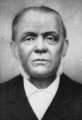
In 1837, Juan Pacífico Ontiveros, a Californio ranchero, was granted Rancho San Juan Cajón de Santa Ana, including all of modern-day Fullerton.
-
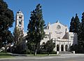
Fullerton Union High School's auditorium, built 1930-32.
-

The historic Union Pacific depot, built in 1923.
-
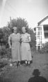
Val Vita Food Products workers, 1940.
-
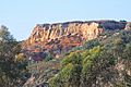
Cliffs in the West Coyote Hills.
-
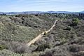
The West Coyote Hills are one of the last open spaces in northern Orange County
-
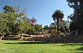
Hillcrest Park is on the National Register of Historic Places.
-
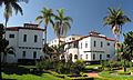
The Dewella complex is on the National Register of Historic Places.
-
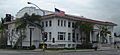
Fullerton Masonic Temple.
-
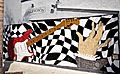
Downtown mural honoring the Fender Musical Instrument Company.
-
The Fox Theatre, built in 1925.


_(cropped).jpg)


.jpg)
.jpg)

.jpg)

See also
 In Spanish: Fullerton (California) para niños
