
Victorville, California facts for kids
Quick facts for kids
Victorville, California
|
|||
|---|---|---|---|
| City of Victorville | |||
 |
|||
|
|||

Location of Victorville in San Bernardino County, California
|
|||

Victorville, California
Location in California

Victorville, California
Location in the United States
|
|||
| Country | United States | ||
| State | California | ||
| County | San Bernardino | ||
| Incorporated | September 21, 1962 | ||
| Named for | Jacob Nash Victor | ||
| Area | |||
| • Total | 74.01 sq mi (191.69 km2) | ||
| • Land | 73.72 sq mi (190.94 km2) | ||
| • Water | 0.29 sq mi (0.74 km2) 0.76% | ||
| Elevation | 2,726 ft (831 m) | ||
| Population
(2020)
|
|||
| • Total | 134,810 | ||
| • Rank | 5th in San Bernardino County 45th in California |
||
| • Density | 1,821.51/sq mi (703.27/km2) | ||
| Time zone | UTC−8 (Pacific Time Zone) | ||
| • Summer (DST) | UTC−7 (PDT) | ||
| ZIP Codes |
92392–92395
|
||
| Area codes | 442/760 | ||
| FIPS code | 06-82590 | ||
| GNIS feature IDs | 1652806, 2412156 | ||
| Website | www.victorvilleca.gov | ||


Victorville is a city in Victor Valley in San Bernardino County, California. Its population as of the 2020 census was 134,810.
Contents
History
In 1858, Aaron G. Lane came to what is now known as Victorville and founded a way station called "Lane's Crossing." For many years it provided shelter and supplies for people making the journey across the desert from the east to San Bernardino. Lane's Crossing was on the Mojave River on today's Turner Road, two miles north from where Interstate 15 crosses the river. Captain Lane was a veteran of the Mexican-American War who had suffered from malaria during that war. Originally he migrated west to join the California gold rush, but he learned that he could make a better living selling supplies to the miners.
He settled in Ione near Sutter's Mill in northern California during those years, but he migrated to San Bernardino in 1857. He settled on the Mojave River in 1858, where he established his way station. He later sold out to Texan John Fry Miller, who changed the name of Lane's Crossing to Pioneer Station. Miller was a rancher and became involved in Mojave Valley politics, setting up the first polling place in the area at his home. That first year, ten citizens cast their votes at Lane's residence, rather than making the long trip to San Bernardino.
Census records show that ten people lived in two residences on the river by 1860. Listed in Dwelling No. 703 were Aaron Lane, William R. Levick, and the Nicholson family, consisting of George and Frances, and their three children aged 9 to 13. Joseph and Mary Highmoor lived in Dwelling No. 704, with a seven-year-old female named Anna.
The Levick, Nicholson and Highmoor families were Mormon pioneers. Highmoor established a way station called Highmoor's Crossing, which was near today's Oro Grande bridge of the National Trails Highway (known as U.S. Route 66), over the Mojave River at what is called the Lower Narrows. The Nicholson family moved downriver a few miles and established a way station at "Point of Rocks" in today's Helendale area.
In 1867, Lafayette Meacham, a Mormon who ran a way station near today's Barstow area, made a new wagon road from his stage stop to what is now Old Town Victorville. It crossed the Mojave River at today's Sixth Street. This new road, now called Stoddard Wells Road, was a short-cut across the desert and became a popular route for muleskinners and freighters. The river crossing was called Mormon Crossing and the surrounding area became known by that name.
In the 1870s, Heber "Pete" Huntington established a stage stop, Huntington Station, at Mormon Crossing. Also a Mormon pioneer, Huntington was leader Brigham Young's nephew. Huntington later bought out the Stoddard brothers, who had a way station half way to today's Barstow from Victorville, and also bought out the Meachams, who ran the stage stop named Fish Ponds or Mormon Grocery.
In 1885, the newly established telegraph station at the railroad siding of "Victor", named for the California Southern Railroad's General Manager Jacob Nash Victor, was the beginning of what developed as today's Old Town Victorville. The village which sprang up around that railroad facility became known by the same name of Victor.
In 1901, at the suggestion of local postmistress Abbey Turner, the U.S. Post Office Department changed that name to Victorville to stop the postal confusion with the town of Victor, Colorado.
In 1926, U.S. Route 66 was begun, being marked in many areas on existing roads. In Victorville, US 66 is marked on D and Seventh streets, with a section of Interstate 15 going towards the Cajon Pass. It is the primary street through Old Town Victorville.
In 1940, Herman J. Mankiewicz and John Houseman wrote the first two drafts of the screenplay for the film Citizen Kane in Victorville. They worked in seclusion for 12 weeks while residing at the North Verde Ranch, now called the Kemper Campbell Ranch.
The Victorville Army Airfield was constructed beginning in 1941. It was renamed as the George Air Force Base when the U.S. Air Force was established in October 1947. After decades of service to the Air Force, in 1992 George Air Force Base was closed.
Its land was turned over to other uses. Part of it is now the Southern California Logistics Airport. The former Air Force base housing area is now vacant. It forms a ghost town that is used for military training by troops from the U.S. Army's Fort Irwin Military Reservation. The Victorville Federal Penitentiary has been built on another part of the former air base.
The city of Victorville was officially incorporated by the State of California on September 21, 1962.
On August 14, 1977 actor Ron Haydock was struck and killed while hitchhiking near Victorville.
In 2003, the Roy Rogers and Dale Evans Museum was moved from Victorville to Branson, Missouri. It closed before 2015.
On November 3, 2007, Victorville hosted the DARPA Urban Challenge, a six-hour autonomous robot driving contest through the streets of the Southern California Logistics Airport. The $2 million first prize went to the Carnegie Mellon University team.
Geography
Victorville is located at the southwestern edge of the Mojave Desert, 81 miles (130 km) northeast of Los Angeles, 34 miles (55 km) south of Barstow, 48 miles (77 km) east of Palmdale, and 37 miles (60 km) north of San Bernardino through the Cajon Pass on Interstate 15. Victorville is the location of offices of the "Mojave Desert Branch" of the San Bernardino County government.
Victorville is bordered by Apple Valley on the east, Hesperia on the south, and Adelanto on the west. The Mojave River flows sporadically through Victorville. The elevation at City Hall is approximately 2,950 feet (900 m) above sea level.
According to the United States Census Bureau, the city has a total area of 73.7 square miles (191 km2). 73.2 square miles (190 km2) of it is land and 0.6 square miles (1.6 km2) of it is water. The total area is 0.76% water.
Climate
The city is located in the High Desert, an area known for its unique and moderate weather patterns. The National Weather Service has maintained a weather station in Victorville since 1917. Official records show that Victorville has a cold desert climate (BWk) with four distinct seasons.
Winter: Victorville's inland desert position and higher elevation prevents the city from experiencing the more mild winter temperatures seen in the Los Angeles Basin and other areas south of the San Gabriel Mountains and San Bernardino Mountains. Winter days are mild to cool with some chilly days, but unlike many lowland regions of Southern California, nights can be very cold, with low temperatures normally dropping to freezing or below. Winter nights are harsh to sensitive plants. Low temperatures below 25 °F (−4 °C) are not uncommon during the winter, with teens (10 - 19°F) being possible during colder periods. Such frigid conditions are rare, but night temperatures have reached as low as the single digits and has once even dropped below zero (−1 °F (−18 °C) on January 17, 1949). This is the season when rainfall is most common, coming in the form of showers or steady rain from Pacific systems originating in the north. They are usually the same systems that bring heavier rainfall south and west of the mountains, but most heavy rainfall has trouble breaking the rain shadow of the mountains. Major storms have broken through the shadow, however, with heavy downpours occasionally making it to Victorville and the desert beyond. Despite the often freezing nighttime temperatures, significant snowfall is rare. The area sometimes gets light flurries that often mix with rain and melt away rapidly, but any snowfall is extremely meager compared to what the mountains to the south receive every winter season. Average January temperatures range from a maximum of 59.5 °F (15.3 °C) to a minimum of 31.4 °F (−0.3 °C). The record low temperature was −1 °F (−18 °C), as mentioned above.
Spring: A transitional season with daytime temperatures climbing from below 70 °F (21 °C) in March to above 85 °F (29 °C) by late May. Rainfall tapers off during spring. Average daytime temperatures fall within the mild to very warm range (68 to 86 °F (20 to 30 °C)) with hot summer-like temperatures that surpass 90 °F (32 °C) becoming common by the end of May. The transitional period is relatively short. Average low temperatures remain relatively cold early in spring, but warm up to the high 40s °F later in spring.
Summer: The summer climate for this area in the Mojave Desert is hotter than the Los Angeles basin, but 10 or 15 degrees cooler than in the Colorado Desert. The higher elevation prevents the scorching hot (110 °F (43 °C)+) high temperatures seen in many areas of the Colorado Desert (such as in Palm Springs or Needles), but days are still very hot nonetheless. The mountain ranges to the south block off all traces of June Gloom clouds or moderating Pacific breezes seen in the Los Angeles basin, and to a lesser extent, the Riverside-San Bernardino area from reaching Victorville. The dry air and lack of moisture also enables the air to rapidly warm up, and as a result of all these factors, summer high temperatures usually top out at least in the high 90s °F with 100 °F (38 °C) being easy to reach. Heat waves can occasionally bring the temperature to 110 °F (43 °C), but temperatures above that are uncommon. Air conditioning use spikes during this period. Despite the hot summer daytime temperatures, nighttime temperatures provide substantial relief with lows usually reaching the low 60s °F or even the 50s °F due to lack of moisture in the desert air. The North American Monsoon can bring westward straying summer thunderstorms to the area (particularly in the later part of the season), causing local flash floods, microburst, hail and providing some relief from the very hot days. Average July temperatures range from a maximum of 99.1 °F (37.3 °C) to a minimum of 60.8 °F (16.0 °C). The record high temperature was 116 °F (47 °C) on July 10, 2002.
Fall: A transitional season with average high temperatures falling from the 90s °F to the 60s °F in only two months, with October being the main transitional month from summer-like temperatures to more winter-like temperatures. Freezing nighttime temperatures become commonplace during November. Deciduous trees in the region will change color and lose their leaves by the time winter begins.
There are an average of 109 days with highs of 90 °F (32 °C) or higher and an average of 79 days with lows of 32 °F (0 °C) or lower. The average annual precipitation in Victorville is 6.27 inches (159 mm). There is an average of 28 days annually with measurable precipitation. The wettest year recorded was 1983 with 13.42 inches (341 mm) and the driest year recorded was 1953 with 1.27 inches (32 mm). The most precipitation in one month was 5.45 inches (138 mm) in February 1944. The most precipitation in 24 hours was 3.00 inches (76 mm) on February 24, 1998. Snowfall in Victorville averages only 1.4 inches (36 mm) annually. The most snowfall in one month was 38.0 inches (970 mm) in January 1949, including 31.0 inches (790 mm) on January 14.
| Climate data for Victorville, California | |||||||||||||
|---|---|---|---|---|---|---|---|---|---|---|---|---|---|
| Month | Jan | Feb | Mar | Apr | May | Jun | Jul | Aug | Sep | Oct | Nov | Dec | Year |
| Record high °F (°C) | 80 (27) |
86 (30) |
93 (34) |
100 (38) |
108 (42) |
111 (44) |
116 (47) |
112 (44) |
110 (43) |
101 (38) |
88 (31) |
85 (29) |
116 (47) |
| Average high °F (°C) | 60 (16) |
63 (17) |
68 (20) |
75 (24) |
84 (29) |
93 (34) |
99 (37) |
98 (37) |
92 (33) |
81 (27) |
68 (20) |
60 (16) |
78 (26) |
| Average low °F (°C) | 31 (−1) |
35 (2) |
38 (3) |
42 (6) |
49 (9) |
55 (13) |
61 (16) |
61 (16) |
55 (13) |
45 (7) |
35 (2) |
30 (−1) |
45 (7) |
| Record low °F (°C) | −1 (−18) |
11 (−12) |
14 (−10) |
25 (−4) |
30 (−1) |
36 (2) |
36 (2) |
42 (6) |
32 (0) |
21 (−6) |
8 (−13) |
6 (−14) |
−1 (−18) |
| Average rainfall inches (mm) | 1.11 (28) |
1.18 (30) |
1.14 (29) |
0.31 (7.9) |
0.23 (5.8) |
0.06 (1.5) |
0.16 (4.1) |
0.25 (6.4) |
0.33 (8.4) |
0.26 (6.6) |
0.36 (9.1) |
0.81 (21) |
6.2 (157.8) |
| Average snowfall inches (cm) | 0.9 (2.3) |
0.0 (0.0) |
0.1 (0.25) |
0.0 (0.0) |
0.0 (0.0) |
0.0 (0.0) |
0.0 (0.0) |
0.0 (0.0) |
0.0 (0.0) |
0.0 (0.0) |
0.2 (0.51) |
0.1 (0.25) |
1.3 (3.31) |
| Source: Weather Channel | |||||||||||||
Demographics
| Historical population | |||
|---|---|---|---|
| Census | Pop. | %± | |
| 1970 | 10,845 | — | |
| 1980 | 14,220 | 31.1% | |
| 1990 | 40,674 | 186.0% | |
| 2000 | 64,029 | 57.4% | |
| 2010 | 115,903 | 81.0% | |
| 2020 | 134,810 | 16.3% | |
| U.S. Decennial Census | |||
2010
The 2010 United States Census reported that Victorville had a population of 115,903. The population density was 1,571.8 people per square mile (606.9/km2). The racial makeup of Victorville was 56,258 (48.5%) White (28.3% Non-Hispanic White), 19,483 (16.8%) African American, 1,665 (1.4%) Native American, 4,641 (4.0%) Asian, 489 (0.4%) Pacific Islander, 26,036 (22.5%) from other races, and 7,331 (6.3%) from two or more races. There were 55,359 Hispanic or Latino residents of any race (47.8%).
The Census reported that 110,800 people (95.6% of the population) lived in households, 341 (0.3%) lived in non-institutionalized group quarters, and 4,762 (4.1%) were institutionalized.
There were 32,558 households, out of which 17,256 (53.0%) had children under the age of 18 living in them, 17,036 (52.3%) were opposite-sex married couples living together, 6,487 (19.9%) had a female householder with no husband present, 2,397 (7.4%) had a male householder with no wife present. There were 2,478 (7.6%) unmarried opposite-sex partnerships, and 258 (0.8%) same-sex married couples or partnerships. 5,081 households (15.6%) were made up of individuals, and 1,954 (6.0%) had someone living alone who was 65 years of age or older. The average household size was 3.40. There were 25,920 families (79.6% of all households); the average family size was 3.77.
The population was spread out, with 38,023 people (32.8%) under the age of 18, 12,136 people (10.5%) aged 18 to 24, 33,479 people (28.9%) aged 25 to 44, 22,853 people (19.7%) aged 45 to 64, and 9,412 people (8.1%) who were 65 years of age or older. The median age was 29.5 years. For every 100 females, there were 100.4 males. For every 100 females age 18 and over, there were 99.1 males.
There were 36,655 housing units at an average density of 497.1 per square mile (191.9/km2), of which 20,137 (61.8%) were owner-occupied, and 12,421 (38.2%) were occupied by renters. The homeowner vacancy rate was 4.9%; the rental vacancy rate was 11.1%. 66,600 people (57.5% of the population) lived in owner-occupied housing units and 44,200 people (38.1%) lived in rental housing units.
During 2009–13, Victorville had a median household income of $50,034, with 25.3% of the population living below the federal poverty line.
2000
In 2000, the city was estimated to contain 64,029 people, 20,893 households, and 15,883 families residing in the city. The racial makeup of the city was 61.1% White (47.5% Non-Hispanic White), 11.9% African American, 1.1% Native American, 3.5% Asian, 0.2% Pacific Islander, 16.3% from other races, and 6.0% from two or more races. 33.5% of the population were Hispanic or Latino of any race.
There were 20,893 households, out of which 43.8% had children under the age of 18 living with them, 54.3% were married couples living together, 16.1% had a female householder with no husband present, and 24.0% were non-families. 19.4% of all households were made up of individuals, and 8.5% had someone living alone who was 65 years of age or older. The average household size was 3.03 and the average family size was 3.47.
In the city, the population was spread out, with 34.2% under the age of 18, 8.6% from 18 to 24, 28.6% from 25 to 44, 17.4% from 45 to 64, and 11.2% who were 65 years of age or older. The median age was 30.7 years. For every 100 females, there were 93.9 males. For every 100 females age 18 and over, there were 89.2 males.
The median income for a household in the city was $66,763, and the median income for a family was $66,866. Males had a median income of $40,149 versus $26,138 for females. The per capita income for the city was $18,731. 19.24% of the population and 16.03% of families were below the poverty line. Out of the total population, 24.6% of those under the age of 18 and 10.6% of those 65 and older were living below the poverty line.
Old Town Victorville

A controversial revitalization project started in 1995 in the ten square blocks along Historic Route 66. After years of setbacks in developing Old Town, the city—along with input from residents and local business owners—created an Old Town Strategic Action Plan in 2007. In 2008, demolition on hazardous and dilapidated buildings began. In 2010, as the economy declined, the statewide end of Economic Redevelopment Agencies which funded the project placed further work on indefinite hold. As of 2012, the area still has problems with crime, homelessness, and many buildings remain boarded up. In 2016 a group R.O.O.T 66 (Revive Our Old Town) meets to help make Old Town Victorville great again.
Notable changes made in Old Town Victorville are the Veteran's Memorial on the corner of Seventh Street and Forrest Ave, the Route 66 Museum on D Street, the Transportation Center on D Street, and the Old Victor School on Sixth Street.
Local areas


There are several notable areas and locations within Victorville such as Spring Valley Lake, the Old Sheriff's Office, U.S. Route 66 and the Southern California Logistics Airport.
Economy
Top employers
According to the city's 2009 Comprehensive Annual Financial Report, the top employers in the city are:
| # | Employer | # of employees |
|---|---|---|
| 1 | Southern California Logistics Airport | 2,073 |
| 2 | Victor Valley College | 1,150 |
| 3 | Desert Valley Hospital | 1,000 |
| 4 | Verizon | 940 |
| 5 | Victor Valley Union High School District | 877 |
| 6 | Victor Elementary School District | 848 |
| 7 | Federal Correctional Complex, Victorville | 844 |
| 8 | Walmart | 830 |
| 9 | Victor Valley Community Hospital | 548 |
Education
The following school districts serve Victorville:
Elementary and middle school:
- Victor Elementary School District (VESD)
- Adelanto Elementary School District (AESD)
High school:
- Victor Valley Union High School District
Unified:
- Hesperia Unified School District
- Snowline Joint Unified School District
Victor Valley Community College also serves the city.
Transportation
Intercity rail service is provided at the Victor Valley Transportation Center – the Amtrak Southwest Chief stops in each direction daily. The Transportation Center also hosts Greyhound Lines intercity bus services. Brightline West is a long planned a high-speed rail line at the Victor Valley station in the adjacent town of Apple Valley with direct service from Palmdale or Rancho Cucamonga to Las Vegas.
FlixBus utilizes a stop at 14618 7th Street, with buses to several destinations, including Las Vegas, Santa Clarita, and Los Angeles.
Local bus service is provided by the Victor Valley Transit Authority.
The city is home to the Southern California Logistics Airport.
Notable people
- Earl W. Bascom, rodeo pioneer, cowboy artist and sculptor, Rodeo Hall of Fame inductee
- Harold Budd, Los Angeles–born ambient composer
- Matt Chapman, Major League Baseball infielder
- Jesse Chavez, Major League Baseball pitcher
- Ryan Garcia, professional boxer
- Amir Garrett, Professional Baseball Pitcher
- John W. Henry, businessman
- Dominick Reyes, MMA Fighter and UFC light heavyweight title challenger
- Patty Jenkins, writer and director of 2017 film Wonder Woman
- Trever Keith, musician, and front man of punk-pop group Face to Face
- Raven, drag queen and performer
- Stevie Ryan, writer, comedian, and star of Stevie TV
- Jason Vargas, professional baseball pitcher
- Travis Van Winkle, actor
Images for kids
-
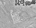
The penitentiary site as seen in 1994
-
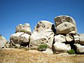
Rock Faces, non-prehistoric petroglyphs in Victorville

See also
 In Spanish: Victorville para niños
