
Hortonville, Wisconsin facts for kids
Quick facts for kids
Hortonville, Wisconsin
|
|
|---|---|
|
Village
|
|

Location of Hortonville in Outagamie County, Wisconsin.
|
|
| Country | |
| State | |
| County | Outagamie |
| Area | |
| • Total | 3.47 sq mi (8.99 km2) |
| • Land | 3.39 sq mi (8.78 km2) |
| • Water | 0.08 sq mi (0.20 km2) |
| Elevation | 794 ft (242 m) |
| Population
(2010)
|
|
| • Total | 2,711 |
| • Estimate
(2019)
|
2,912 |
| • Density | 858.49/sq mi (331.47/km2) |
| Time zone | UTC-6 (Central (CST)) |
| • Summer (DST) | UTC-5 (CDT) |
| Area code(s) | 920 |
| FIPS code | 55-35850 |
| GNIS feature ID | 1566752 |
| Website | Village Website |
Hortonville is a village in Outagamie County, Wisconsin, United States. The population was 2,711 at the 2010 census.
Hortonville is located in the Fox Cities region and the Appleton-Oshkosh-Neenah, WI CSA, the third largest metropolitan area in Wisconsin.
Contents
History
The village was founded in 1848 by landowner Alonzo Horton. One of Horton's first priorities was to dam Black Otter Creek, creating the 75-acre (300,000 m2) Black Otter Lake. After laying out a plat for the community and encouraging development by giving much of the land away, Horton was swayed westward by the California Gold Rush. He later developed the city of San Diego, California.
On August 11, 1894, the settlement was incorporated as the Village of Hortonville. At that time, it had one of the first match light factories in the world.
During World War II, a German POW camp was established in Hortonville along County Hwy MM on the north side of the village.
In 1981, the Hortonville Community Hall, also known as the Hortonville Opera House, was added to the National Register of Historic Places.
Geography
Hortonville is located at 44°20′7″N 88°38′20″W / 44.33528°N 88.63889°W (44.335196, -88.638847).
According to the United States Census Bureau, the village has a total area of 3.55 square miles (9.19 km2), of which, 3.47 square miles (8.99 km2) of it is land and 0.08 square miles (0.21 km2) is water.
Black Otter Lake
The community is located on the shores of the 75-acre (300,000 m2) Black Otter Lake. It is drained by Black Otter Creek, which flows into the Wolf River just north of the village. The total watershed for the lake is estimated to be 16 square miles (41 km2).
The Black Otter is the only public access lake in Outagamie County. Because of this, it receives substantial recreational use, primarily by anglers, throughout the year. Fish species in the lake include: bluegill, largemouth bass, black crappie, yellow perch, northern pike and catfish.
The village maintains a public boat launch, a fishing pier and two parks along the shores of the lake. Black Otter County Park is located on the north shore of the lake and also has a public boat launch.
Demographics
Hortonville is a part of the Appleton-Oshkosh-Neenah CSA, a Combined Statistical Area that includes the Appleton, Wisconsin metropolitan area (Calumet and Outagamie counties) and Oshkosh-Neenah (Winnebago County) metropolitan areas, which had a combined population of 358,365 at the 2000 census.
| Historical population | |||
|---|---|---|---|
| Census | Pop. | %± | |
| 1880 | 311 | — | |
| 1890 | 440 | 41.5% | |
| 1900 | 913 | 107.5% | |
| 1910 | 863 | −5.5% | |
| 1920 | 960 | 11.2% | |
| 1930 | 906 | −5.6% | |
| 1940 | 968 | 6.8% | |
| 1950 | 1,081 | 11.7% | |
| 1960 | 1,366 | 26.4% | |
| 1970 | 1,524 | 11.6% | |
| 1980 | 2,016 | 32.3% | |
| 1990 | 2,029 | 0.6% | |
| 2000 | 2,357 | 16.2% | |
| 2010 | 2,711 | 15.0% | |
| 2019 (est.) | 2,912 | 7.4% | |
| U.S. Decennial Census | |||
2010 census
As of the census of 2010, there were 2,711 people, 1,045 households, and 766 families residing in the village. The population density was 781.3 inhabitants per square mile (301.7/km2). There were 1,105 housing units at an average density of 318.4 per square mile (122.9/km2). The racial makeup of the village was 96.9% White, 0.2% African American, 0.2% Native American, 1.2% Asian, 0.4% from other races, and 1.1% from two or more races. Hispanic or Latino of any race were 1.5% of the population.
There were 1,045 households, of which 38.8% had children under the age of 18 living with them, 57.1% were married couples living together, 10.6% had a female householder with no husband present, 5.6% had a male householder with no wife present, and 26.7% were non-families. 22.0% of all households were made up of individuals, and 7.3% had someone living alone who was 65 years of age or older. The average household size was 2.59 and the average family size was 3.01.
The median age in the village was 36.7 years. 26.9% of residents were under the age of 18; 7.5% were between the ages of 18 and 24; 29% were from 25 to 44; 25.2% were from 45 to 64; and 11.4% were 65 years of age or older. The gender makeup of the village was 49.2% male and 50.8% female.
Transportation
Roads
|
|
WIS 15 (Main Street) travels east to Greenville and Appleton and west to New London. |
|
|
County M (Nash Street and Olk Street) travels north to WIS 54 and south to WIS 96 at Medina. |
|
|
County T travels northwest to New London and south to WIS 96 at Dale. |
|
|
County JJ travels east to Greenville and Kaukauna. |
|
|
County MM (North Crest Street) travels northeast to WIS 76 at Stephensville. |
|
|
County TT travels west to US 45, which was rerouted west of the village in 2003. |
|
|
Rustic Road 61 is a 3.5-mile (5.6 km) state-designated scenic route that follows County MM from Hortonville to Stephensville. |
Airports
- Appleton International Airport (ATW), is located 10 miles (16 km) southeast of Hortonville, and provides commercial airline service to the village.
- Black Otter Airport (9WI1) is a privately owned grass strip, located just east of the Black Otter Lake. Permission is required to land here.
Rail
The Canadian National Railroad operates the former Fox Valley & Western Railroad track along the southern edge of the village, with a freight station near S Nash Street. It also operates 3 crossings - one at W Main Street/ WIS 15, another at S Lincoln Street, and a third at S Nash Street.
Religion
The Wisconsin Evangelical Lutheran Synod has two churches in Hortonville: Bethlehem Lutheran Church and St Paul Lutheran Church. There is also St Peter & Paul Catholic Church.
Points of interest
- Black Otter Lake
- Eagle Creek and Grand View Golf Clubs
- Wiouwash State Trail
- Wolf River
Education
The Hortonville Area School District, which includes a high school, two middle schools and three elementary schools, serves the village and the surrounding communities. Bethlehem Lutheran School is a 4K-8th grade Christian school of the Wisconsin Evangelical Lutheran Synod in Hortonville.
Notable people
- Dave Gassner, professional baseball player
- David Hodgins, Wisconsin legislator
- Isaac N. McComb, Wisconsin legislator and physician
- Charlie Nagreen, inventor of the hamburger
- Gerald Nye, U.S. Senator from North Dakota
- Alexander B. Whitman, Wisconsin legislator
Images for kids
-
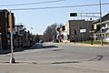
Looking east at downtown Hortonville
-
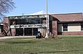
Hortonville High School
-
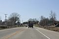
Welcome sign


See also
 In Spanish: Hortonville (Wisconsin) para niños
