
Hot Springs County, Wyoming facts for kids
Quick facts for kids
Hot Springs County
|
||
|---|---|---|

Hot Springs County Courthouse
|
||
|
||

Location within the U.S. state of Wyoming
|
||
 Wyoming's location within the U.S. |
||
| Country | ||
| State | ||
| Founded | February 21, 1911 (established) 1913 (organized) |
|
| Named for | Hot springs in the area | |
| Seat | Thermopolis | |
| Largest town | Thermopolis | |
| Area | ||
| • Total | 2,006 sq mi (5,200 km2) | |
| • Land | 2,004 sq mi (5,190 km2) | |
| • Water | 2.3 sq mi (6 km2) 0.1%% | |
| Population
(2020)
|
||
| • Total | 4,621 | |
| • Estimate
(2019)
|
4,413 | |
| • Density | 2.3036/sq mi (0.8894/km2) | |
| Time zone | UTC−7 (Mountain) | |
| • Summer (DST) | UTC−6 (MDT) | |
| Congressional district | At-large | |

Hot Springs County is a county in the U.S. state of Wyoming. As of the 2020 United States Census, the population was 4,696, making it the second-least populous county in Wyoming. Its county seat is Thermopolis. The county is named for the hot springs located in Hot Springs State Park.
Contents
History
Hot Springs County was created on February 21, 1911 with land detached from Big Horn County, Fremont County, and Park County. It was organized in 1913.
Hot Springs County was named for the hot springs located in the county seat of Thermopolis.
In the 2008 United States presidential election, Hot Springs County was the only county in the entire Mountain West outside of Arizona where John McCain beat George W. Bush's percentage of the county vote from the 2004 election.
Geography
According to the U.S. Census Bureau, the county has a total area of 2,006 square miles (5,200 km2), of which 2,004 square miles (5,190 km2) is land and 2.3 square miles (6.0 km2) (0.1%) is water. It is the smallest county in Wyoming by area and the largest county in the US that is a state's smallest county.
Hot Springs County includes the southern portion of Wyoming's Big Horn Basin, and is surrounded by mountains. Most of the Wind River Canyon, with the Owl Creek Mountains on the west and Bridger Mountains on the east is in Hot Springs County, while the Bighorn Mountains ring the east portion on the county and the Absaroka Range is to the west. A small portion of the Shoshone National Forest lies in the westernmost part of the county.
The Wind River Indian Reservation extends into southern Hot Springs County.
Adjacent counties
- Washakie County (northeast)
- Fremont County (south and southwest)
- Park County (northwest and north)
National protected area
- Shoshone National Forest (part)
Demographics
| Historical population | |||
|---|---|---|---|
| Census | Pop. | %± | |
| 1920 | 5,164 | — | |
| 1930 | 5,476 | 6.0% | |
| 1940 | 4,607 | −15.9% | |
| 1950 | 5,250 | 14.0% | |
| 1960 | 6,365 | 21.2% | |
| 1970 | 4,952 | −22.2% | |
| 1980 | 5,710 | 15.3% | |
| 1990 | 4,809 | −15.8% | |
| 2000 | 4,882 | 1.5% | |
| 2010 | 4,812 | −1.4% | |
| 2020 | 4,621 | −4.0% | |
| US Decennial Census 1870–2000 2010–2016 |
|||
2010 census
As of the 2010 United States Census, there were 4,812 people, 2,185 households, and 1,362 families in the county. The population density was 2.4 inhabitants per square mile (0.93/km2). There were 2,582 housing units at an average density of 1.3 per square mile (0.50/km2). The racial makeup of the county was 95.8% white, 1.5% American Indian, 0.4% Asian, 0.2% black or African American, 0.1% Pacific islander, 0.5% from other races, and 1.5% from two or more races. Those of Hispanic or Latino origin made up 2.2% of the population. In terms of ancestry, 30.1% were German, 15.3% were Irish, 15.1% were English, 8.4% were Scotch-Irish, and 8.3% were American.
Of the 2,185 households, 23.5% had children under the age of 18 living with them, 50.5% were married couples living together, 8.3% had a female householder with no husband present, 37.7% were non-families, and 32.6% of all households were made up of individuals. The average household size was 2.16 and the average family size was 2.70. The median age was 48.6 years.
The median income for a household in the county was $42,469 and the median income for a family was $54,709. Males had a median income of $41,186 versus $26,990 for females. The per capita income for the county was $25,269. About 6.8% of families and 9.1% of the population were below the poverty line, including 12.2% of those under age 18 and 5.7% of those age 65 or over.
Communities
Towns
- East Thermopolis
- Kirby
- Thermopolis (county seat)
Census-designated places
Unincorporated communities
Images for kids
-
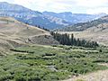
South Fork of Owl Creek

See also
 In Spanish: Condado de Hot Springs para niños
