
Houghton County, Michigan facts for kids
Quick facts for kids
Houghton County
|
||
|---|---|---|

Houghton County Courthouse
|
||
|
||

Location within the U.S. state of Michigan
|
||
 Michigan's location within the U.S. |
||
| Country | ||
| State | ||
| Founded | 1843 (set off) 1845 (boundaries described) 1846 (organized) 1848 (re-organized) |
|
| Named for | Douglass Houghton | |
| Seat | Houghton | |
| Largest city | Houghton | |
| Area | ||
| • Total | 1,502 sq mi (3,890 km2) | |
| • Land | 1,009 sq mi (2,610 km2) | |
| • Water | 492 sq mi (1,270 km2) 33%% | |
| Population
(2020)
|
||
| • Total | 37,361 | |
| • Density | 36/sq mi (14/km2) | |
| Time zone | UTC−5 (Eastern) | |
| • Summer (DST) | UTC−4 (EDT) | |
| Congressional district | 1st | |

Houghton County is a county in the Upper Peninsula in the U.S. state of Michigan. As of the 2020 Census, the population was 37,361. The county seat and largest city is Houghton. Both the county and the city were named for Michigan State geologist and Detroit Mayor Douglass Houghton.
Houghton County is part of the Houghton Micropolitan Statistical Area, which also includes Keweenaw County, and was part of Copper Country during the mining boom of the latter half of the 19th century and the early part of the 20th century.
Contents
Geography
According to the U.S. Census Bureau, the county has an area of 1,502 square miles (3,890 km2), of which 1,009 square miles (2,610 km2) is land and 492 square miles (1,270 km2) (33%) is water.
The Portage Lift Bridge crosses Portage Lake, connecting Hancock and Houghton, Michigan, by crossing over Portage Lake, which is part of the river and canal system that crosses the entire peninsula. The Portage Lift Bridge is the world's heaviest and widest double-decked vertical lift bridge. Its center span "lifts" to provide 100 feet (30 m) of clearance for ships. Since rail traffic was discontinued in the Keweenaw, the lower deck accommodates snowmobile traffic in the winter. This is the only land-based link between the Keweenaw peninsula's north and south sections, making it crucial to local transportation.
Major highways
 US 41
US 41 M-26
M-26 M-28
M-28 M-38
M-38- M-203
- FFH 16
Airport
Prickett-Grooms Field (FAA LID: 6Y9), serves the county and surrounding communities.
Adjacent counties
- Keweenaw County (north)
- Baraga County (east)
- Iron County (south/CST Border)
- Ontonagon County (west)
National protected areas
- Keweenaw National Historical Park (part)
- Ottawa National Forest (part)
Demographics
| Historical population | |||
|---|---|---|---|
| Census | Pop. | %± | |
| 1850 | 708 | — | |
| 1860 | 9,234 | 1,204.2% | |
| 1870 | 13,879 | 50.3% | |
| 1880 | 22,473 | 61.9% | |
| 1890 | 35,389 | 57.5% | |
| 1900 | 66,063 | 86.7% | |
| 1910 | 88,098 | 33.4% | |
| 1920 | 71,930 | −18.4% | |
| 1930 | 52,851 | −26.5% | |
| 1940 | 47,631 | −9.9% | |
| 1950 | 39,771 | −16.5% | |
| 1960 | 35,654 | −10.4% | |
| 1970 | 34,652 | −2.8% | |
| 1980 | 37,872 | 9.3% | |
| 1990 | 35,446 | −6.4% | |
| 2000 | 36,016 | 1.6% | |
| 2010 | 36,628 | 1.7% | |
| 2020 | 37,361 | 2.0% | |
| US Decennial Census 1790-1960 1900-1990 1990-2000 2010-2018 |
|||
The 2010 United States Census indicates Houghton County had a population of 36,628. This is an increase of 612 people from 2000, a growth of 1.7%. In 2010 there were 14,232 households and 8,093 families in the county. The population density was 36 people per square mile (14/km2). There were 18,635 housing units at an average density of 18 per square mile (7/km2). 94.5% of the population were White, 2.9% Asian, 0.6% Native American, 0.5% Black or African American, 0.2% of some other race and 1.3% of two or more races. 1.1% were Hispanic or Latino (of any race). 32.5% were of Finnish, 14.0% German, 9.4% French, 6.2% English and 5.1% Irish ancestry.
There were 14,232 households, out of which 23.4% had children under the age of 18 living with them, 45% were married couples living together, 7.7% had a female householder with no husband present, and 43.1% were non-families. 32.2% of all households were made up of individuals, and 12.6% had someone living alone who was 65 years of age or older. The average household size was 2.38 and the average family size was 3.01.
The county population contained 20.6% under the age of 18, 20.6% from 18 to 24, 20.3% from 25 to 44, 23.6% from 45 to 64, and 15% who were 65 years of age or older. The median age was 33.1 years. The population was 45.9% female and 54.1% male.
The median income for a household in the county was $34,625, and the median income for a family was $48,506. The per capita income for the county was $18,556. About 12.6% of families and 22.8% of the population were below the poverty line, including 21.7% of people under the age of 18 and 9.2% of those age 65 or over.
History
Houghton County's history is heavily marked by immigration. At one of peaks of its population, the 1910 census had 40.6% of its population of 88,098 as foreign born, with 89.3% of the population being either foreign born or having at one or both of their parents as foreign born. Seventy percent (70.6%) of all voters were foreign born, and only 5.1% of voters were native born with native parents. This amalgam of immigrants from dozens of countries created a unique culture, especially once population growth stopped, and the county shrank in population to its current numbers. Heavily representative among many ethnicities were the Finnish. The same 1910 census listed 13.1% of the population having been born in Finland (which is just shy of one third (32.3%) of the population who were foreign-born). It is interesting to note that the 2010 Census lists almost the same proportion (32.5%) of the population as descended from Finnish ancestry.
Communities
Cities
Villages
Census-designated places
Other unincorporated communities
- Atlantic Mine
- Blue Jacket
- Centennial
- Chassell
- Dakota Heights
- Dodgeville
- Donken
- Dreamland
- Franklin Mine
- Freda
- Hurontown
- Jacobsville
- Kearsarge
- Mason
- Painesdale
- Redridge
- Ripley
- Senter
- Tamarack City
- Toivola
- Trimountain
- Twin Lakes
- White City
- Yellow Jacket
Townships
- Adams Township
- Calumet Charter Township
- Chassell Township
- Duncan Township
- Elm River Township
- Franklin Township
- Hancock Township
- Laird Township
- Osceola Township
- Portage Charter Township
- Quincy Township
- Schoolcraft Township
- Stanton Township
- Torch Lake Township
Images for kids
-
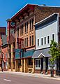
Quincy Street in Hancock, Michigan
-

The Finlandia University in Hancock
-
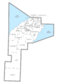
U.S. Census data map showing local municipal boundaries within Houghton County. Shaded areas represent incorporated cities.


See also
 In Spanish: Condado de Houghton para niños
