Howard County, Texas facts for kids
Quick facts for kids
Howard County
|
|
|---|---|

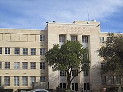
Howard County Court House in downtown Big Spring
|
|

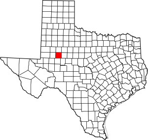
Location within the U.S. state of Texas
|
|
 Texas's location within the U.S. |
|
| Country | |
| State | |
| Founded | 1882 |
| Named for | Volney E. Howard |
| Seat | Big Spring |
| Largest city | Big Spring |
| Area | |
| • Total | 904 sq mi (2,340 km2) |
| • Land | 901 sq mi (2,330 km2) |
| • Water | 3 sq mi (8 km2) 0.4% |
| Population
(2020)
|
|
| • Total | 34,860 |
| • Density | 38.562/sq mi (14.889/km2) |
| Time zone | UTC−6 (Central) |
| • Summer (DST) | UTC−5 (CDT) |
| Congressional district | 19th |
Howard County is a county located in the U.S. state of Texas. At the 2020 census, its population was 34,860. Its county seat is Big Spring. The county was created in 1876 and organized in 1882. It is named for Volney E. Howard, a U.S. Congressman from Texas.
Howard County is included in the Big Spring, Texas Micropolitan Statistical Area.
Contents
Geography
According to the U.S. Census Bureau, the county has a total area of 904 square miles (2,340 km2), of which 901 square miles (2,330 km2) is land and 3.4 square miles (8.8 km2) (0.4%) is water.
Howard County is located at the boundary between the Llano Estacado to the north and the Edwards Plateau to the south. Beals Creek, a tributary of the Colorado River flows through the center of Big Spring and divides these two major physiographic regions.
Major highways
 Interstate 20
 Interstate 20 Business
 U.S. Highway 87
 State Highway 176
 State Highway 350
 Farm to Market Road 669
 Farm to Market Road 700
Adjacent counties
- Borden County (north)
- Mitchell County (east)
- Sterling County (southeast)
- Glasscock County (south)
- Martin County (west)
- Dawson County (northwest)
- Scurry County (northeast)
Demographics
| Historical population | |||
|---|---|---|---|
| Census | Pop. | %± | |
| 1880 | 50 | — | |
| 1890 | 1,210 | 2,320.0% | |
| 1900 | 2,528 | 108.9% | |
| 1910 | 8,881 | 251.3% | |
| 1920 | 6,962 | −21.6% | |
| 1930 | 22,888 | 228.8% | |
| 1940 | 20,990 | −8.3% | |
| 1950 | 26,722 | 27.3% | |
| 1960 | 40,139 | 50.2% | |
| 1970 | 37,796 | −5.8% | |
| 1980 | 33,142 | −12.3% | |
| 1990 | 32,343 | −2.4% | |
| 2000 | 33,627 | 4.0% | |
| 2010 | 35,012 | 4.1% | |
| 2020 | 34,860 | −0.4% | |
| U.S. Decennial Census 1850–2010 2010 2020 |
|||
2020 census
| Race / Ethnicity | Pop 2010 | Pop 2020 | % 2010 | % 2020 |
|---|---|---|---|---|
| White alone (NH) | 18,801 | 15,672 | 53.70% | 44.96% |
| Black or African American alone (NH) | 2,079 | 1,520 | 5.94% | 4.36% |
| Native American or Alaska Native alone (NH) | 220 | 211 | 0.63% | 0.61% |
| Asian alone (NH) | 256 | 386 | 0.73% | 1.11% |
| Pacific Islander alone (NH) | 13 | 12 | 0.04% | 0.03% |
| Some Other Race alone (NH) | 76 | 68 | 0.22% | 0.20% |
| Mixed Race/Multi-Racial (NH) | 312 | 817 | 0.89% | 2.34% |
| Hispanic or Latino (any race) | 13,255 | 16,174 | 37.86% | 46.40% |
| Total | 35,012 | 34,860 | 100.00% | 100.00% |
Note: the US Census treats Hispanic/Latino as an ethnic category. This table excludes Latinos from the racial categories and assigns them to a separate category. Hispanics/Latinos can be of any race.
Communities
Cities
- Big Spring (county seat)
- Forsan
Towns
Census-designated place
Unincorporated communities
Ghost Town
Ross City
See also
 In Spanish: Condado de Howard (Texas) para niños


