
Howth Head facts for kids
|
Ceann Bhinn Éadair
|
|
|---|---|

Aerial view of Howth Head looking south.
|
|
| Geography | |
| Location | Ireland |
| Adjacent bodies of water | |
| Area | 11 km2 (4.2 sq mi) |
| Highest elevation | 171 m (561 ft) |
| Highest point | Ben of Howth |
| Administration | |
| County | Dublin |
| Demographics | |
| Population | 8,294 (2016) |
| Pop. density | 754 /km2 (1,953 /sq mi) |
_Admiralty_Chart_of_1875_updated_to_1931,_copyright_expired_1981.jpg)
Howth Head ( HOHTH; Ceann Bhinn Éadair in Irish) is a peninsula northeast of the city of Dublin in Ireland, within the governance of Fingal County Council. Entry to the headland is at Sutton while the village of Howth and the harbour are on the north-eastern face. Most of Howth Head is occupied by the Hill of Howth, though there are other regions, such as the tombolo at Sutton, extensive beaches on the northern shores, and small ones in other parts. The Baily Lighthouse is on the southeastern part of Howth Head. Nearby are the districts of Baldoyle and Portmarnock, and adjacent is the nature reserve of North Bull Island.
Contents
History
The earliest mention of the peninsula may be on a map attributed to Claudius Ptolemy, where it was called Edri Deserta or in Greek Edrou Heremos (Εδρου ἐρῆμος, Edar's isolated place). Here it was portrayed as an island, but it is not clear if this was due to actual separation from the headland or inaccurate information available to the cartographer. Other writers think that Edrou was actually Lambay Island, from Greek ἑδρα (hedra) "sitting place [for ships]".
The peninsula has been occupied since at least the 3rd millennium B.C.E., with two middens found, and a dolmen dating back to around 2200 B.C.E. It features in a range of Irish legends. A fishing settlement developed at Howth, and the area developed under the Norman St. Lawrence family, who owned most of Howth Head from the late 1100s until 2019. In the 19th century, an electric tramline made the whole hill more accessible.
Location and topography
Originally an island, Howth Head is connected to the mainland via a narrow strip of land, or tombolo, and forms the northerly bound of the great crescent of Dublin Bay, roughly corresponding to Dalkey Hill and Killiney Hill in the south.
Most of the headland is hilly, with peaks such as the 171 m Black Linn, by the Ben of Howth, on a side road beyond the Green Hill Quarries at the Loughereen Hills, Shielmartin Hill (163 m) overlooking Carrickbrack Road and Carrickbrack and Dun Hill. There are also craggy areas such as Muck Rock (Carrickmore), and Kilrock.
Howth has an extensive and varied coastline, and there are steep sea cliffs around parts, especially on the north coast. Key points on the coast, clockwise from Sutton, include Cush Point, Claremont Strand, the small headland at Howth village, Balscadden Bay, Kilrock, the Great and Little Baily, Lion's Head, Doldrum Bay, the Needles, Drumleck Point, Red Rock and Sutton Strand.
Due to the shape of the landform, and its rocky nature, with thin soil covering, Howth features multiple streams, several fast-running streams, due to hard rock under a thin soil layer. These include the Bloody StreamCoulcour Brook, the Boggeen Stream, and the Offington Stream, and the Whitewater Brook, the Balsaggart Stream, and the Carrickbrack and Santa Sabina Streams.
Fauna and flora
The cliffs support a large colony of seabirds, notably razorbills, common guillemots, fulmars, kittiwakes and cormorants. The scrubland above supports several heathland species including skylarks, meadow pipits, whitethroats, linnets, stonechats and whinchats. The most commonly seen birds of prey are kestrels, peregrine falcons and common buzzards.
Gorse grows in many places on the headland. Fires are frequent during dry summers.
Transport
There are two railway stations on or near the head. Sutton station is on the northern edge of the tombolo between Sutton and Baldoyle, and Howth station is on the head in the village of Howth. Both are served by Dublin Area Rapid Transit trains and have regular services to and from Dublin city centre. Historically the Hill of Howth Tramway ran between the stations around the head between 1901 and 1959. Additionally Dublin Bus routes serve the headland. A full road network accesses most parts, although some are only reachable by some of the many footpaths.
Gallery
-
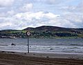
Howth Head viewed from on the North Bull Island in Dublin Bay
-
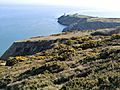
Cliffs at Howth Head with Baily Lighthouse in the distance
-
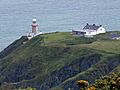
Baily Lighthouse at southeast end of Howth Head
-
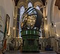
Optic from Baily lighthouse, installed in 1902 and removed in 1972 when the lighthouse was modernised
-
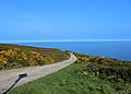
Walk on Howth Head


.jpg)

Leisure
Howth is a popular destination for day-trippers from the capital, accessible by car, bus and one of the northern termini of the Dublin Area Rapid Transit train system (DART). Hikers can choose from a wide range of routes, including the Cliff Walk, the Cliff Path Closed Loop, or making for the ancient cairn on one of Howth's several summits. On clear days, the Wicklow Mountains can be seen, with Dublin city below. Slieve Donard, an 852-metre peak in Northern Ireland may also be visible - a distance of 90 km (56 mi). Quite frequently, Snowdon (1,085 m) in Snowdonia National Park in Wales can also be seen - a distance of 138 km (86 mi).
Images for kids
-

Painting by Sir William Orpen - Grace reading at Howth Bay

See also
 In Spanish: Cabo de Howth para niños
