
Hughenden, Queensland facts for kids
Quick facts for kids HughendenQueensland |
|||||||||||||||
|---|---|---|---|---|---|---|---|---|---|---|---|---|---|---|---|

Hughenden's dinosaur statue
|
|||||||||||||||

Hughenden
Location in Queensland
|
|||||||||||||||
| Population | 1,136 (2016 census) | ||||||||||||||
| • Density | 1.2193/km2 (3.158/sq mi) | ||||||||||||||
| Established | 1870 | ||||||||||||||
| Postcode(s) | 4821 | ||||||||||||||
| Elevation | 324.0 m (1,063 ft) | ||||||||||||||
| Area | 931.7 km2 (359.7 sq mi) | ||||||||||||||
| Time zone | AEST (UTC+10:00) | ||||||||||||||
| Location |
|
||||||||||||||
| LGA(s) | Flinders Shire | ||||||||||||||
| County | Douglas | ||||||||||||||
| State electorate(s) | Traeger | ||||||||||||||
| Federal Division(s) | Kennedy | ||||||||||||||
|
|||||||||||||||
|
|||||||||||||||
Hughenden is a rural town and locality in the Flinders Shire, Queensland, Australia. In the 2016 census, the locality of Hughenden had a population of 1,136 people.
Contents
History
Hughenden Post Office opened on 1 July 1878 (a receiving office had been open from 1874).
Torrens Creek near Hughenden is where the Americans stored explosives in World War II. The Americans didn't know of the dangerous bush fires out there. After they put out a fire they went back to camp thinking that the fire was out. However, the fire took hold again without them knowing. They then heard about twelve major explosions in succession; the explosions left craters twenty feet deep. Hot shrapnel covered a wide area and started more fires. In the townships, people said that buildings shook and windows broke, and some people were convinced that an air raid had occurred. Thousands of soldiers and civilians attacked the blaze in an attempt to stop it spreading to fuel dumps, but were unable to control it. When the fire got to the explosives it was so powerful it blew the Americans out of their trucks. Many buildings and shops got burnt down from the spreading fires. However the locals were able to save the post office. A police Constable from Torrens Creek Police was awarded the King’s Medal of Bravery.
Heritage listings
Hughenden has a number of heritage-listed sites, including:
- 25 Gray Street: The Grand Hotel, which was damaged extensively in a fire in 2011
Geography
Hughenden is located on the Flinders Highway, 376 kilometres (234 mi) west of Townsville and 1,400 kilometres (870 mi) north-west of Brisbane, the state capital. The region around Hughenden is a major centre for the grazing of sheep and cattle. The main feed is annual grasses known as Flinders grass, which grow rapidly on the (by Australian standards) fertile grey or brown cracking clay soils after rain between November and March. However, because the rainfall is extremely erratic — at Hughenden itself it has ranged from 126 millimetres (5 in) in 1926 to 1,051 millimetres (41 in) in 1950 — droughts and floods are normal and stock number fluctuate greatly.
The runoff from the Flinders River is much too erratic to provide a sustainable supply for any crop-growing via irrigation.
Climate
Hughenden has a dry, tropical climate. Record temperatures have varied from around 44 °C (111 °F) in the summer months to as low as −2 °C (28 °F) in winter, but average maximum temperatures are usually a very hot 36 °C (97 °F) in summer and a very warm 25 °C (77 °F) in June and July. Minima range from 22 °C (72 °F) in summer to around 10 °C (50 °F) in winter. On average, a minimum below 2 °C (36 °F) is recorded once per year.
The average annual rainfall is around 490 millimetres (19 in), of which over three-quarters falls from November to March. Between May and September, rainfall is extremely rare: the median rainfall is zero in August, less than 2 millimetres (0.1 in) in July and September and less than 10 millimetres (0.4 in) in April, May, June and October. Variability is extreme, however, and totals as high as 800 millimetres (31 in) occur roughly one year in ten, whilst in the driest years as little as 127 millimetres (5 in) can be recorded. Between December and March, monthly totals can exceed 330 millimetres (13 in) if the monsoon is vigorous.
Humidity is generally low except when the monsoon is active, when relatively lower temperatures accompany high humidity. The same applies to cloudiness: in the dry winter months over twenty days are completely clear.
| Climate data for Hughenden Post Office | |||||||||||||
|---|---|---|---|---|---|---|---|---|---|---|---|---|---|
| Month | Jan | Feb | Mar | Apr | May | Jun | Jul | Aug | Sep | Oct | Nov | Dec | Year |
| Record high °C (°F) | 43.6 (110.5) |
42.8 (109.0) |
40.1 (104.2) |
37.8 (100.0) |
33.6 (92.5) |
33.5 (92.3) |
34.3 (93.7) |
36.1 (97.0) |
39.3 (102.7) |
40.4 (104.7) |
43.9 (111.0) |
44.0 (111.2) |
44.0 (111.2) |
| Average high °C (°F) | 35.8 (96.4) |
34.7 (94.5) |
33.7 (92.7) |
31.4 (88.5) |
27.9 (82.2) |
25.0 (77.0) |
25.0 (77.0) |
27.5 (81.5) |
31.1 (88.0) |
34.5 (94.1) |
36.1 (97.0) |
36.9 (98.4) |
31.6 (88.9) |
| Average low °C (°F) | 22.5 (72.5) |
22.1 (71.8) |
20.5 (68.9) |
17.0 (62.6) |
13.2 (55.8) |
9.8 (49.6) |
8.8 (47.8) |
10.4 (50.7) |
14.0 (57.2) |
18.0 (64.4) |
20.5 (68.9) |
22.0 (71.6) |
16.6 (61.9) |
| Record low °C (°F) | 15.4 (59.7) |
15.2 (59.4) |
11.1 (52.0) |
7.2 (45.0) |
2.3 (36.1) |
0.0 (32.0) |
−2.0 (28.4) |
−1.4 (29.5) |
4.8 (40.6) |
7.0 (44.6) |
10.5 (50.9) |
14.6 (58.3) |
−2.0 (28.4) |
| Average rainfall mm (inches) | 114.5 (4.51) |
98.0 (3.86) |
58.2 (2.29) |
26.0 (1.02) |
17.8 (0.70) |
18.6 (0.73) |
11.6 (0.46) |
7.9 (0.31) |
9.0 (0.35) |
22.3 (0.88) |
36.0 (1.42) |
71.1 (2.80) |
491 (19.33) |
| Average rainy days (≥ 0.2mm) | 8.2 | 7.6 | 4.7 | 2.3 | 1.8 | 1.8 | 1.4 | 0.9 | 1.3 | 2.7 | 4.3 | 6.0 | 43 |
| Source: Bureau of Meteorology | |||||||||||||
Demographics
The Flinders Shire covers an area of 41,632 square kilometres (16,074 sq mi). The population of the Flinders Shire from the 1996 Census was 2,222. yet according to the 2001 Census the Shire population was 2,152 and in 2006 it is 1,356. Urban Hughenden's estimated population as of June 2006 is 1,154.
Planned growth
It is thought that by the year 2025, Hughenden will be a very different town. The Council and community groups have discussed putting in place a range of initiatives so that Hughenden’s future is positive. Hughenden has taken advantage of being at the crossroads of two major highways. Land sales in Hughenden Industrial Estate have shown high growth with Stage 1 all sold and stage 2 and 3 being rushed through the Council so the next development can start. With the Industrial Estate growing, residential growth will also grow, making Hughenden well placed for growth.
Facilities
Hughenden has a visitor information centre, library, showground, shire hall, and racecourse.
Attractions
Apart from agricultural business, Hughenden also boasts a replica of the Muttaburrasaurus, a dinosaur, whose bones were discovered in 1963 near Muttaburra (220 km by road from Hughenden)and some teeth and other bones were also discovered around Hughenden. One reason for fossils being discovered must be the dry climate, which means the rocks are usually bare of vegetation. The town is home to the Hughenden Dinosaur Festival, which attracts tourists and includes entertainment and other events. Other annual events include the Hughenden Show, held the first weekend in June; the Hughenden Country Music Festival, held every Easter week end and the Bullride and Race Day which is held in September. The Matron's Ball is also a popular annual event. In August 2008, Hughenden hosted the first Arid Lands Festival and The Great Hughenden Camel Endurance Challenge.
Transport
- Hughenden Airport
| Preceding station | Queensland Rail | Following station | ||
|---|---|---|---|---|
| Long distance rail services | ||||
| Torrens Creek
towards Townsville
|
The Inlander | Richmond
towards Mount Isa
|
||
Education
Hughenden State School is a government primary and secondary (Prep-12) school for boys and girls at 12 Moran Street (20°50′45″S 144°11′47″E / 20.8459°S 144.1965°E). In 2018, the school had an enrolment of 115 students with 15 teachers and 13 non-teaching staff (11 full-time equivalent).
St Francis Catholic School is a Catholic primary (Prep-6) school for boys and girls at 8 Flinders Street (20°50′46″S 144°12′07″E / 20.8461°S 144.2020°E). In 2018, the school had an enrolment of 41 students with 4 teachers and 4 non-teaching staff (3 full-time equivalent).
Images for kids
-
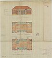
Architectural plans for the two-storey court house drawn up in 1945, a project which was abandoned when it was discovered that the foundations could not support a 2-storey building
-
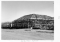
The partly-built one-storey court house, 1952


