Humphreys County, Tennessee facts for kids
Quick facts for kids
Humphreys County
|
|
|---|---|

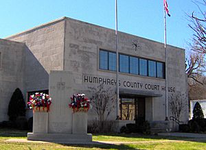
Humphreys County Courthouse in Waverly
|
|

Location within the U.S. state of Tennessee
|
|
 Tennessee's location within the U.S. |
|
| Country | |
| State | |
| Founded | 1809 |
| Named for | Parry Wayne Humphreys |
| Seat | Waverly |
| Largest city | Waverly |
| Area | |
| • Total | 557 sq mi (1,440 km2) |
| • Land | 531 sq mi (1,380 km2) |
| • Water | 26 sq mi (70 km2) 4.6%% |
| Population
(2020)
|
|
| • Total | 18,990 |
| • Density | 35/sq mi (14/km2) |
| Time zone | UTC−6 (Central) |
| • Summer (DST) | UTC−5 (CDT) |
| Congressional district | 7th |
Humphreys County is a county located in the western part of Middle Tennessee, in the U.S. state of Tennessee. As of the 2010 census, the population was 18,538. Its county seat is Waverly.
Contents
History
Humphreys County was established in 1809 from parts of Stewart County, and named for Judge (and future Congressman) Parry Wayne Humphreys. The county seat was initially located at Reynoldsburg, near the mouth of Dry Creek. When the western half of the county was split off to form Benton County in 1835, the seat was moved to the more centrally located Waverly.
During the Civil War, the Battle of Johnsonville took place in the western half of the county. The remnants of the battle site are the focus of Johnsonville State Historic Park.
Geography
According to the U.S. Census Bureau, the county has a total area of 557 square miles (1,440 km2), of which 531 square miles (1,380 km2) is land and 26 square miles (67 km2) (4.6%) is water.
Adjacent counties
- Houston County (north)
- Dickson County (northeast)
- Hickman County (southeast)
- Perry County (south)
- Benton County (west)
National protected area
State protected area
- Johnsonville State Park
Demographics
| Historical population | |||
|---|---|---|---|
| Census | Pop. | %± | |
| 1810 | 1,511 | — | |
| 1820 | 4,067 | 169.2% | |
| 1830 | 6,187 | 52.1% | |
| 1840 | 5,195 | −16.0% | |
| 1850 | 6,422 | 23.6% | |
| 1860 | 9,096 | 41.6% | |
| 1870 | 9,326 | 2.5% | |
| 1880 | 11,379 | 22.0% | |
| 1890 | 11,720 | 3.0% | |
| 1900 | 13,398 | 14.3% | |
| 1910 | 13,908 | 3.8% | |
| 1920 | 13,482 | −3.1% | |
| 1930 | 12,039 | −10.7% | |
| 1940 | 12,421 | 3.2% | |
| 1950 | 11,030 | −11.2% | |
| 1960 | 11,511 | 4.4% | |
| 1970 | 13,560 | 17.8% | |
| 1980 | 15,957 | 17.7% | |
| 1990 | 15,795 | −1.0% | |
| 2000 | 17,929 | 13.5% | |
| 2010 | 18,538 | 3.4% | |
| 2020 | 18,990 | 2.4% | |
| U.S. Decennial Census 1790-1960 1900-1990 1990-2000 2010-2014 |
|||
2020 census
| Race | Number | Percentage |
|---|---|---|
| White (non-Hispanic) | 17,102 | 90.06% |
| Black or African American (non-Hispanic) | 494 | 2.6% |
| Native American | 43 | 0.23% |
| Asian | 57 | 0.3% |
| Other/Mixed | 845 | 4.45% |
| Hispanic or Latino | 449 | 2.36% |
As of the 2020 United States census, there were 18,990 people, 6,763 households, and 4,375 families residing in the county.
Communities
Cities
- McEwen
- New Johnsonville
- Waverly (county seat)
Unincorporated communities
See also
 In Spanish: Condado de Humphreys (Tennessee) para niños


