
Huntington, Massachusetts facts for kids
Quick facts for kids
Huntington
|
||
|---|---|---|

Huntington Country Store
|
||
|
||

Location in Hampshire County in Massachusetts
|
||
| Country | United States | |
| State | Massachusetts | |
| County | Hampshire | |
| Settled | 1769 | |
| Incorporated (Norwich) | 1775 | |
| Incorporated (Huntington) | March 5, 1855 | |
| Government | ||
| • Type | Open town meeting | |
| Area | ||
| • Total | 26.8 sq mi (69.4 km2) | |
| • Land | 26.3 sq mi (68.2 km2) | |
| • Water | 0.5 sq mi (1.2 km2) | |
| Elevation | 382 ft (116 m) | |
| Population
(2020)
|
||
| • Total | 2,094 | |
| • Density | 78.15/sq mi (30.173/km2) | |
| Time zone | UTC-5 (Eastern) | |
| • Summer (DST) | UTC-4 (Eastern) | |
| ZIP Code |
01050
|
|
| Area code(s) | 413 | |
| FIPS code | 25-31785 | |
| GNIS feature ID | 0618203 | |

Huntington is a town in Hampshire County, Massachusetts, United States. The population was 2,094 at the 2020 census. It is part of the Springfield, Massachusetts Metropolitan Statistical Area.
Contents
History
Originally Plantation Number 9. by the Court of Massachusetts Bay, Huntington has a colorful history, hinted at by the town's incorporation date of March 5th, 1855, decades later than the towns around it. The town was assembled from pieces of surrounding towns, which were grafted onto the town of Norwich, Murrayfield, and Knightville . The present village center sits on what was the meeting point of three towns and two counties. The location of the village created a tangle of jurisdictional confusion. With the coming of the railroad in the 1840s and the expansion of industry and population that came with it, the political difficulties that the boundaries presented became untenable.
The solution that resulted in the town we call home today was crafted by a Northampton attorney named Charles Huntington. Once the new town was incorporated, Mr. Huntington presented it with a gift that was the foundation of the town's library. After some discussion, the newly formed town voted to adopt the name of 'Huntington', in honor of its recent architect and benefactor.
Geography
According to the United States Census Bureau, the town has a total area of 26.9 square miles (70 km2), of which 26.6 square miles (69 km2) is land and 0.3 square miles (0.78 km2) (1.00%) is water.
Demographics
| Historical population | ||
|---|---|---|
| Year | Pop. | ±% |
| 1860 | 1,216 | — |
| 1870 | 1,156 | −4.9% |
| 1880 | 1,236 | +6.9% |
| 1890 | 1,385 | +12.1% |
| 1900 | 1,475 | +6.5% |
| 1910 | 1,473 | −0.1% |
| 1920 | 1,425 | −3.3% |
| 1930 | 1,242 | −12.8% |
| 1940 | 1,340 | +7.9% |
| 1950 | 1,257 | −6.2% |
| 1960 | 1,392 | +10.7% |
| 1970 | 1,593 | +14.4% |
| 1980 | 1,804 | +13.2% |
| 1990 | 1,987 | +10.1% |
| 2000 | 2,174 | +9.4% |
| 2010 | 2,180 | +0.3% |
| 2020 | 2,094 | −3.9% |
| * = population estimate. Source: United States Census records and Population Estimates Program data. | ||
As of the census of 2000, there were 2,174 people, 809 households, and 597 families residing in the town. The population density was 81.6 people per square mile (31.5/km2). There were 935 housing units at an average density of 35.1 per square mile (13.6/km2). The racial makeup of the town was 97.56% White, 0.41% African American, 0.18% Native American, 0.41% Asian, 0.28% from other races, and 1.15% from two or more races. Hispanic or Latino of any race were 1.84% of the population.
There were 809 households, out of which 35.0% had children under the age of 18 living with them, 60.4% were married couples living together, 8.9% had a female householder with no husband present, and 26.2% were non-families. 19.2% of all households were made up of individuals, and 6.8% had someone living alone who was 65 years of age or older. The average household size was 2.69 and the average family size was 3.10.
In the town, the population was spread out, with 27.7% under the age of 18, 6.4% from 18 to 24, 30.0% from 25 to 44, 26.1% from 45 to 64, and 9.7% who were 65 years of age or older. The median age was 37 years. For every 100 females, there were 98.5 males. For every 100 females age 18 and over, there were 98.2 males.
The median income for a household in the town was $48,958, and the median income for a family was $52,308. Males had a median income of $36,893 versus $27,414 for females. The per capita income for the town was $19,385. About 4.4% of families and 5.8% of the population were below the poverty line, including 6.2% of those under age 18 and 10.7% of those age 65 or over.
Images for kids
-
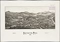
Print of Huntington by L.R. Burleigh from 1886 with listing of sights
.jpg)
See also
 In Spanish: Huntington (Massachusetts) para niños
