
Huntington, Oregon facts for kids
Quick facts for kids
Huntington, Oregon
|
|
|---|---|

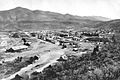
Looking north from Huntington
|
|

Location in Oregon
|
|
| Country | United States |
| State | Oregon |
| County | Baker |
| Incorporated | 1891 |
| Area | |
| • Total | 0.75 sq mi (1.94 km2) |
| • Land | 0.75 sq mi (1.94 km2) |
| • Water | 0.00 sq mi (0.00 km2) |
| Elevation | 2,119 ft (646 m) |
| Population
(2010)
|
|
| • Total | 440 |
| • Estimate
(2019)
|
436 |
| • Density | 582.89/sq mi (225.04/km2) |
| Time zone | UTC-8 (Pacific) |
| • Summer (DST) | UTC-7 (Pacific) |
| ZIP code |
97907
|
| Area code(s) | 541 |
| FIPS code | 41-35700 |
| GNIS feature ID | 1122160 |
Huntington is a city in Baker County, on the eastern border of Oregon, United States. It is located on the Snake River and along Interstate 84 and U.S. Route 30. The population was 440 at the 2010 census, down from 515 in 2000.
Contents
History
Henry Miller settled in the area in August 1862. In 1870, Miller's Stagecoach Station was established According to Oregon Geographic Names, Huntington was named for J.B. and J.M. Huntington, brothers who purchased Miller's holdings in 1882.
The Huntingtons maintained a small trading post on their land. The Oregon Construction Company followed soon, with a stock of general merchandise, a blacksmith shop, the Pacific Hotel, several boarding houses and restaurants and a number of saloons.
In 1898, the Northwest Railroad Company began extending a short line down the Snake River. It reached Homestead about 1910. This increased transportation at Huntington and gave an outlet for Eagle and Pine Valley fruits, cattle, lumber and ore. This line was flooded by water from Brownlee Dam.
Huntington became the only incorporated city in Baker County on the Oregon Trail in 1891 with Home Rule Law.
Remnants of the Old Oregon Trail can still be seen today when one is traveling north from Farewell Bend State Recreation Area toward the town of Huntington on U.S. Route 30.
Evidence of the hardships and tragedies of the pioneer movement still exists: a small iron cross, visible from Route 30, marks the location where Snake River Shoshone Indians killed a number of emigrants in 1860.
At the turn of the century, Huntington developed a reputation as "Sin City", a rugged frontier town having its share of saloons, Chinese opium dens, and gunslingers.
Governor Oswald West was motivated to clean up the city, along with the community of Copperfield, in 1912–14.
The first ransom bill from the 1935 George Weyerhaeuser kidnapping turned up in Huntington.
Geography
According to the United States Census Bureau, the city has a total area of 0.75 square miles (1.94 km2), all of it land. Huntington is across the Snake River from the westernmost point of Idaho.
Climate
| Climate data for Huntington, Oregon | |||||||||||||
|---|---|---|---|---|---|---|---|---|---|---|---|---|---|
| Month | Jan | Feb | Mar | Apr | May | Jun | Jul | Aug | Sep | Oct | Nov | Dec | Year |
| Record high °F (°C) | 69 (21) |
68 (20) |
83 (28) |
94 (34) |
104 (40) |
108 (42) |
113 (45) |
115 (46) |
106 (41) |
94 (34) |
80 (27) |
71 (22) |
115 (46) |
| Average high °F (°C) | 36.8 (2.7) |
44.1 (6.7) |
55.2 (12.9) |
65.3 (18.5) |
74.7 (23.7) |
83.3 (28.5) |
94.2 (34.6) |
92.4 (33.6) |
80.9 (27.2) |
67.1 (19.5) |
49.8 (9.9) |
38.8 (3.8) |
65.2 (18.4) |
| Daily mean °F (°C) | 28.3 (−2.1) |
34.5 (1.4) |
43.6 (6.4) |
52.0 (11.1) |
60.9 (16.1) |
69.2 (20.7) |
79.0 (26.1) |
77.0 (25.0) |
65.6 (18.7) |
52.7 (11.5) |
38.9 (3.8) |
30.3 (−0.9) |
52.7 (11.5) |
| Average low °F (°C) | 20.0 (−6.7) |
24.9 (−3.9) |
31.9 (−0.1) |
38.7 (3.7) |
47.1 (8.4) |
55.2 (12.9) |
64.0 (17.8) |
61.5 (16.4) |
50.1 (10.1) |
38.4 (3.6) |
28.2 (−2.1) |
22.0 (−5.6) |
40.2 (4.6) |
| Record low °F (°C) | −19 (−28) |
−19 (−28) |
5 (−15) |
12 (−11) |
10 (−12) |
28 (−2) |
40 (4) |
31 (−1) |
27 (−3) |
14 (−10) |
−8 (−22) |
−17 (−27) |
−19 (−28) |
| Average precipitation inches (mm) | 1.73 (44) |
1.47 (37) |
1.14 (29) |
0.85 (22) |
1.00 (25) |
0.85 (22) |
0.34 (8.6) |
0.38 (9.7) |
0.45 (11) |
0.70 (18) |
1.47 (37) |
1.82 (46) |
12.19 (310) |
| Average snowfall inches (cm) | 11.5 (29) |
4.7 (12) |
1.0 (2.5) |
0.1 (0.25) |
0.0 (0.0) |
0.0 (0.0) |
0.0 (0.0) |
0.0 (0.0) |
0.0 (0.0) |
0.1 (0.25) |
2.3 (5.8) |
8.1 (21) |
27.6 (70) |
| Average precipitation days | 9 | 8 | 7 | 6 | 6 | 5 | 2 | 2 | 3 | 4 | 8 | 9 | 68 |
Demographics
| Historical population | |||
|---|---|---|---|
| Census | Pop. | %± | |
| 1880 | 200 | — | |
| 1890 | 321 | 60.5% | |
| 1900 | 821 | 155.8% | |
| 1910 | 680 | −17.2% | |
| 1920 | 666 | −2.1% | |
| 1930 | 803 | 20.6% | |
| 1940 | 741 | −7.7% | |
| 1950 | 733 | −1.1% | |
| 1960 | 689 | −6.0% | |
| 1970 | 507 | −26.4% | |
| 1980 | 539 | 6.3% | |
| 1990 | 522 | −3.2% | |
| 2000 | 515 | −1.3% | |
| 2010 | 440 | −14.6% | |
| 2019 (est.) | 436 | −0.9% | |
| source: | |||

2010 census
As of the census of 2010, there were 440 people, 211 households, and 112 families residing in the city. The population density was 586.7 inhabitants per square mile (226.5/km2). There were 272 housing units at an average density of 362.7 per square mile (140.0/km2). The racial makeup of the city was 92.3% White, 0.2% African American, 3.9% Native American, 0.7% Asian, 0.5% from other races, and 2.5% from two or more races. Hispanic or Latino of any race were 1.8% of the population.
There were 211 households, of which 16.6% had children under the age of 18 living with them, 42.2% were married couples living together, 5.2% had a female householder with no husband present, 5.7% had a male householder with no wife present, and 46.9% were non-families. 38.9% of all households were made up of individuals, and 17.1% had someone living alone who was 65 years of age or older. The average household size was 2.09 and the average family size was 2.78.
The median age in the city was 54 years. 16.6% of residents were under the age of 18; 6.2% were between the ages of 18 and 24; 16% were from 25 to 44; 30.7% were from 45 to 64; and 30.7% were 65 years of age or older. The gender makeup of the city was 51.8% male and 48.2% female.
Points of interest
- Farewell Bend State Recreation Area is south of Huntington.
Education
- Huntington High School
Images for kids
-
Huntington, circa 1890
.jpg)
See also
 In Spanish: Huntington (Oregón) para niños
