
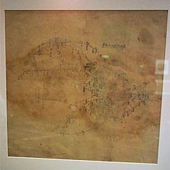
Image: 中国工农红军红星司令部在抢渡湘江前绘制的地图 03572

Size of this preview: 599 × 599 pixels. Other resolutions: 240 × 240 pixels | 3,857 × 3,858 pixels.
Original image (3,857 × 3,858 pixels, file size: 2.55 MB, MIME type: image/jpeg)
Description: 1934年11月底,中央红军战斗五天,从湘江上游全州、兴安之间抢渡湘江,突破了国民党军的封锁线。这是中国工农红军红星司令部为抢渡湘江绘制的《灌(阳)兴(安)全(州)之间的路线图》
Title: 中国工农红军红星司令部在抢渡湘江前绘制的地图 03572
Credit: Own work
Author: Cangminzho
Usage Terms: Creative Commons Attribution-Share Alike 4.0
License: CC BY-SA 4.0
License Link: https://creativecommons.org/licenses/by-sa/4.0
Attribution Required?: Yes
Image usage
The following page links to this image:

All content from Kiddle encyclopedia articles (including the article images and facts) can be freely used under Attribution-ShareAlike license, unless stated otherwise.