
Image: 001 Kievan Rus' Kyivan Rus' Ukraine map 1220 1240

Size of this preview: 483 × 599 pixels. Other resolutions: 193 × 240 pixels | 2,301 × 2,856 pixels.
Original image (2,301 × 2,856 pixels, file size: 4.69 MB, MIME type: image/jpeg)
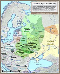
Description: Historical map of Kievan Rus': last 20 years of the state (1220-1240), english version.
Title: 001 Kievan Rus' Kyivan Rus' Ukraine map 1220 1240
Credit: Own work - Other example of similar map: http://izbornyk.org.ua/litop/map_1240.htm
Author: SeikoEn
Usage Terms: Creative Commons Attribution-Share Alike 3.0
License: CC-BY-SA-3.0
License Link: http://creativecommons.org/licenses/by-sa/3.0/
Attribution Required?: Yes
Image usage
The following 3 pages link to this image:

All content from Kiddle encyclopedia articles (including the article images and facts) can be freely used under Attribution-ShareAlike license, unless stated otherwise.