
Image: 12th-century map of the Indian Ocean by Al-Idrisi
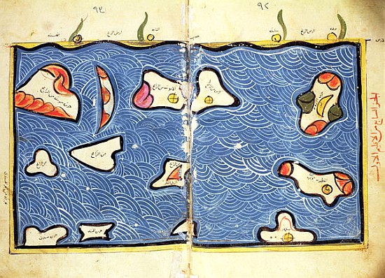
Description: This 12th-century map of the Indian Ocean by al-Idrisi is so obviously imprecise as to seem almost decorative. (Note its similarity to the islands of the Indian Ocean in his world map) But don’t fault him for trying: It was one thing to be able to sail all the way to China and quite another to explain to a stay-at-home scholar where one had been. It is easy to forget what an achievement even a simple map represented. Until the 15th century, mariners knew maps could indicate relative shapes and sizes, but they were nearly useless for navigation. NATIONAL LIBRARY, CAIRO / GIRAUDON / ART RESOURCE
Title: 12th-century map of the Indian Ocean by Al-Idrisi
Credit: NATIONAL LIBRARY, CAIRO / GIRAUDON / ART RESOURCE http://www.art-prints-on-demand.com/a/al-idrisioredrisi-1/theindianoceanfromanatlas-1.html
Author: Muhammad al-Idrisi(1099–1165 or 1166)
Usage Terms: Public domain
License: Public domain
Attribution Required?: No
Image usage
The following page links to this image:
