
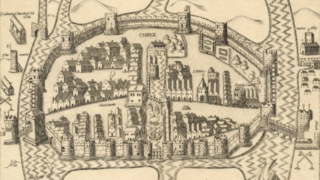
Image: 16th Century Map of Cork - Extracted and replicated from Pacata Hibernia page 137

Size of this preview: 800 × 449 pixels. Other resolutions: 320 × 180 pixels | 2,296 × 1,290 pixels.
Original image (2,296 × 1,290 pixels, file size: 2.4 MB, MIME type: image/png)
Description: Late 16th (early 17th) century map of Cork. Extracted and replicated from Stafford's Pacata Hibernia. Page 137.
Title: 16th Century Map of Cork - Extracted and replicated from Pacata Hibernia page 137
Credit: Pacata Hibernia (formally 'Pacata Hibernia : or, A history of the wars in Ireland during the reign of Queen Elizabeth, especially within the province of Munster under the government of Sir George Carew, and compiled by his direction and appointment). Page 137. Folio page titled "Map of Cork". Cropped to landscape orientation.
Author: Sir Thomas Stafford (c.1574-1655)
Usage Terms: Public domain
License: Public domain
Attribution Required?: No
Image usage
The following page links to this image:

All content from Kiddle encyclopedia articles (including the article images and facts) can be freely used under Attribution-ShareAlike license, unless stated otherwise.