
Image: 1716 Homann Map of Ireland - Geographicus - Ireland-homann-1716

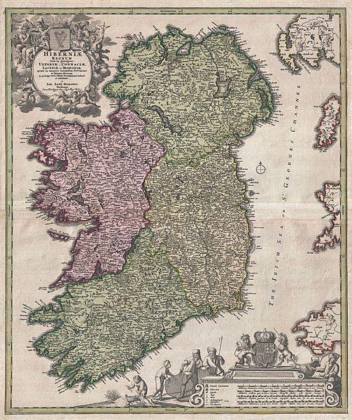
Description: An iconic c. 1716 map of Ireland by Johann Baptist Homann. A fine example of Homann's work, this map bears all of the distinctive hallmarks of Homann's style at the height of his career: a strong dark impression, heavy yet detailed engraving work, elaborate allegorical title cartouches, and a rich but tasteful application of color. The prototype of this map was drawn in 1689 by the Amsterdam cartographer Nicholas Visscher II, who Homann credits in the title cartouche. Visscher's map became the model for most future maps of Ireland well into the late 18th century. Homann revised and updated this map to reflect early 18th century changes to the island. Here Ireland is divided into its four provinces, Munster, Connought (Connacht), Leinster (Lenister) and Ulster, then subdivided into numerous counties. Roads, mountains, forests, swamps, rivers, lakes, bridges towns, and even some offshore details are noted. The elaborate title cartouche in the upper right is rich with Gaelic iconography, including the Gaelic Harp and allegorical representations of Pan, a Celtic adaptation of the Roman god Bacchus, and Brigit, the Celtic goddess of poetry, healing and agriculture. Another cartouche in the lower right hand quadrant frames the map's key and four distance scales. Here we see four fisherman pulling in the day's haul, a clear nod to Visscher, who's Dutch name translates to Fisherman. Above the map key itself is the royal crest of the United Kingdom, who at the time laid claim to Ireland. This map was published in various editions from about 1710 to 1750. The addition of Homann's Privilege to the title cartouche suggest this may be the second state of this map, published sometime between 1715 and Homann's death in 1720. In all a fine map example of Homann's work and an important and influential map of Ireland. Homann erroneously shades County Clare as part of Connought - it had been returned to Munster in 1660.
Title: Hiberniae Regnum tam in Praecipuas Ultoniae, Connaciae, Laceniae et Momoniae quam in Minores Earundem Provincias
Credit: This file was provided to Wikimedia Commons by Geographicus Rare Antique Maps, a specialist dealer in rare maps and other cartography of the 15th, 16th, 17th, 18th and 19th centuries, as part of a cooperation project.
Author: Johann Homann
Permission: This is a faithful photographic reproduction of a two-dimensional, public domain work of art. The work of art itself is in the public domain for the following reason: Public domainPublic domainfalsefalse This work is in the public domain in its country of origin and other countries and areas where the copyright term is the author's life plus 100 years or fewer. You must also include a United States public domain tag to indicate why this work is in the public domain in the United States. This file has been identified as being free of known restrictions under copyright law, including all related and neighboring rights. https://creativecommons.org/publicdomain/mark/1.0/PDMCreative Commons Public Domain Mark 1.0falsefalse The official position taken by the Wikimedia Foundation is that "faithful reproductions of two-dimensional public domain works of art are public domain". This photographic reproduction is therefore also considered to be in the public domain in the United States. In other jurisdictions, re-use of this content may be restricted; see Reuse of PD-Art photographs for details.
Usage Terms: Public domain
License: Public domain
Attribution Required?: No
Image usage
The following page links to this image:
