
Image: 1729 West Africa map (Cameroon & Nigeria)
No higher resolution available.
1729_West_Africa_map_(Cameroon_&_Nigeria).jpg (466 × 355 pixels, file size: 266 KB, MIME type: image/jpeg)
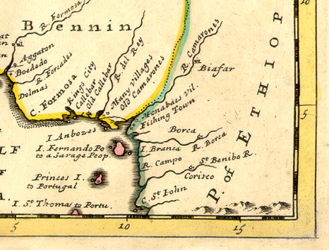
Description: Detail showing the Bight of Biafra from a map by Herman Moll, 1729, showing "NEGROLAND and GUINEA. With the European Settlements, Explaining what belongs to England, Holland, Denmark etc.
Title: 1729 West Africa map (Cameroon & Nigeria)
Credit: Atlas Minor, originally published in 1727." 20.1 X 27 cm. Published in London. The map shows the area from the Tropic of Cancer to Cameroon. From The University of Florida Map & Image Library.
Author: Herman Moll
Usage Terms: Public domain
License: Public domain
Attribution Required?: No
Image usage
The following page links to this image:

All content from Kiddle encyclopedia articles (including the article images and facts) can be freely used under Attribution-ShareAlike license, unless stated otherwise.
.jpg)