
Image: 1732 map of Maryland

Size of this preview: 369 × 599 pixels. Other resolutions: 148 × 240 pixels | 2,440 × 3,964 pixels.
Original image (2,440 × 3,964 pixels, file size: 478 KB, MIME type: image/jpeg)
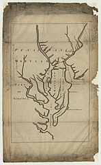
Description: Description Lord Baltimore’s map of Maryland, Pennsylvania, etc., annexed to his agreement with Messrs. Penn in the year 1732. Map made to accompany agreement between Lord Baltimore and Messrs. Penn
Title: 1732 map of Maryland
Credit: https://ghostsofbaltimore.org/2014/03/04/lord-baltimores-map-maryland-1732/
Author: Unknown authorUnknown author
Usage Terms: Public domain
License: Public domain
Attribution Required?: No
Image usage
The following 2 pages link to this image:

All content from Kiddle encyclopedia articles (including the article images and facts) can be freely used under Attribution-ShareAlike license, unless stated otherwise.