
Image: 1744 Wren Map of London, England - Geographicus - London-wren-1744
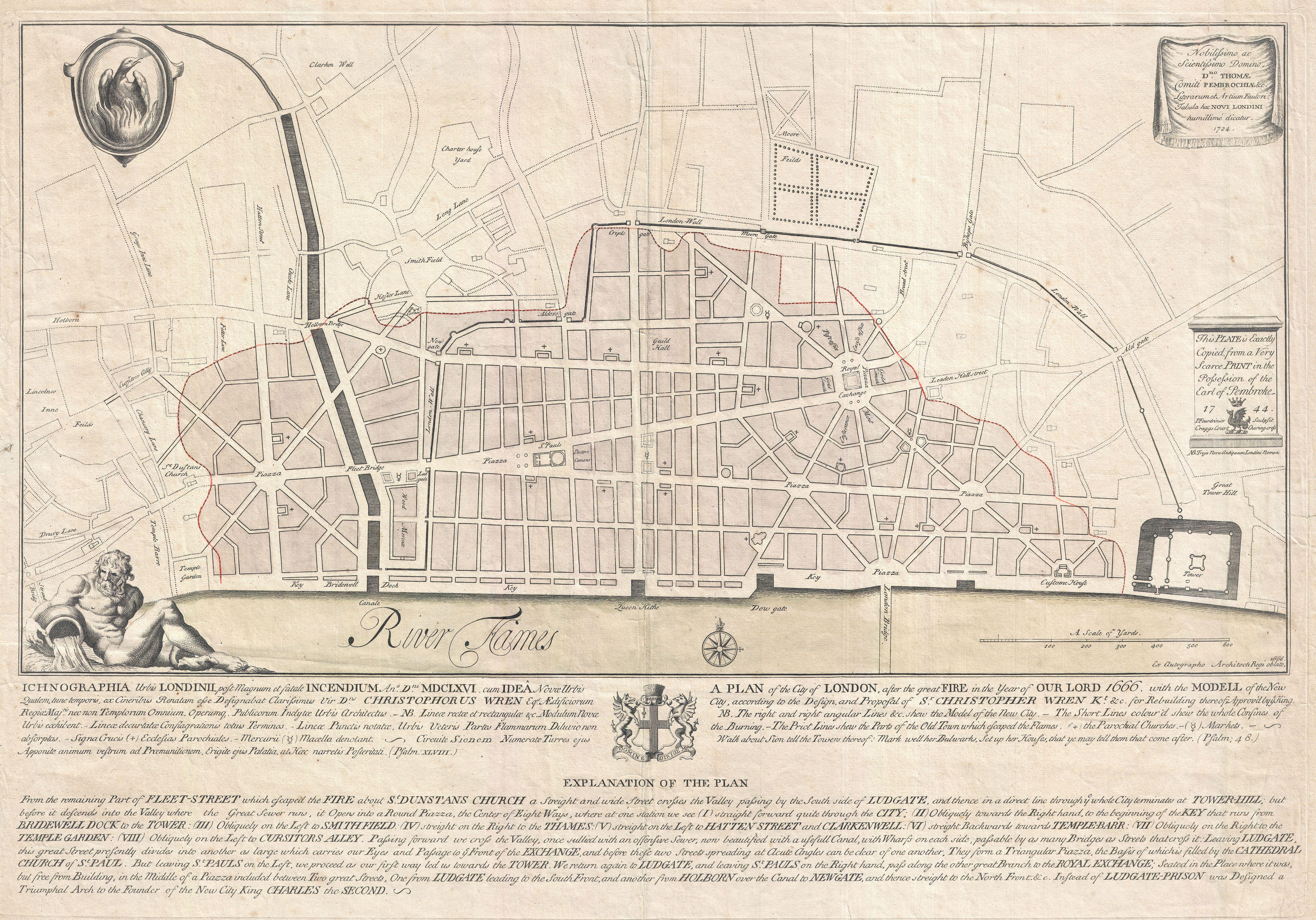
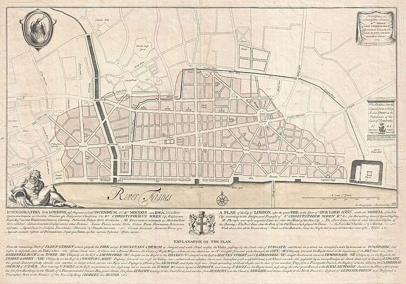
Description: An extremely scarce 1744 map of London showing Sir Christopher Wren's plan for reconstructing the city following the 1666 Great Fire of London. In 1666 the Great Fire swept through the old Roman portions of London, laying waste to most of the original walled city. Christopher Wren, a well known architect of the period was quick to respond to the disaster as a opportunity to dramatically redesign and modernize London's center. Wren having been schooled in Paris envisioned an elaborate classically influenced reconstruction of the city with broad avenues meeting in a series of Piazzas. Despite, or perhaps because of, Wren's promptitude in producing a plan for a major post-fire reconstruction, his plan exhibits a number of dramatic errors. Wren did not take the city's topography into account and consequently much of the this plan is unfeasible. Despite claims to the contrary in the document itself, Wren's plan was never seriously considered by either the King or the Parliament. Today Wren's original 1666 plan is lost. This version was drawn in 1744 by the once fashionable engrave P. Fourdrinier, who claims to have replicated exactly a scarce 1724 original owned by the Earl of Pembroke. This map covers London along the north side of the Thames River from Strand Bridge to Great Tower Hill. Shows Wren's detailed reconstruction plan, along with the regions originally destroyed by the Great Fire. Identifies the proposed locations of parochial churches, markets, piazzas, bridges and warehouses. A vignette in the lower left quadrant depicts Thamesis, the river god for which the Thames River is named. The upper left quadrant bears the image of a phoenix, suggesting that, like the mythical bird, London too would rise from its own ashes and be reborn in fire. The lower quadrants of this plate include the map's title in both English and Latin as well as a detailed Explanation of the Plan. This plan is highly uncommon and rarely appears outside of institutional collections.
Title: Ichnographia urbis Londinii… (A Plan of the City of London, after the great FIRE, in the Year of Our Lord 1666.)
Credit: This file was provided to Wikimedia Commons by Geographicus Rare Antique Maps, a specialist dealer in rare maps and other cartography of the 15th, 16th, 17th, 18th and 19th centuries, as part of a cooperation project. Deutsch | English | français | македонски | Nederlands | polski | +/−
Author: Christopher Wren
Permission: This is a faithful photographic reproduction of a two-dimensional, public domain work of art. The work of art itself is in the public domain for the following reason: This work is in the public domain in its country of origin and other countries and areas where the copyright term is the author's life plus 100 years or less. You must also include a United States public domain tag to indicate why this work is in the public domain in the United States. This file has been identified as being free of known restrictions under copyright law, including all related and neighboring rights. The official position taken by the Wikimedia Foundation is that "faithful reproductions of two-dimensional public domain works of art are public domain". This photographic reproduction is therefore also considered to be in the public domain in the United States. In other jurisdictions, re-use of this content may be restricted; see Reuse of PD-Art photographs for details.
Usage Terms: Public domain
License: Public domain
Attribution Required?: No
Image usage
The following page links to this image:
