
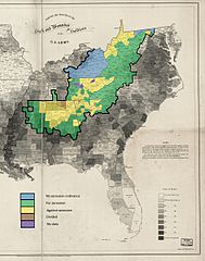
Image: 1860-61 Secession in Appalachia by County

Description: This is a map showing the voting in the various county votes of the southern states with boundaries within Appalachia on their states various ordinances of secession from the United States during the secession crisis of 1860-1861. The heavy black outline within the map shows the boundaries of the counties that are within the modern definition of Appalachia as described by the Appalachian Regional Commission. The basic map, showing slaves as a percentage of population, is public domain and was created in 1860 by the United States Coast Survey.
Title: 1860-61 Secession in Appalachia by County
Credit: Own work
Author: Dubyavee
Usage Terms: Creative Commons Attribution-Share Alike 4.0
License: CC BY-SA 4.0
License Link: https://creativecommons.org/licenses/by-sa/4.0
Attribution Required?: Yes
Image usage
The following page links to this image:
