
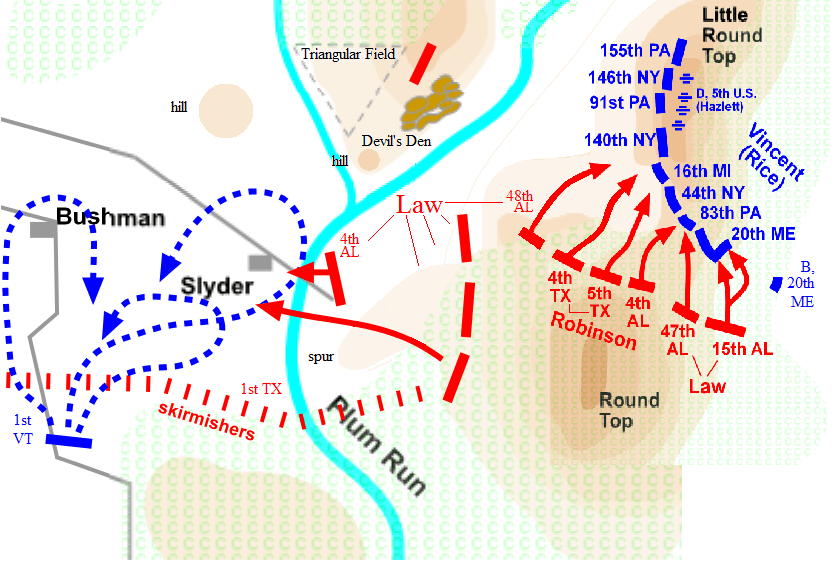
Image: 1863 Gettysburg Battlefield - Big Round Top, Days 2 and 3
Description: Confederate Big Round Top geography and adjacent features, with Confederate Battle of Gettysburg positions (red) on July 3 (left) & July 2 (right).
Title: 1863 Gettysburg Battlefield - Big Round Top, Days 2 and 3
Credit: Merge of File:Big Round Top.png, used for the more gradual W and NW Big Round Top slopes) with File:Little_Round_Top2.png reduced to the same scale (but missing the lower S slope). File:Little_Round_Top2.png also has notably different NW treeline and different color for the same contour level. The scale was matched using the centroid of each image's depicted summit region (dark brown) and using the depicted point of the stream confluence with Plum Run.1 Added features include the Big Round Top spur and the hills W & SW of Devil's Den. Labeled triangular field & marked 4th AL as a Law unit (the 46th AL on the left of the 15th AL need labeled on the spur,[1] as well as the July 3 Devil's Den unit). 1The depicted confluence on both source images is one of two streams that meet Plum Run at lat/long: 39.790006,-77.244133 - closer to Devil's Den (39.791393,-77.242776), or 39.789252,-77.245211 - closer to the Slyder road crossing (39.7883,-77.24571).
Author: Target for Today
Usage Terms: Creative Commons Attribution-Share Alike 2.5
License: CC BY-SA 2.5
License Link: https://creativecommons.org/licenses/by-sa/2.5
Attribution Required?: Yes
Image usage
The following page links to this image:
