
Image: 1873 Beers Map of Flushing and College Point, Queens, New York - Geographicus - Kissena Creek & Central RR 2A

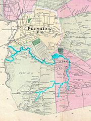
Description: A scarce example of Fredrick W. Beers’ map of Flushing and College Point, Queens, New York. published in 1873. Outlined in blue is the former Kissena Creek, which flowed east, north, then west towards Flushing Creek. Highlighted in black is the former Central Railroad of Long Island, which ran east from Flushing to Garden City, Long Island.
Title: Flushing, Queens Co. L.I.
Credit: This file was provided to Wikimedia Commons by Geographicus Rare Antique Maps, a specialist dealer in rare maps and other cartography of the 15th, 16th, 17th, 18th and 19th centuries, as part of a cooperation project.
Author: http://www.geographicus.com/mm5/cartographers/beers.txt
Usage Terms: Public domain
License: Public domain
Attribution Required?: No
Image usage
The following page links to this image:
