
Image: 1876 Port Kenyon Map

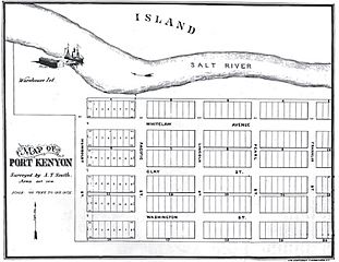
Description: A plat-map of the proposed town of Port Kenyon, California of which only a small portion was ever built. The Salt River flows from right (east) to left (west) in this image. The map was entered as a map to lay out streets with the Humboldt County Recorder of Deeds office on May 23, 1876.
Title: 1876 Port Kenyon Map
Credit: Humboldt County Recorder of Deeds Office
Author: A.T. Smith
Permission: This work is in the public domain in its country of origin and other countries and areas where the copyright term is the author's life plus 70 years or less. This work is in the public domain in the United States because it was published (or registered with the U.S. Copyright Office) before January 1, 1923. This file has been identified as being free of known restrictions under copyright law, including all related and neighboring rights.
Usage Terms: Public domain
License: Public domain
Attribution Required?: No
Image usage
The following page links to this image:
