
Image: 1882 map of Long Island Railroad

Size of this preview: 800 × 284 pixels. Other resolutions: 320 × 113 pixels | 6,294 × 2,232 pixels.
Original image (6,294 × 2,232 pixels, file size: 4.15 MB, MIME type: image/jpeg)
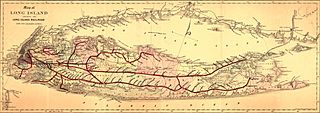
Description: Map of Long Island showing the Long Island Railroad and its leased lines. Also shows drainage, cities and towns, township and county boundaries, and the railroad network.
Title: 1882 map of Long Island Railroad
Credit: This map is available from the United States Library of Congress's Geography & Map Division under the digital ID g3802l.rr004470. This tag does not indicate the copyright status of the attached work. A normal copyright tag is still required. See Commons:Licensing for more information.
Author: G.W. & C.B. Colton & Co.
Usage Terms: Public domain
License: Public domain
Attribution Required?: No
Image usage
The following page links to this image:

All content from Kiddle encyclopedia articles (including the article images and facts) can be freely used under Attribution-ShareAlike license, unless stated otherwise.