
Image: 1930 California state highways

Size of this PNG preview of this SVG file: 514 × 600 pixels. Other resolution: 206 × 240 pixels.
Original image (SVG file, nominally 576 × 672 pixels, file size: 1.17 MB)
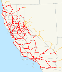
Description: This is a map of California's state highway system (constructed and proposed routes) as it existed in 1930. Email me if you would like a copy of the GIS data I created for the highways.
Title: 1930 California state highways
Credit: No machine-readable source provided. Own work assumed (based on copyright claims).
Author: No machine-readable author provided. NE2 assumed (based on copyright claims).
Usage Terms: Public domain
License: Public domain
Attribution Required?: No
Image usage
The following 2 pages link to this image:

All content from Kiddle encyclopedia articles (including the article images and facts) can be freely used under Attribution-ShareAlike license, unless stated otherwise.