
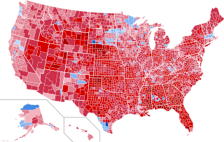
Image: 1972 United States presidential election results map by county

Size of this PNG preview of this SVG file: 555 × 352 pixels. Other resolution: 320 × 203 pixels.
Original image (SVG file, nominally 555 × 352 pixels, file size: 1.47 MB)
Description: County Results of the United States presidential election, 1972 McGovern—>90% McGovern—80-90% McGovern—70-80% McGovern—60-70% McGovern—50-60% McGovern—<50% Nixon—<50% Nixon—50-60% Nixon—60-70% Nixon—70-80% Nixon—80-90% Nixon—>90%
Title: 1972 United States presidential election results map by county
Credit: Own work
Author: Inqvisitor
Usage Terms: Creative Commons Attribution-Share Alike 3.0
License: CC BY-SA 3.0
License Link: https://creativecommons.org/licenses/by-sa/3.0
Attribution Required?: Yes
Image usage
The following page links to this image:

All content from Kiddle encyclopedia articles (including the article images and facts) can be freely used under Attribution-ShareAlike license, unless stated otherwise.