
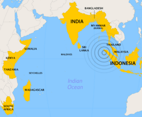
Image: 2004 Indian Ocean earthquake - affected countries

Size of this preview: 732 × 599 pixels. Other resolutions: 293 × 240 pixels | 800 × 655 pixels.
Original image (800 × 655 pixels, file size: 59 KB, MIME type: image/png)
Description: Map showing countries affected by the 2004 Indian Ocean earthquake
Title: 2004 Indian Ocean earthquake - affected countries
Credit: Created by Cantus using ArcView and Photoshop. Orthographic projection, centered at lat. 0°, long. 80°A
Author: Ævar Arnfjörð Bjarmason
Usage Terms: Creative Commons Attribution-Share Alike 3.0
License: CC-BY-SA-3.0
License Link: http://creativecommons.org/licenses/by-sa/3.0/
Attribution Required?: Yes
Image usage
The following page links to this image:

All content from Kiddle encyclopedia articles (including the article images and facts) can be freely used under Attribution-ShareAlike license, unless stated otherwise.