
Image: 2005 west nile map
No higher resolution available.
2005_west_nile_map.png (280 × 183 pixels, file size: 13 KB, MIME type: image/png)
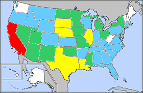
Description: Map of West Nile disease distribution in the U.S. for 2005. The color of each state indicates what percentage of total U.S. cases were reported in that state: white - no cases blue - less than 1% green - between 1% and 5% yellow - between 5% and 10% red - over 10%
Title: 2005 west nile map
Credit: Own work
Author: InNuce at English Wikipedia
Usage Terms: Public domain
License: Public domain
Attribution Required?: No
Image usage
The following page links to this image:

All content from Kiddle encyclopedia articles (including the article images and facts) can be freely used under Attribution-ShareAlike license, unless stated otherwise.