
Image: 2010ElectoralCartogramGott
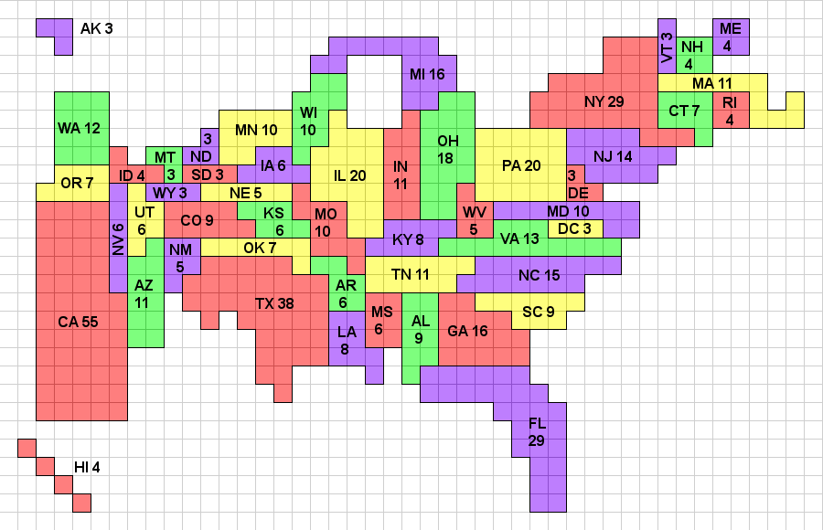
Description: Gott and Colley's Electoral Cartogram showing the electoral votes apportioned to each state as a result of the 2010 Census. Note that the cartogram is topologically correct in that any state that borders another state in reality borders that state on the cartogram, and wherever multiple states meet at a point in reality, they also do so on the cartogram. The color map uses a 4-color system, which because of the topological correctness, could be applied to a standard geographic map as well. A previous version of this cartogram (reflecting the 2000 apportionment) was published in Mathematical and Computer Modeling. This image, and a monochrome version will be maintained at http://www.colleyrankings.com/cartogram2010, where one may also expect to find polling and election information in 2012.
Title: 2010ElectoralCartogramGott
Credit: Own work
Author: Wes colley
Usage Terms: Creative Commons Attribution 3.0
License: CC BY 3.0
License Link: http://creativecommons.org/licenses/by/3.0
Attribution Required?: Yes
Image usage
The following page links to this image:
