
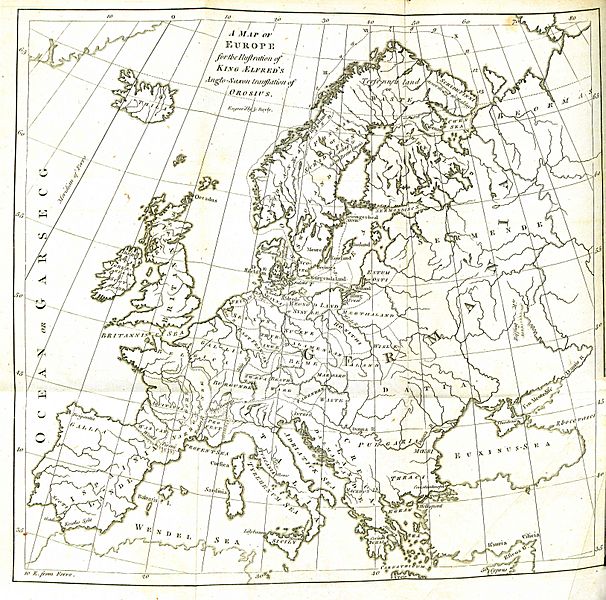
Image: A Map of Europe for the Illustration of King Alfred's Anglo-Saxon translation of Orosius. Engraved by J. Bayly

Description: Folding engraved map published in: Daines Barrington (ed./transl.), King Ælfred’s Orosius: The Anglo-Saxon Version, from the Historian Orosius. By Ælfred the Great. Together with an English Translation from the Anglo-Saxon. London: printed by W. Bowyer and J. Nichols: and sold by S. Baker and G. Leigh; T. Payne; and B. White, 1773, II, after p. 260. Drawn up by Johann Reinhold Forster and his son Georg Forster (uncredited, see: Johann Reinhold Forster, Geschichte der Entdeckungen und Schiffahrten im Norden. Frankfurt an der Oder: Carl Gottlieb Strauß, 1784, pp. XIII–XIV, and: Walter Goffart, Historical Atlases: The First Three Hundred Years, 1570–1870. Chicago/London: The University of Chicago Press, 2003, pp. 197, 200). Engraved by John Bayly. Republished, with some corrections, as “Karte von Europa zur Erläuterung der Erdbeschreibung des Mittel Alters, und von König Alfred’s Angel Säxischer Uebersetzung des Orosius. von Johann Reinhold Forster” in: Forster, op. cit. English version, “A Map of Europe for the Illustration of the Geography of the Middle Age and of King Alfred’s Anglo-Saxon translation of Orosius. by John Reinhold Forster”, engraved by Thomas Bowen, published in: John Reinhold Forster, History of the Voyages and Discoveries Made in the North. London: printed for G G. J. and J. Robinson, 1786, after p. 74. Description of the map (Barrington, op. cit., I, p. xxiv): "I have therefore annexed a map, which contains the names of most of the Europæan places mentioned in this geographical chapter, and have also traced the voyage of Ohthere and Wulfstan, in these Northern Seas. […] The pricked line describes Ohthere’s voyage, from Halgoland to the Cwen Sea, and back again; after which, he is supposed to sail for Sciringe’s-Heal, whence he went to Heathum. The plain line traces Wulfstan’s voyage, from Hæthum to Truso. The numbers in Roman capitals shew the places where these travellers stopped, after so many days sail. All the names of countries and towns, to the Northward of the Mediterranean, are in this map spelt precisely according to the Anglo-Saxon Orthography. I might, indeed, have inserted some additional places, mentioned in other parts of the Version; but as they are only taken notice of transiently, without any boundaries, there is, in most instances, only a very wide field for conjectures. As I advanced in the Translation also, I thought upon the whole it might render the English Version more intelligible, if I conformed to the more common orthography, both of places and persons."
Title: A Map of Europe for the Illustration of King Alfred's Anglo-Saxon translation of Orosius. Engraved by J. Bayly
Credit: Daines Barrington (ed./transl.), King Ælfred’s Orosius: The Anglo-Saxon Version, from the Historian Orosius. By Ælfred the Great
Author: Drawn up by Johann Reinhold Forster and his son Georg Forster
Usage Terms: Public domain
License: Public domain
Attribution Required?: No
Image usage
The following page links to this image:
