
Image: A Map of the Western parts of the Colony of Virginia, 1754

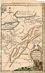
Description: Map of Western Virginia, centered on the Ohio and the Patomak Rivers, showing western settlements in Virignia. The map was among the first American maps to appear in the London Magazine. Map is based on the map of the Western part of Virginia from The Journal Of George Washington, Sent By The Hon. Robert Dinwiddie ... To The Commandant Of The French Forces On The Ohio . . . (London, 1754) . Map shows Washington's route from Williamsburg to the French fort on Lake Erie. A cartouche is adorned with natives producing tobacco. "Six Nations" annotation is found south of Katarakui or Ontario Lake. Lake Erie is named Lake Erri or Okswego. Niagara Falls are annotated "Niagara Cataract 137 feet."
Title: A Map of the Western parts of the Colony of Virginia, 1754
Credit: https://www.raremaps.com/gallery/detail/19253/a-map-of-the-western-parts-of-the-colony-of-virginia-london-magazine
Author: S. Gibson, sculptor
Usage Terms: Public domain
License: Public domain
Attribution Required?: No
Image usage
The following page links to this image:
