
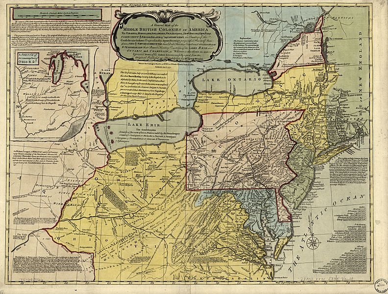
Image: A general map of the middle British colonies in America, viz. Virginia, Maryland, Delaware, Pensilvania, New-Jersey, New York, Connecticut & Rhode-Island- of Aquanishuonigy the country of the LOC 75693766

Description: Scale ca. 1:2,250,000. Hand colored. Relief shown pictorially. Shows "West longitude from London" and "from Philadelphia." Differs from other copies in absence of Connecticut River north of "Great Falls." Also differs in coloration of boundaries: Ohio and Kentucky River are colored as boundaries; Pennsylvania extends north to a line at approximately 42⁰40ʹ; Maryland extends west to "Yochio Geni," Canada is colored as having a boundary west of Lake Ontario, etc. Includes text, historical notes, distance charts, and inset of "A sketch of the remaining part of Ohio R. &c." LC Maps of North America, 1750-1789, 716 Available also through the Library of Congress Web site as a raster image. Vault AACR2
Title: A general map of the middle British colonies in America, viz. Virginia, Maryland, Delaware, Pensilvania, New-Jersey, New York, Connecticut & Rhode-Island- of Aquanishuonigy the country of the LOC 75693766
Credit: https://www.loc.gov/item/75693766/
Author: Evans, Lewis; Bowles, Carington
Permission: This map is available from the United States Library of Congress's Geography & Map Division under the digital ID g3710.ar071604. This tag does not indicate the copyright status of the attached work. A normal copyright tag is still required. See Commons:Licensing for more information.
Usage Terms: Public domain
License: Public domain
Attribution Required?: No
Image usage
The following 2 pages link to this image:
