
Image: Administrative divisions of Azerbaijan Democratic Republic 2

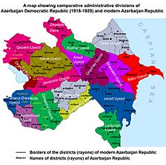
Description: A map showing comparative administrative divisions of Azerbaijan Democratic Republic (1918-1920) and modern Azerbaijan Republic. Based on the sources listed below: 1. Official Map of the Azerbaijan Democratic Republic 1920 Tsarist Russia and Islam in the Caucasus By Firouzeh Mostashari. Page XI. Maps. 2.Official Map Issued by the Azerbaijan Democratic Republic 1919 The Azerbaijani Turks: power and identity under Russian rule By Audrey L. Altstadt 3.Azerbaijan Democratic Republic By Professor Musa Qasimly The map of ADR (Azerbaijan Democratic Republic) issued in Russian in 1920 by Ministry of Foreign Affairs of ADR. p.88 4.The Democratic Republic of Azerbaijan (1918 – 1920). Area: 114,000 sq. km 5.Map of the Republic of Azerbaijan
Title: Administrative divisions of Azerbaijan Democratic Republic 2
Credit: Own work
Author: Melikov Memmed
Usage Terms: Creative Commons Zero, Public Domain Dedication
License: CC0
License Link: http://creativecommons.org/publicdomain/zero/1.0/deed.en
Attribution Required?: No
Image usage
The following image is a duplicate of this image (more details):
The following page links to this image:
