
Image: Africa North 1578, Gerardus Mercator (4154597-recto)

Size of this preview: 800 × 558 pixels. Other resolutions: 320 × 223 pixels | 5,508 × 3,840 pixels.
Original image (5,508 × 3,840 pixels, file size: 2.68 MB, MIME type: image/jpeg)
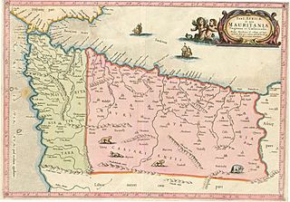
Description: Ptolemy's First Map of Africa, with Mauretania Tingitana and Caesariensis, covering modern Morocco and western Algeria.
Title: Africa North 1578, Gerardus Mercator (4154597-recto)
Credit: North West University Library, 16th-20th Century Maps of Africa, #4154597
Author: Gerardus Mercator
Usage Terms: Public domain
License: Public domain
Attribution Required?: No
Image usage
The following page links to this image:

All content from Kiddle encyclopedia articles (including the article images and facts) can be freely used under Attribution-ShareAlike license, unless stated otherwise.
.jpg)