
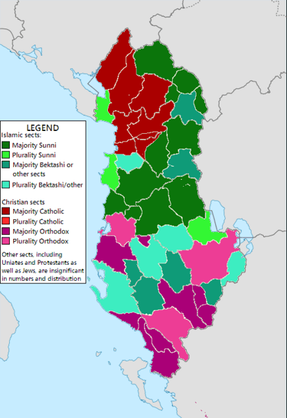
Image: Albania confessional map with regions circa 1900

Description: Based on various census data (as well as various other scholarly publications and a map), with some approximation involved, as the borders of regions have changed since the times of these censuses. Sources and notes: 1. Gruber, Siegried. Regional variation in marriage patterns in Albania at the beginning of the 20th century. Data ultimately derived from the 1918 census. See here (maps found near bottom): www-gewi.uni-graz.at/seiner/marriage_patterns.html. See also this map: [1]. Used for info on Northern and Central Albania. Unfortunately, due to the political instability there, the South was not included in this census, nor were certain eastern regions (Bulqiza, Librazhd, etc.). 2. Vickers, Miranda. Islam in Albania. --Used for Bulqiza (she notes Bulqiza has an overwhelming Bektashi Muslim majority). While this is a 2008 source, I'm counting it for c1900 too, as it's unlikely that Bulqiza would've converted en masse to Bektashism since then. (http://www.google.com/url?sa=t&rct=j&q=&esrc=s&source=web&cd=2&ved=0CDYQFjAB&url=http%3A%2F%2Fwww.da.mod.uk%2Fcolleges%2Farag%2Fdocument-listings%2Fbalkan%2F08%2809%29MV.pdf&ei=HwuBU_LXGOfNsASLuYHIAg&usg=AFQjCNHfuCyKF6OSx1CFDQg7x8lloHi74w&sig2=p1qCw3JxZOttqZFz6evyGw&bvm=bv.67720277,d.cWc). 3. Destani, Beytullah. Albania and Kosovo: Political and Ethnic Boundaries, 1867-1946. --Used for Ottomon census data of the late 1800s and 1908 (also contains the distorted Greek nationalist and later Albanian nationalist-produced figures of South Albania). Note also that Pogradec is called 'Starovo'. Used for Southern Albania 4. This late 19th-century Greco-German ethno-religious map of Northwest Greece and Southern Albania, all the way up to Myzeqe 5. De Rapper, Gilles. Religion in Post-Communist Albania. (link: http://hal.archives-ouvertes.fr/docs/00/32/72/00/PDF/de_Rapper_2008_Religion_in_postcommunist_Albania.pdf) --Info on Devoll, a newly created district, as majority Muslim. Other notes: 1. I wasn't able to find any sources on Librazhdi at this time, so I just assumed majority Sunni like most of the surrounding region. If there is sources otherwise, do not hesitate to fix this. 2. While Shkodra district was in fact (slightly) majority Muslim in 1918, since then overwhelmingly Catholic regions of Kiri and the western part of Puka were added to Shkodra District, causing Catholics to become the majority. 3. Kuchova, a new district, is estimated based on its rough location on the Greco-German map. 4. The large number of districts with pluralities in the South is due to three different groups (Bektashis, Orthodox Christians and Sunnis) each having substantial numbers. 5. The modern day Mat District is a combination of the former Matja (overwhelmingly Sunni) and the former Oheri (overwhelmingly Catholic). According to the 1918 census there is also a small but significant (1-10%) Orthodox minority in the former Matja district (on top of a similarly sized Catholic minority in the district). 6. For the purposes of this map, very weak majorities (such as 50-53%) are being considered pluralities, given that there is some estimation involved.
Title: Albania confessional map with regions circa 1900
Credit: Own work
Author: Yalens
Usage Terms: Creative Commons Attribution-Share Alike 3.0
License: CC BY-SA 3.0
License Link: http://creativecommons.org/licenses/by-sa/3.0
Attribution Required?: Yes
Image usage
The following page links to this image:
