
Image: Albany ny physical map

Size of this preview: 622 × 599 pixels. Other resolutions: 249 × 240 pixels | 1,038 × 1,000 pixels.
Original image (1,038 × 1,000 pixels, file size: 1,015 KB, MIME type: image/png)
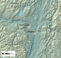
Description: Map showing the physical geography in the area around Albany, New York.
Title: Albany ny physical map
Credit: Own work, Elevation data from SRTM, water features and urban areas from Vector Map, county and state lines from U.S. Census Bureau.
Author: Kmusser
Usage Terms: Creative Commons Attribution-Share Alike 3.0
License: CC BY-SA 3.0
License Link: http://creativecommons.org/licenses/by-sa/3.0
Attribution Required?: Yes
Image usage
The following page links to this image:

All content from Kiddle encyclopedia articles (including the article images and facts) can be freely used under Attribution-ShareAlike license, unless stated otherwise.