
Image: Ambae island 3D pic

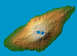
Description: en : Ambae Island, Vanuatu. False-color, computed shadows. Colored according to elevation. Elevation data acquired by the Shuttle Radar Topography Mission on 2000-02-11 aboard Endeavour shuttle. fr: L'ile de Ambae dans l'archipel de Vanuatu. Image en relief obtenue d'apres des relevés pris par la navette Endeavour en février 2000 Location: 15.4 degree south latitude, 167.9 degrees east longitude Orientation: North toward the top, Mercator projection Size: 36.8 by 27.8 kilometers (22.9 by 17.3 miles) Image Data: shaded and colored SRTM elevation model Date Acquired: February 2000 original name : PIA06675.jpg
Title: Ambae island 3D pic
Credit: http://photojournal.jpl.nasa.gov/catalog/PIA06675
Author: NASA/JPL/NGA
Usage Terms: Public domain
License: Public domain
Attribution Required?: No
Image usage
The following page links to this image:
