
Image: Aquitani tribes map-fr

Size of this PNG preview of this SVG file: 702 × 600 pixels. Other resolution: 281 × 240 pixels.
Original image (SVG file, nominally 878 × 750 pixels, file size: 1.26 MB)
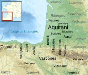
Description: Map of the Aquitani and surrounding tribes in early Roman times. Black: pre-Indoeuropean tribes. Grey: Celtic tribes.Note: the macro-ethnicity of some of the tribes is disputed.
Title: Aquitani tribes map-fr
Credit: France_map_Lambert-93_topographic-blank.svg by Eric Gaba (Sting - fr:Sting) under licence GFDL or CC-BY-SA Aquitani.gif by Sugaar, uploaded by Michel BUZE under licence Public Domain Blank_map_of_Gaul_1st_century_BC.svg (location map) by historicair under licence GFDL or CC-BY-SA
Author: Sémhur
Usage Terms: Creative Commons Attribution-Share Alike 4.0
License: CC BY-SA 4.0
License Link: https://creativecommons.org/licenses/by-sa/4.0
Attribution Required?: Yes
Image usage

All content from Kiddle encyclopedia articles (including the article images and facts) can be freely used under Attribution-ShareAlike license, unless stated otherwise.